
- 19 Countries in the Americas Trained in Geospatial AI for Faster Emergency Analysis
- Russia Restricts Nighttime Mobile Networks to Disrupt Drone Operations Guided by Geolocation Signals
- Geopost Transforms Delivery Fleet into a High-Frequency Mapping Asset
- Construction Emerges as a Global Leader in Geospatial Innovation
- Saudi Arabia Explores Data Embassies as Part of Its Sovereign AI Strategy
- A Maine Map Library Brings Centuries of Cartography to Life for Students and Researchers
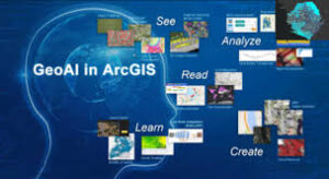
19 Countries in the Americas Trained in Geospatial AI for Faster Emergency Analysis
PAHO and WHO held a regional virtual session in partnership with Esri to strengthen the ability of health and emergency teams to use geospatial artificial intelligence for rapid decision-making. The training introduced recent advances in GeoAI, deep learning, and AI assistants across ArcGIS tools, showing how automated feature extraction, land cover classification, road detection, and change detection can speed up emergency mapping. Participants from 19 countries learned how these tools support early warning systems and help modernize disaster risk management across the Americas.
Read more here.
Russia Restricts Nighttime Mobile Networks to Disrupt Drone Operations Guided by Geolocation Signals
Russia has begun shutting down mobile data services at night in border regions to limit long range drone strikes that rely on cellular networks for navigation. Both Russian and Ukrainian drones use LTE modems and SIM cards to maintain geolocation linked control beyond normal radio range, allowing operators to redirect aircraft in real time and guide them toward specific targets. By cutting or filtering phone signals, authorities aim to prevent drones from using the network as a spatial communication layer. Analysts note that the measure reflects a growing challenge in modern conflicts, where location based technologies and commercial telecom systems have become part of the battlespace.
Read more here.

Geopost Transforms Delivery Fleet into a High-Frequency Mapping Asset
Geopost an international parcel delivery service based in France, has launched a new journey called Geopost Vision, that turns its vast delivery fleet into a continuous, GDPR-compliant data collection system for mapping and infrastructure companies. With over 65,000 vehicles covering two billion kilometers across Europe, connected dashcams capture high-frequency street-level imagery to detect changes in the streetscape, such as new road signs and traffic lights. The data is anonymized and shared with clients via APIs to support mapping, autonomous mobility, and urban infrastructure projects. This initiative aims to offer a unique resource for infrastructure planners and mobility companies.
Read more here.

Construction Emerges as a Global Leader in Geospatial Innovation
Topcon Positioning Systems, as a global leader in developing and manufacturing precision positioning workflow, highlights how the construction sector has become one of the strongest adopters of geospatial technology worldwide. With widespread use of GNSS, RTK correction services, and advanced reality capture tools, construction has built a mature digital workflow that delivers centimeter-level accuracy even in GNSS-challenged environments.

The sector’s experience shows policymakers how high-precision positioning, BIM integration, and smartphone-based 3D mapping can support national initiatives such as the UK’s Geospatial Strategy and the National Underground Asset Register. As geospatial tools move into mass-market applications, construction serves as a model for how precision data and digital twins can scale across industries.
Read more here.
Saudi Arabia Explores Data Embassies as Part of Its Sovereign AI Strategy
Saudi Arabia is positioning itself as a host for “data embassies,” facilities that store another country’s sensitive digital information while operating under the laws of the data owner. The model, first used by Estonia and Monaco, is now being reconsidered as nations seek secure, resource-rich locations to build AI infrastructure.
Saudi Arabia’s proposed framework outlines three levels of autonomy for foreign data, but experts note that real implementation will require complex bilateral agreements and deep trust between countries. With its strategic location and low land and power costs, Saudi Arabia hopes to attract governments and tech firms, though concerns remain about sustainability, regulatory clarity and long-term political risk.
Read more here.

A Maine Map Library Brings Centuries of Cartography to Life for Students and Researchers
The Osher Map Library at the University of Southern Maine is giving students hands-on access to one of the largest public map collections in the United States, with materials spanning from 1475 to modern celestial charts. The library encourages visitors to handle historic globes, atlases and thematic maps, helping them understand how mapmakers shaped perceptions of place, power and culture long before digital tools existed.

Faculty use the collection to teach global history, spatial storytelling and cartographic perspectives, showing how traditional mapping conventions influence modern platforms such as satellite maps and Street View. Recent acquisitions, including an 1830 Jain cosmology map found in a Maine attic, highlight how material maps continue to reveal cultural meaning and the evolution of spatial thinking.
Read more here.


Be the first to comment