
As 2024 comes to a close, let’s take a moment to reflect on some of the most significant stories that shaped the geospatial world this year. From groundbreaking AI model launches to major organizational mergers and innovative web maps leveraging GIS, it’s been a year of remarkable developments. And let’s not forget the record-breaking heat as 2024 once again broke all records.
In this year-end wrap-up, we’ve curated the standout stories in block format. These stories were thoughtfully discussed and selected by the GoGeomatics volunteer team before making their way into this digest.
Addressing climate change using GeoAI
GeoAI is increasingly playing a pivotal role in addressing climate change by harnessing the power of spatial data and artificial intelligence. From predicting environmental impacts to optimizing resource management, GeoAI provides invaluable insights that support sustainable solutions and help mitigate the effects of climate change. Below is a list of key stories in this sphere that defined 2024.
Mapping overfishing and untracked vessels on the oceans
Using satellite photos and artificial intelligence, a new study indicates that over 75% of industrial fishing is not publicly documented.
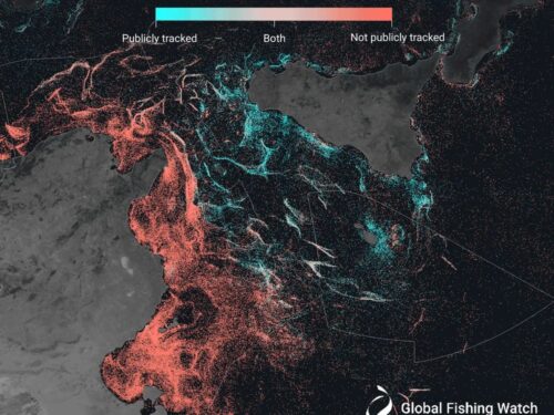
To reach this result, the researchers gathered data from automatic identification systems (AIS), which transmit a ship’s location and speed, thereby making its journey a public record. They then evaluated two million gigabyte of satellite data from the European Space Agency to construct a picture of maritime traffic between 2017 and 2021. Read full article here. Explore the map here.
Rapidly thawing permafrost is risky for people and the environment
Permafrost, or perpetually frozen ground, is rapidly disappearing throughout the Arctic.
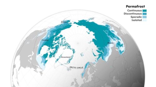
To make matters worse, thawing permafrost may hasten global warming. However, it is unclear how quickly this collapse will proceed, and what this means for people and the world.
Researchers use geographic information system (GIS) technology to record changes, simulate their effects on people and the environment, and forecast future scenarios. As it maps the defrost, the project intends to empower local communities while also guiding much-needed federal and global policies. Read full article here.
High-resolution imagery helps map global tree canopy using AI
Meta, a giant tech company, and the World Resources Institute, a nonprofit organization, combined high-resolution satellite imagery and cutting-edge artificial intelligence technology to collect data and create an open-source model that can predict canopy height from both satellite and aerial data.
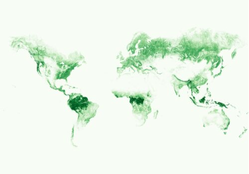
The canopy height map can be used to set baselines for conservation and restoration efforts and to begin extracting above ground biomass. According to research, 35 million km2 have a canopy height greater than 5 meters, and more than one-third of the planet’s area (50 million km2) has a canopy height above 1 meter. The dataset examines the finest satellite imagery available between 2009 and 2020. Read full article here.
2024 was the hottest year on record
Sea level rise, ocean warming, and glacier ice loss are all speeding up, making 2015–2024 the warmest decade on record. Extreme weather is also having a devastating impact on industries and people worldwide.
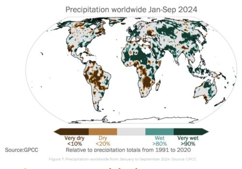
According to a WMO analysis of six international datasets, the global mean surface air temperature from January to September 2024 was 1.54 °C (with a margin of error of ±0.13 °C) higher than the pre-industrial normal, helped by a warming El Niño episode. Read full article here.
Significant mergers and acqusitions
2024 was a year marked by a few significant mergers and acquisitions that reshaped the geospatial landscape. These strategic moves reflect the industry’s ongoing consolidation and the drive for innovation, with companies seeking to expand their capabilities and strengthen their positions in a rapidly evolving market. From tech giants joining forces to specialized firms merging for greater impact, these acquisitions signal a new era of collaboration and competition in the geospatial sector.
Acquisition of Cesium by Bentley: A Revolution in the 3D Infrastructure Sector
Bentley Systems’ acquisition of Cesium, a premier platform for real-time 3D geospatial data, is a key step toward the merger of infrastructure software and geospatial technology. By combining Cesium’s powerful 3D visualization capabilities with Bentley’s digital twin and infrastructure management technologies, the acquisition seeks to revolutionize how we design, manage, and interact with infrastructure.

This merger has the potential to reshape how we design, manage, and maintain infrastructure on a global scale. Read full article here
EarthDaily Analytics Announces Acquisition of Descartes Labs
EarthDaily Analytics, a vertically integrated provider of Earth Observation (“EO”) data, analytics, and solutions, has acquired Descartes Labs, a pioneer in providing actionable insight to global organizations, as well as its entirely owned subsidiary, Descartes Labs Government, Inc.
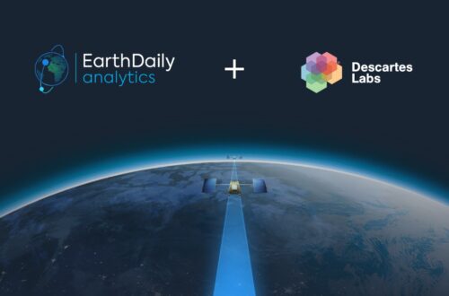
The entire scope of this collaborative effort will become prominent with the debut of the EarthDaily Constellation in 2025, which will change the game in EO by imaging the world’s landmasses and relevant maritime areas on a daily basis, resulting in a scientific-quality data source designed specifically for AI applications. Read full article here
Privateer acquires Orbital Insight

On May 6, the geospatial data analysis company Orbital Insight was bought by the space situational awareness company Privateer. Privateer’s Wayfinder data engine integrated with Orbital Insight’s TerraScope analytics platform, has brought together data and information from all fields, from space to the ocean. Read full article here.
NV5-Axim Merger: GIS Growth or Just Capture Market Share?
Through a number of well-timed acquisitions, most notably Axim Geospatial, NV5 Global, Inc. has established itself at the forefront of the geospatial industry’s evolution. This merger is a component of NV5’s larger aim to become a comprehensive, end-to-end provider of geospatial solutions rather than a group of specialized service providers.
NV5’s strategy may prove to be the paradigm for success as the industry moves toward more scalable and integrated solutions. To mitigate the industry’s slow development, which was mostly due to service segmentation among multiple vendors, NV5’s combined service offering correlates with the growing trend toward amalgamation and integrated services.
Clients may now work with a single source for all their geospatial needs, including location intelligence, cloud services, advanced analytics, and infrastructure security. Read full article here
Others
The year also brought a range of interesting developments in the geospatial world. While not necessarily groundbreaking, these stories highlight the ongoing innovation and diverse trends shaping the industry.
NOAA intends to change three key vertical datums
NOAA is right now focusing on three major vertical datum updates: the 1983–2001 NTDE, the International Great Lakes Datum of 1985 (IGLD 85), and the North American Vertical Datum of 1988.
NOAA now uses the 1983-2001 National Tidal Datum Epoch (NTDE), a 19-year period established by the National Ocean Service for gathering observations on water levels and producing tidal datum values . This epoch is currently being revised and will be replaced by the fifth iteration of the NTDE.

The International Great Lakes Datum (IGLD) is a standard reference system for measuring water level heights in the Great Lakes, their associated rivers, and the St. Lawrence River System. Unlike the NTDE, each location only has one water level measurement – mean water level. To account for crustal shifts and precisely monitor water levels, the IGLD must be revised every 25-30 years.
This datum measures the height of land, whereas the 2001 National Tidal Datum Epoch (NTDE) and International Great Lakes Datum (IGLD) measure the height of water. The revised datum will replace the existing datum (NAD88), which was created using traditional leveling and surveying techniques. Read full article here
First wooden satellite developed in Japan made it to space
Japanese researchers constructed the first wooden spacecraft in history, which was sent into orbit. As humans investigate space living, the palm-sized LignoSat—named after the Latin word for “wood”—is provided with showcasing the renewable material’s cosmic possibilities.

Because there is no oxygen or water to decay or inflame wood, it is more resilient in space than on Earth, Murata continued. According to the experts, a wooden satellite also lessens its final environmental impact. Read full article here.


Be the first to comment