")
- Satellite Data and AI Support Water Monitoring and Climate Resilience
- AI and GPU Acceleration Move Geospatial Processing Closer to Real-Time and Into Orbit
- China Expands Large-Scale Ocean Mapping With Strategic and Military Implications
- Strait of Hormuz Crisis Accelerates Demand for Real-Time Geospatial Intelligence
- Pokémon Go’s Crowdsourced Imagery Is Now Helping Train Delivery Robots
- Geospatial Data Gains Ground in Environmental and Sustainability Compliance Reporting
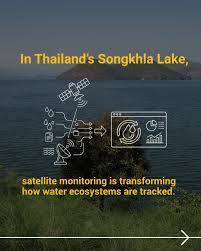
Satellite Data and AI Support Water Monitoring and Climate Resilience
New projects in Asia are showing how satellite data and AI can help close water data gaps and improve decision-making. In Indonesia, an AI-based tool is helping identify suitable locations for retention ponds, while in Thailand, satellite remote sensing is being used to improve water quality monitoring in Songkhla Lake.
At the same time, Sentinel-1 radar data show that many of the world’s major river deltas are sinking faster than expected. In places such as the Mekong, Chao Phraya, and Yellow River deltas, land subsidence is now worsening flood and sea-level risks, highlighting the growing value of satellite monitoring for environmental planning.
Read the full stories here and here.
AI and GPU Acceleration Move Geospatial Processing Closer to Real-Time and Into Orbit
Planet Labs and NVIDIA are advancing AI-driven geospatial processing by shifting from traditional CPU-based workflows to GPU-native systems. This approach enables satellite imagery to be processed in seconds rather than hours, supporting faster insights for applications such as disaster response, environmental monitoring, and global-scale analysis.
At the same time, NVIDIA is expanding AI capabilities beyond Earth by introducing space-ready computing platforms that enable real-time data processing directly onboard satellites and in orbit. These developments mark a shift toward edge computing in space, where data can be processed at the source, reducing latency and enabling more autonomous and responsive geospatial intelligence systems.
Read the full stories here and here.

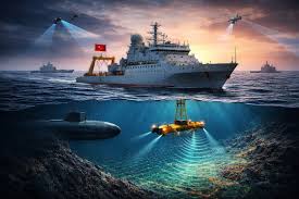
China Expands Large-Scale Ocean Mapping With Strategic and Military Implications
China is significantly expanding its ocean mapping efforts across the Pacific, Indian, and Arctic oceans, using research vessels and subsea sensors to collect detailed data on seabed terrain and water conditions. While some of this work supports scientific research, fisheries, and resource exploration, experts note that the data also has clear strategic value for submarine navigation and undersea operations.
The scale and consistency of these mapping activities are raising concerns among defense analysts, as such data can improve submarine deployment, detection, and overall maritime awareness. With increasing focus on key regions such as the South China Sea, Malacca Strait, and areas near U.S. and allied military bases, these efforts highlight the growing role of geospatial data in modern naval strategy.
Read more here.
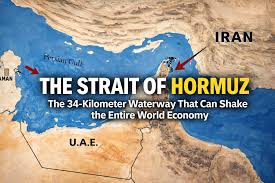
Strait of Hormuz Crisis Accelerates Demand for Real-Time Geospatial Intelligence
Rising tensions in the Strait of Hormuz are driving increased demand for commercial geospatial intelligence, as governments and industries seek real-time visibility into rapidly changing maritime conditions. The crisis has highlighted the need for tools that go beyond satellite imagery, combining multiple data sources to track vessel movements and monitor disruptions in one of the world’s most critical shipping corridors.
Companies are responding by integrating satellite imagery with AIS ship tracking data, drone feeds, and open-source intelligence into AI-powered platforms that deliver continuous situational awareness. These systems allow users to query complex datasets and generate near real-time insights, marking a shift toward more dynamic and responsive geospatial intelligence in high-risk environments.
Read more here.
Pokémon Go’s Crowdsourced Imagery Is Now Helping Train Delivery Robots
Photos and videos collected over the years by Pokémon Go players have helped build a massive street-level visual dataset that is now being used to train robotics systems. Niantic Spatial has transformed this crowdsourced imagery into a large geospatial model designed to support localization, 3D reconstruction, and environmental understanding for machines operating in real-world settings.
The technology is already being applied to delivery robotics, where precise positioning is critical, especially in dense urban areas where GPS often struggles. By comparing live camera feeds against its visual database, Niantic’s visual positioning system helps robots navigate more accurately, showing how consumer-generated geospatial data is finding new value in autonomous systems.
Read more here.

Geospatial Data Gains Ground in Environmental and Sustainability Compliance Reporting
A new study highlights the growing role of geospatial data in environmental compliance reporting, as sustainability regulations, particularly in the European Union, become more stringent and data-driven. Frameworks such as the Corporate Sustainability Reporting Directive (CSRD) and EU Deforestation Regulation (EUDR) are increasing demand for verifiable, transparent reporting, creating a stronger need for Earth observation and GIS-based workflows.
The study proposes structured geospatial workflows for risk screening, impact attribution, and independent verification, positioning satellite and GIS data as essential tools for regulatory compliance rather than supplementary inputs. As sustainability reporting shifts toward standardized and auditable systems, geospatial data is emerging as a key bridge between environmental policy, corporate reporting, and real-world accountability.
Read more here.


Be the first to comment