
- Visualizing the Gaza conflict through maps and satellite imagery
- Charting global ecosystems to drive meaningful action
- Combining lidar and sonar to transform seafloor mapping
- Meet Owl: Planet’s most sophisticated satellite mission to date
- Topcon asserts its position in the geomatics industry
- ESA launches Earth Observation tender to advance climate change adaptation efforts
Visualizing the Gaza conflict through maps and satellite imagery
To better understand the scale and impact of the conflict in Gaza, a story map has been developed using a combination of destruction maps, displacement data, and satellite imagery from Copernicus Sentinel-1. This map provides a powerful before-and-after comparison of key areas across Gaza, showing the extent of damage to neighborhoods, critical infrastructure, and agricultural land.
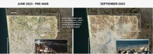
Two years of war have left Gaza in ruins. According to the Hamas-run health ministry, over 67,000 Palestinians have been killed, while nearly the entire population has been displaced. The population has been forced to relocate multiple times as Israeli operations shifted, initially ordering civilians from the north to move south, then later designating new evacuation zones in the south.
Read full article here: Gaza war in maps
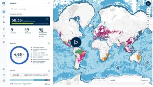
Charting global ecosystems to drive meaningful action
Combining lidar and sonar to transform seafloor mapping
Florida’s Seafloor Mapping Initiative (FSMI), a large‑scale project by Woolpert and partners under the Florida Department of Environmental Protection is using a combination of topobathy lidar and multibeam sonar to map tens of thousands of square kilometres of Florida’s coastal waters, including challenging areas like the Florida Keys and remote offshore zones.
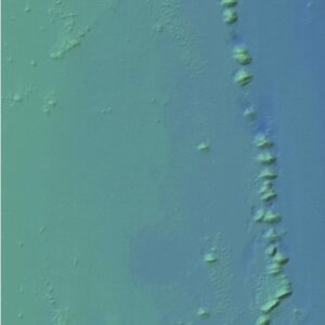
Key goals include improving navigation safety, habitat protection, coastal resilience, and ecological management. The high‑resolution data help locate underwater features like submerged channels, reefs, manatee habitat, blue holes, wrecks, and mangroves. The project also pushes technological boundaries, using uncrewed surface vessels for sonar surveys, Starlink communications for remote operations, automated data processing, and 24‑hour data collection workflows. These innovations serve to speed up mapping, ensure data quality, and make the finished datasets publicly accessible.
Read full article here: LiDAR + Sonar
Meet Owl: Planet’s most sophisticated satellite mission to date
Owl is a next-generation Earth observation satellite fleet, designed to deliver 1-meter class, near-daily imagery at low latency, with insights available within one hour of capture. Building on its mission since 2011 to make Earth visible and actionable, Planet has developed the world’s largest commercial network of Earth-imaging satellites. Owl will enhance this capability with AI at the edge, using onboard NVIDIA GPUs to process and analyze data directly in space.
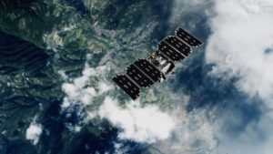
It will complement the existing SuperDove fleet, maintaining compatibility while boosting resolution and speed. The Owl constellation is built on Planet’s upgraded modular SmallSat platform and is designed to support a wide range of use cases, from disaster response and environmental monitoring to global security and vessel detection. Owl represents a leap in Earth observation by combining high-resolution imagery, low latency, and AI-powered analysis, reinforcing Planet’s leadership in the commercial satellite data sector.
Read full article here: Spacecraft Owl
Topcon asserts its position in the geomatics industry
Topcon Positioning Systems has revealed a strategic change by launching a specialized global business unit centered on geomatics, signaling a return to its original focus on surveying and mapping after several years of emphasizing construction and agriculture. This initiative features an expanded range of hardware and software designed to simplify workflows, enhance data accuracy, and improve visualization in surveying, GIS, and reality capture fields. The restructuring demonstrates Topcon’s goal to consolidate and advance its geospatial technologies, which were formerly part of its construction division.

This renewed focus signals Topcon’s commitment to supporting both traditional and emerging sectors reliant on spatial intelligence.
Read full article here: TopCon in Geomatics
ESA launches Earth Observation tender to advance climate change adaptation efforts
The European Space Agency (ESA) has issued a new Invitation to Tender aimed at utilizing Earth Observation (EO) to aid climate change adaptation. ESA is inviting experts in EO and adaptation to examine the Statement of Work and consider submitting proposals. The purpose of this initiative is to investigate how EO can be used to create innovative adaptation and/or risk indicators that track the effectiveness of adaptation measures over long-term climate periods (decades). Chosen feasibility case studies will showcase the practical application of these EO-based indicators in various regions and settings.
Read full article here: ESA Invitation


Be the first to comment