• facebook
  • Twitter
  • Linkedin
  • Youtube
  • Linkedin Group
  • Post a Job
  • Post an Ad
  • Post an Event
  • Post a Directory Listing
  • Post a Press Release
  • Media Kit
  • My Account
  • Login
GoGeomatics
  • MAGAZINE
    • BIM & GIS
    • Community
    • Conference news
    • Earth Observation
    • Education & Careers
    • GEOAI
    • Announcements
    • Reality Capture & Lidar
    • Science
    • Technology
    • Between the Poles
  • Directories
    • ASSOCIATION
    • INDUSTRY
    • EDUCATION
    • Open Data
  • EVENTS
    • GeoIgnite Events
    • Events Calendar
    • GoGeomatics Meetups
  • Services
    • Advertising
    • Marketing
    • Post a Job
    • Post an Ad
    • Post an Event
    • Post a Press Release
    • Post a Directory Listing
    • Media Kit
    • Web Design
  • Find a Job
  • Volunteer
    • Start a GoGeomatics Group
    • Editors & Writers Group
  • About Us
    • About Us
    • Contact Us
    • Frequently Asked Questions
  • Videos
HomeNewsmakers & Press Releases

Newsmakers & Press Releases

Newsmakers & Press Releases

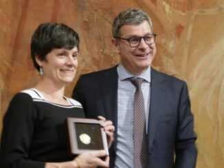
Open Geospatial Consortium bestows Gardels Award to Linda van den Brink

25 November 2019 GoGeomatics Newsmakers | CityGML

At the November meeting of the Open Geospatial Consortium (OGC) Technical Committee in Toulouse, France, Linda van den Brink received the OGC’s prestigious Kenneth D. Gardels Award. The Gardels Award is presented each year to […]

|
Newsmakers & Press Releases

CubeWerx releases new tools for geospatial analytics

14 November 2019 GoGeomatics Newsmakers | CubeWerx

CubeWerx, a leader in providing advanced geospatial web services for data providers announced the release of CubeWerx Analytics – complete usage tracking of web services down to the pixel level. “Analytics are incredibly important today”, […]

||
Newsmakers & Press Releases

Plex.Earth Timeviews™ empowers AEC professionals with the latest satellite imagery within AutoCAD

11 November 2019 GoGeomatics Newsmakers | AEC professionals

Plexscape, developers of Plex.Earth®, one of the most popular tools for AutoCAD for the acceleration of architectural, engineering and construction (AEC) projects, launched Timeviews™, a unique service in the global AEC market, which makes the […]

No Picture
Newsmakers & Press Releases

GeoSeer, A GeoSpatial Web-Services Search Engine

31 October 2019 GoGeomatics Newsmakers | GeoSeer

GeoSeer is a search engine with over 1.6 million distinct spatial datasets from over 200,000 public geospatial web services, covering Web Map Services (WMS), Web Feature Services (WFS), Web Coverage Services (WCS), and Web Map […]

|
Newsmakers & Press Releases

EUROPEAN GNSS AGENCY (GSA) AND WORLD GEOSPATIAL INDUSTRY COUNCIL (WGIC) SIGN A STRATEGIC COLLABORATION MEMORANDUM

22 October 2019 GoGeomatics Newsmakers | GNSS

STUTTGART – GERMANY, OCTOBER 17, 2019 The World Geospatial Industry Council [WGIC] and The European Global Navigation Satellite System Agency – (European GNSS Agency – GSA), signed a memorandum to collectively work towards bringing forward composite value and utility of […]

|
Newsmakers & Press Releases

GeoSeer, A GeoSpatial Web-Services Search Engine

16 October 2019 GoGeomatics Newsmakers | GeoSeer

GeoSeer is a search engine with over 1.6 million distinct spatial datasets from over 200,000 public geospatial web services, covering Web Map Services (WMS), Web Feature Services (WFS), Web Coverage Services (WCS), and Web Map […]

Newsmakers & Press Releases

New competition in Geomatics and GIS with 20,000$ in prizes for best maps

11 October 2019 Joyce McLean

Agorize and HERE Technologies launches their Mapathon Map your World!,  an online competition for everyone interested in creating maps, GIS and Geomatics. We invite all Canadians to participate in our virtual contest to make a […]

Newsmakers & Press Releases

Lethbridge College’s Geomatics program receives national accreditation

9 October 2019 Tobi Baugh

Lethbridge College’s Geomatics program receives national accreditation April 4, 2019 – Lethbridge College’s Geomatics Engineering Technology program has received national recognition. On Thursday, the Technology Accreditation Canada (TAC) presented faculty with a certificate that signifies […]

Posts pagination

« 1 … 35 36 37 … 81 »

Events

Notice
There are no upcoming events.

View All Events

Services

  • Post a Job
  • Post an Ad
  • Post an Event
  • Post a Directory Listing
  • Post a Press Release
  • Media Kit
  • My Account
  • Login

Jobs

Post a Job
  • Leader, Utilities Surveying
    Calgary, Alberta
  • Field Technicians and Field Assistants
    Saskatoon, SK
  • Earth Science / GIS / Engineering co-op
    Saskatoon, SK and Vancouver, BC
  • Senior Analyst, Geographic Information System (GIS)
    Montréal
View All Jobs
  • Directories
    • Associations Directory
    • Industry Directory
    • Education Programs
    • Open Data
  • Volunteer
    • Start a GoGeomatics Group
    • Editors & Writers Group
  • About Us
    • GoGeomatics Media Kit
    • Who We Are
    • Contact Us
    • FAQ’s
    • Advertising
    • Marketing
  • Subscribe
GoGeomatics
GoGeomatics is the largest and most popular communications hub promoting the Canadian geospatial community. The business was incorporated in 2011. GoGeomatics hosts over 100 fun, free, location technology networking events each year in cities across Canada.

© 2026 GoGeomatics

  • facebook
  • Twitter
  • Linkedin
  • Youtube
  • Linkedin Group