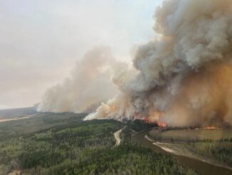
• facebook
  • Twitter
  • Linkedin
  • Youtube
  • Linkedin Group
  • Post a Job
  • Post an Ad
  • Post an Event
  • Post a Directory Listing
  • Post a Press Release
  • Media Kit
  • My Account
  • Login
GoGeomatics
  • MAGAZINE
    • BIM & GIS
    • Community
    • Conference news
    • Earth Observation
    • Education & Careers
    • GEOAI
    • Announcements
    • Reality Capture & Lidar
    • Science
    • Technology
    • Between the Poles
  • Directories
    • ASSOCIATION
    • INDUSTRY
    • EDUCATION
    • Open Data
  • EVENTS
    • GeoIgnite Events
    • Events Calendar
    • GoGeomatics Meetups
  • Services
    • Advertising
    • Marketing
    • Post a Job
    • Post an Ad
    • Post an Event
    • Post a Press Release
    • Post a Directory Listing
    • Media Kit
    • Web Design
  • Find a Job
  • Volunteer
    • Start a GoGeomatics Group
    • Editors & Writers Group
  • About Us
    • About Us
    • Contact Us
    • Frequently Asked Questions
  • Videos
HomeScience

Science

Montreal's GNSS stations
Earth Observation

Pride in Precision: Montreal’s Real-Time GNSS Network and Its Legacy

22 September 2025 Benedicta Antwi Boasiako | Canadian geodetic survey

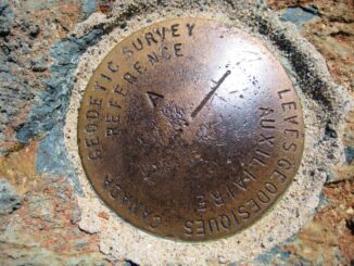
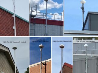
When Montréal switched on its Real-Time GNSS Network (RTN), it marked a milestone in Canadian geodesy. By deploying its own standards-compliant GNSS infrastructure, Montréal stands among the pioneering Canadian cities offering centimeter-level positioning accuracy across […]

BIM & GIS

Atomic to Tactical: DND and CAF Drive Innovation in GPS-Free Timing

18 September 2025 Farzaneh Farshad | atomic clocks

Atomic clocks have become central to the Global Navigation Satellite System (GNSS) and GPS because they are highly developed quantum sensors that enable precise timing and positioning. Defense timing today depends on GPS signal distribution, […]

Community

Compartmentalizing the Flames: A New Approach to Wildfire Management

8 September 2025 Alefiya Dungrawala | AI-model

Is wildfire spread random? It looks like that, but it isn’t. In fact, it follows the invisible geometry of landscapes: slopes, vegetation density, and wind corridors. Managing these patterns is a spatial problem. A recent […]

GEOAI

The Cooperative National Geologic Map: A Tool for Science, Safety, and Society

8 September 2025 Farzaneh Farshad | #GeospatialData

The U.S. Geological Survey (USGS) has released a new interactive web tool, The Cooperative National Geologic Map, the most detailed national-scale geologic map of the United States to date. Geologic maps serve many purposes. They […]

Digest Aug 25
Community

International Geospatial Digest – August 25, 2025

25 August 2025 Volunteer Editors and Group Writers | AI for geospatial

NOAA Upheaval Raises Concerns as U.S. Nears Peak Hurricane Season India’s Private Space Industry to Launch 12-Satellite EO Network Under PPP What’s Next for Landsat and Civilian Earth Observation Mapping the Future: Google AlphaEarth Foundations […]

Canada infra
BIM & GIS

Canada to Establish Federal Major Projects Office

25 August 2025 GoGeomatics Canada | #highways

Prime Minister Mark Carney announced last week that the federal government will establish a Federal Major Projects Office to oversee and expedite projects designated as being in the national interest under the new Building Canada […]

Earth Observation

Inside the CSRS-PPP Galileo Update: Accuracy Gains and What’s Next

20 August 2025 Benedicta Antwi Boasiako | beidou

This article includes insights from Dr. Simon Banville, Senior Advisor for GNSS Products and Analysis at Natural Resources Canada and the technical lead behind this update. Canada’s Precise Point Positioning (PPP) tool has just undergone […]

Earth Observation

True North, Magnetic North: Tracking Earth’s Wandering Pole

17 August 2025 Alefiya Dungrawala | British Geological Survey (BGS)

From the GPS in your phone to the navigation systems guiding aircraft and ships, our modern world depends on knowing exactly where “north” is. But here’s the twist — there isn’t just one north. There […]

Posts pagination

« 1 … 4 5 6 … 15 »

Events

Notice
There are no upcoming events.

View All Events

Services

  • Post a Job
  • Post an Ad
  • Post an Event
  • Post a Directory Listing
  • Post a Press Release
  • Media Kit
  • My Account
  • Login

Jobs

Post a Job
  • GIS Analyst
    Saint John, New Brunswick
  • GIS Student Intern
    Elmsdale, Nova Scotia
  • Canada Impact+ Research Chair – Professor (Or Associate Professor)
    Lethbridge, Alberta
  • Leader, Utilities Surveying
    Calgary, Alberta
View All Jobs
  • Directories
    • Associations Directory
    • Industry Directory
    • Education Programs
    • Open Data
  • Volunteer
    • Start a GoGeomatics Group
    • Editors & Writers Group
  • About Us
    • GoGeomatics Media Kit
    • Who We Are
    • Contact Us
    • FAQ’s
    • Advertising
    • Marketing
  • Subscribe
GoGeomatics
GoGeomatics is the largest and most popular communications hub promoting the Canadian geospatial community. The business was incorporated in 2011. GoGeomatics hosts over 100 fun, free, location technology networking events each year in cities across Canada.

© 2026 GoGeomatics

  • facebook
  • Twitter
  • Linkedin
  • Youtube
  • Linkedin Group