• facebook
  • Twitter
  • Linkedin
  • Youtube
  • Linkedin Group
  • Post a Job
  • Post an Ad
  • Post an Event
  • Post a Directory Listing
  • Post a Press Release
  • Media Kit
  • My Account
  • Shopping Cart
  • Login
GoGeomatics
  • MAGAZINE
    • BIM & GIS
    • Community
    • Conference news
    • Earth Observation
    • Education & Careers
    • GEOAI
    • Announcements
    • Reality Capture & Lidar
    • Science
    • Technology
    • Between the Poles
  • Directories
    • ASSOCIATION
    • INDUSTRY
    • EDUCATION
    • Open Data
  • EVENTS
    • GeoIgnite Events
    • Events Calendar
    • GoGeomatics Meetups
  • Services
    • Advertising
    • Marketing
    • Post a Job
    • Post an Ad
    • Post an Event
    • Post a Press Release
    • Post a Directory Listing
    • Media Kit
    • Web Design
  • Find a Job
  • Volunteer
    • Start a GoGeomatics Group
    • Editors & Writers Group
  • About Us
    • About Us
    • Contact Us
    • Frequently Asked Questions
  • Videos
HomeTechnology

Technology

Technology

Calgary Geography of Health and GIS Analysis: Researchers map out seasonal surprise in city air quality

7 March 2018 Michael Wood | Air Pollution

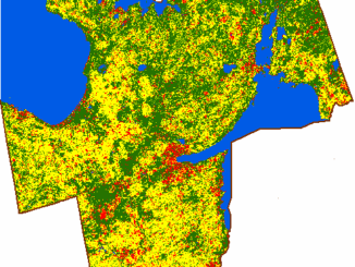
A University of Calgary study of seasonal air pollution will be of cold comfort to thousands of Calgarians living south of the Bow River: that crisp, wintry air they’re breathing in is the worst in the city. […]

Technology

Do You Care about Spatial Data and Canada’s Geospatial Data Infrastructure? If so take this survey

27 February 2018 GoGeomatics Canada | CGDI

Here’s your chance to express your needs and priorities around geospatial data and spatial data infrastructure, and help shape future activities and initiatives. In collaboration with Natural Resources Canada, Hatfield Consultants are conducting a series […]

Technology

Les 5 = ensembles de données vectorielles SIG canadiens les plus populaires

26 February 2018 Jon Murphy | CanVec

Nous parlons ici de données vectorielles SIG. Il s’agit d’une sous-catégorie des données géospatiales que le Centre canadien de cartographie et d’observation de la Terre de RNCan collecte et stocke – Les données CanVec pour […]

Figure 3: Unsupervised classification result of Simcoe County.|Figure 1: The 2005 greenbelt plan and its inner municipalities. Image courtesy of Friends of the Greenbelt Foundation.|Figure 2: Simcoe County (highlighted in mahogany) in relation to the Greater Golden Horseshoe (GGH). Image courtesy of Open Street Map.|Figure 4: Urban sprawl in the southern half of Simcoe County
Technology

Using GIS to Examine Leapfrog Development Beyond the Ontario Greenbelt

5 February 2018 Jonathan Scida | Canada

Since its establishment by the Ontario government in 2005, the Places to Grow Act is a policy envisaged at curbing the effects of urban sprawl and encouraging population growth where it is needed. According to […]

Technology

The Top 5 Most Popular Canadian GIS Vector Data Sets

11 January 2018 Jon Murphy | Canada

We’re talking GIS vector data, it’s a subset of the geospatial data that NRCan’s Canada Centre for Mapping and Earth Observation collects and stores – CanVec data to be exact. As a geomatics manager and […]

||
Technology

The Impact of Machine Learning & AI on Geomatics

6 November 2017 Ozair Khan | Artificial Intelligence

What is Machine Learning? Machine learning and Artificial Intelligence (AI) are hot areas of technology commercialization these days. So, what is machine learning? It is the ability of machines (computers) to learn like humans without […]

|Multi-Rotor Drone flying in the sky|Sunset at an airport
Technology

Five Things you Can’t Do with a UAV or Drone In Canada

2 November 2017 Murrium Zaheer | Canada

UAVs(Unmanned Aerial Vehicles) or drones are quickly becoming one of the technological wonders of the multifaceted twenty-first century. UAV’s are providing a means by which to collect efficient inexpensive information within a short period of […]

||
Community

Canada Speaks Up at UN Committee of Experts on Global Geospatial Information Management

26 September 2017 Steven Ramage | Canada

“You’ll never walk alone” I attended the seventh session of the UN Committee of Experts on Global Geospatial Information Management (UN-GGIM7) last month. It is my sixth year of involvement with UN-GGIM and with almost […]

Posts pagination

« 1 … 121 122 123 … 146 »

Events

Notice
There are no upcoming events.

View All Events

Services

  • Post a Job
  • Post an Ad
  • Post an Event
  • Post a Directory Listing
  • Post a Press Release
  • Media Kit
  • My Account
  • Shopping Cart
  • Login

Jobs

Post a Job
  • GIS Technician
    Sudbury, Ontario
  • Asset/GIS Coordinator
    Edson, AB
  • Civic Operations GIS Technologist (Permanent, Full-Time) – 1953
    Kamloops, British Columbia
  • Senior Manager, Data Science – Geospatial
    Mississauga, Ontario
View All Jobs
  • Directories
    • Associations Directory
    • Industry Directory
    • Education Programs
    • Open Data
  • Volunteer
    • Start a GoGeomatics Group
    • Editors & Writers Group
  • About Us
    • GoGeomatics Media Kit
    • Who We Are
    • Contact Us
    • FAQ’s
    • Advertising
    • Marketing
  • Subscribe
GoGeomatics
GoGeomatics is the largest and most popular communications hub promoting the Canadian geospatial community. The business was incorporated in 2011. GoGeomatics hosts over 100 fun, free, location technology networking events each year in cities across Canada.

© 2026 GoGeomatics

  • facebook
  • Twitter
  • Linkedin
  • Youtube
  • Linkedin Group