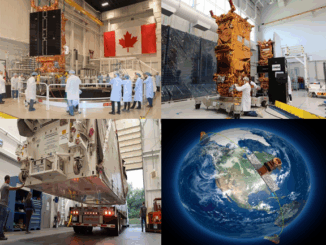
|
Technology

Canadian Geospatial Briefing Nov 15: 1. UK and Canada Space Agencies Sign MOU on Joint Activities; 2. Canadian Flood Maps; 3. Bell and ESRI Canada: Integrated Smart City Ecosystems; 4. Government of Canada Supports Canadian Satellite-Based Emissions Detection System; 5. ‘What3Words’ App in Search & Rescue

UK and Canada Space agencies sign MOU on joint activities and information sharing The UK Space Agency and the Canadian Space Agency have signed a Memorandum of Understanding on joint activities and information sharing on space, the British High […]

||||
Technology

International Geospatial Briefing Nov 8: 1. ESA Satellites to Track Greenhouse Gases; 2. Tracking Worldwide Food Insecurity; 3. Next-Generation Navigation Systems; 4. Cancer-Causing Air Pollution in the U.S.; 5. Smart Building Technology Post COVID-19; 6. Remote Monitoring of Construction Projects

European Satellite Constellation to Track Greenhouse Gas Emissions During the U.N Climate Change Conference (COP26) in Glasgow last week, the European Space Agency announced a new constellation of satellites to track human-made greenhouse gas emissions. […]

|
Technology

Canadian Geospatial Briefing Nov 1st: 1. Canadians buying homes in climate change danger zones 2. Light pollution from satellites 3. Remote Sensing benefits P.E.I. farmers 4. Ottawa’s heat map 5. Lungs delivered by drone

Canadians are unknowingly buying homes in climate change danger zones, report finds Canadians are buying homes, unaware of the areas’ high risk of flooding, wildfires and other climate change impacts. This unawareness of the risks […]

||||||
Technology

International Geospatial Briefing Oct 25th: 1. Interactive map of hidden archaeological landscapes. 2. GIS helps asylum seekers 3. Extent of California oil spill. 4. Mapping Bogota’s neighbourhoods 5. Map Tools international travel requirements 6. New York new subway map 7. GeoSLAM maps underground refugee shelter from Spanish Civil War

This Interactive Map Lets Users Explore England’s Hidden Archaeological Landscape Attention all history enthusiasts, Historic England has created a new interactive map that allows users to take a “virtual flight” over England to explore the […]