In 2015, Natural Resources Canada (NRCan) launched the National Elevation Data Strategy (NEDS), a bold initiative to modernize Canada’s landmass data foundation. Ten years later, the NEDS has become a cornerstone of Canada’s geospatial ecosystem, delivering high-resolution, accurate, and accessible 3D elevation data that supports a wide range of applications from coast to coast to coast, including natural hazard management, land-use planning, forestry inventory and infrastructure development.
Prior to the NEDS, Canada’s elevation data relied heavily on the 20-metre resolution Canadian Digital Elevation Model, with vertical accuracy varying between 5 to 50 metres. This dataset, mainly derived from topographic maps dating from 1945 to 2011, was no longer sufficient for modern applications. The emergence of airborne lidar technology offered a transformative solution, enabling centimetre-level vertical accuracy even under the canopy.
Ten Years of Elevation Innovation
Recognizing this potential, NRCan established three strategic pillars to guide the implementation of NEDS:
Expanding coverage of high-resolution elevation data using the most appropriate technologies.
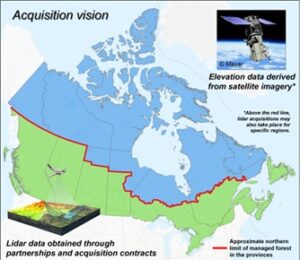
A national acquisition vision was developed, dividing the country into two main zones—south of the managed forest limit, where airborne lidar was prioritized (see green area), and north, where satellite-derived models generally met needs (see blue area). This flexible approach also allowed for targeted lidar acquisitions in northern Canada for flood mapping, forestry, and infrastructure projects.
Leveraging collaboration with all jurisdictions in the country to maximize data acquisition investments.
With several provinces and territories already engaged in lidar data acquisition, NRCan worked from the start to share existing data and coordinate new acquisitions. The Canadian Council on Geomatics provided a national forum to align priorities, promote data sharing, and support joint acquisition strategies across jurisdictions.
Improving accessibility through open data policies, open formats and user-friendly dissemination platforms.
From the very beginning, the principle of open data and open formats were central to the strategy, ensuring broad interoperability and maximizing reuse across the geospatial community.
A Decade of Impact
Since its inception, the NEDS has delivered a series of milestones that have reshaped Canada’s geospatial landscape:
- 2015: First partnerships with provinces already active in lidar data acquisition, namely New Brunswick, Nova Scotia, Quebec, and Manitoba.
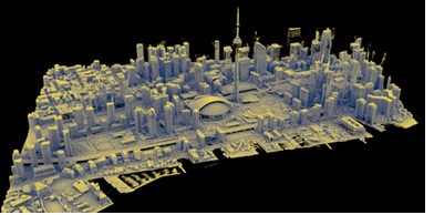
- 2017: Launch of the High-Resolution Digital Elevation Model (HRDEM), now the most downloaded geospatial dataset produced by the federal government, with over 1 million downloads per year. That same year, NRCan published the first Federal Airborne Lidar Data Acquisition Guideline and established the first Federal Supply Arrangement for lidar data acquisition, enabling the use of prequalified suppliers and streamlining large-scale data acquisition.
- 2018: First airborne lidar data acquisition under NRCan’s contract and the introduction of the Automatically Extracted Buildings product.
- 2019: Completion of high-resolution elevation in the Arctic through integration of the ArcticDEM data (version 3).
- 2020: Launch of the HRDEM Mosaic product, offering a seamless and harmonized representation of existing high-resolution elevation data.
- 2021: First topo-bathymetric lidar acquisition contract managed by NRCan and the launch of the Flood Hazard Identification and Mapping Program (FHIMP) led by NRCan. This program accelerates the acquisition of lidar data for flood mapping in areas at high-risk of flooding.
- 2023: Launch of the Lidar Point Clouds product, providing download and streaming access to open lidar data integrated in the NEDS. That same year, achievement of 1 million km² of coverage in the HRDEM product.
- 2024: Launch of the Medium-Resolution Digital Elevation Model (MRDEM) product, a national geospatial dataset optimized for regional and national-scale applications, complementing the HRDEM used for more detailed analyses.
- 2025: Official migration of the Federal Airborne Lidar Data Acquisition Guideline into a recognized National Standard of Canada. This year, the HRDEM coverage reached 2 million km², and a complete update of the Canadian Arctic HRDEM data was performed, using ArcticDEM version 4.1.
National Reach, Local Relevance
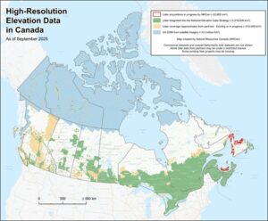
Today, the NEDS supports five national open data products, including the HRDEM and HRDEM Mosaic, which are endorsed by the CCOG. Over 2 million square kilometres of lidar data and 4.5 million square kilometres of satellite-derived elevation data have been integrated, covering the territory where approximately 95% of the Canadian population lives.
The strategy has also enabled the automatic extraction and dissemination of over 13.6 million building footprints, generated from lidar data. It also supports emerging initiatives like the Canadian Hydrospatial Network (CHN), a next-generation hydrographic product currently under production that leverages airborne lidar-derived elevation data.
These efforts enhance the production of high-precision integrated datasets which underpin critical work in flood mapping, urban planning, forest inventory, infrastructure development, and environmental monitoring.
What’s New with the National Products of the Strategy?
Lidar-derived DEMs
Since the last Newsletter in October 2024, over 475,000 km² of lidar-derived digital elevation models have been added to the HRDEM and HRDEM Mosaic products—an increase of 31% in just over a year. This brings the total coverage of HRDEM data derived from lidar to more than 2 million km². The new data added largely covers regions that previously lacked lidar coverage in national products.
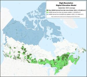
These additions now extend coverage to 244 of the country’s 250 largest cities and more than 95% of the Canadian population—approximately 39.6 million Canadians. Several populated areas have also been updated using more recent lidar data, including the Greater Toronto Area and the Montreal Metropolitan Community.
The lidar data comes from a wide range of partners across the country, as well as acquisitions made by Natural Resources Canada (NRCan), supported by funding from the Flood Hazard Identification and Mapping Program (FHIMP).
Satellite imagery-derived DEMs
A complete update of the Northern HRDEM data was recently completed using the latest version of ArcticDEM data (version 4.1 Mosaic). This new version corrects the vast majority of problems visible in the previous Northern data, particularly artifacts and data voids mainly located in mountainous and/or forested areas. The data has been transformed to comply with Canadian standards. This update also increases coverage south of the 60th parallel and northwestern British Columbia, bringing the total area of HRDEM derived from satellite imagery to approximately 4.5 million km².
Note: The ArcticDEM v4.1 data used are provided by the Polar Geospatial Center, with support from NSF-OPP grants 1043681, 1559691, 1542736, 1810976, and 2129685
Buildings automatically extracted from lidar data
Since October 2024, 1.2 million new building footprints have been added to the Automatically Extracted Buildings product, generated from lidar data. These new additions plan span several provinces and territories, including Ontario, Quebec, Saskatchewan, Alberta, British Columbia, Newfoundland and Labrador, Yukon, and Nunavut. The product now includes over 13.6 million building footprints.
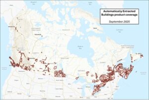
Building footprints derived from lidar data are valuable for many analyses, as they are spatially aligned with lidar data and include the minimum and maximum elevation values of each building.
Lidar point clouds product
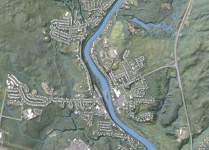
More than 141,540 km² of data has been added to the Lidar Point Clouds product, bringing total coverage to 363,946 km². This new data is located across British Columbia, Alberta, Saskatchewan, Manitoba, Ontario, Quebec, New Brunswick, Nova Scotia, Prince Edward Island, Newfoundland and Labrador, and Nunavut. Of note, lidar data acquired in 2023 and 2024 now covers the entire Greater Toronto Area and the Montreal Metropolitan Community.
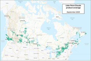
Several of these additions were made possible by the FHIMP, including topographic and topo-bathymetric lidar data in flood-prone areas. The additions include projects carried out by NRCan or by partners across the country.
Acquisition Status (2021–2025) in Support of the FHIMP
The National Elevation Data Strategy team at NRCan, whose aim is to make accurate, high-resolution elevation data available across the country, plays a key role in the Flood Hazard Identification and Mapping Program (FHIMP). The team contributes its expertise to the program, particularly in lidar data acquisition, quality control and the development of derived products. These data and products play a fundamental role in flood hazard mapping and regional flood modelling in high-risk areas across the country.
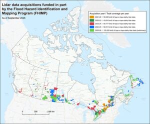
Since the program was launched, the provinces, territories and NRCan’s strategy team have been working closely together to acquire this lidar data. This year, 26 lidar data acquisition projects are planned. Including acquisitions planned for 2025, a total of 97 lidar projects will have been funded by the program over five years, covering an area of 367,747 km². All acquired data are integrated into the five core products of the National Elevation Data Strategy.
Conclusion
As Canada continues to face complex challenges, from climate resilience and sustainable resource management to infrastructure modernization and national security, the importance of reliable elevation data will only grow. The NEDS is constantly evolving and is expected to significantly expand its coverage in the coming years. According to current estimates, by 2030, more than 1.3 million square kilometers of additional lidar data will be collected in previously uncovered areas, along with updates to several locations that already have lidar coverage. This expansion will result in more than 72% of the country being covered by high-resolution elevation data, including 3 million square kilometres (or 30% of the country) of lidar data.
The success of NEDS over the past decade reflects a national commitment to innovation, collaboration, and open data. With strong partnerships and a clear vision, NRCan and its partners are well-positioned to build on this foundation for years to come.
Authors:
David Bélanger
Olivia Dubois
Xavier Gallagher-Duval
Charles Papasodoro
Jean-François Rouleau


Be the first to comment