
The Greater Montréal Area completed Canada’s largest-ever riverine topobathymetric lidar survey in
response to two major flooding events within the last five years, which together displaced tens of
thousands from their homes and cost millions to local and regional governments. The survey, which
encompassed 1,000 flight lines and a flown length of 10,000 kilometers, will better inform the region’s flood modeling to lower the human and economic costs of future events.
Over the past five years, the Greater Montréal Area has experienced multiple significant flooding events.
United within the Communauté Métropolitaine de Montréal (CMM), the Greater Montréal Area brings
together 82 municipalities, 4,374 square kilometers, and a population of more than four million people.
Located at the convergence point of the Saint Lawrence and Ottawa rivers and with more than 900
kilometers of linear shoreline, Montréal is at significant risk from flooding during periods of heavy
precipitation.
In May 2017, widespread flooding caused by heavy rain and snowfall affected communities throughout
southern Quebec. More than 4,000 people were displaced from their homes, and the affected
municipalities declared a state of emergency as communities on the Island of Montreal were impacted by
rising water from the Rivière des Prairies.
In 2019, flooding returned and nearly matched the damage experience two years earlier. In both events,
the government of Quebec’s hydrologic and hydraulic modeling proved inadequate for effective
preparation. Hydrologic modeling predicts the Earth’s natural water movement, while hydraulic modeling
specifically predicts the flow of fluids in specific circumstances. As a result of flooding events in both 2017
and 2019, the government of Quebec mandated the CMM with updating the current flood risk maps for
the Greater Montreal Region. The CMM’s early attempts at hydraulic modeling revealed a lack of
precision in shoreline and bathymetric areas needed to properly calibrate the models. This in turn led the
CMM to conduct a topographic lidar survey in 2018 and a topobathymetric lidar survey in 2020.

Topobathymetric lidar for improved flood planning
The 2019 flooding, and its costly effect on the Greater Montréal Area, put greater emphasis and urgency
on the need to produce a more accurate method for predicting and evaluating flood risks. One key
shortfall of the region’s existing surveys was the use of topographic lidar, which does not penetrate the
surface of the water and is less useful for hydraulic modeling. The CMM recognized the need for additional
surveys: shoreline mapping is key to producing a high-resolution hydraulic model, with increased
accuracy required to effectively merge data between surface topography, riverbank morphology and
watercourse bathymetry.
NV5 Geospatial, formerly known as Quantum Spatial Canada, has an extensive background in complex,
large-scale data acquisition projects. The company is specifically experienced in coastal lidar,
topobathymetric surveys and data analysis, having completed projects throughout the United States and
Canada for organizations including GeoBC in British Columbia, in addition to complex US government
projects with the Commonwealth of Massachusetts and the National Oceanic and Atmospheric
Administration (NOAA).
The CMM commissioned NV5 Geospatial to conduct aerial topobathymetric lidar surveys of the region’s
28 main watercourses, with the goal of updating flood zone mapping and creating an online tool to warn
citizens of incoming flooding using high-precision water flow modeling and real-time water level
measurements.
Due to the size of the area and the significant number of watercourses to be measured, the data
requested by the CMM represented one of the largest riverine aerial topobathymetric surveys ever
undertaken in Canada. Topobathymetric surveys also present unique challenges with regard to data
acquisition. The weather conditions must meet a series of parameters: cold enough for leaves to have fallen from the trees, but not too cold for snow to have fallen, and with minimal wind to ensure water
clarity. During the fall season in Montréal, these types of days cannot be taken for granted.
Precise, thorough and well-coordinated
NV5 Geospatial committed to taking advantage of every suitable day during Fall 2020 to ensure on-time
delivery of the collected data. With no margin for error, data acquisition required effective coordination
with local Air Traffic Control (ATC) organizations, as well as efficient project management and frequent
communication with CMM stakeholders. NV5 Geospatial worked together with KASI Aviation to conduct
the aerial surveys, leaning on the local flight operations specialists for their relationships with ATC groups.
NV5 Geospatial also deployed its INSITE Project Management Tracker to consolidate project information
and communicate key updates to CMM partners in real-time.
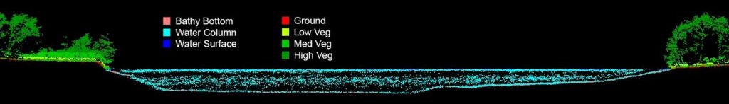
The topobathymetric lidar survey took place in October and November 2020, using the Leica Chiroptera
4X / Leica HawkEye 4X system. This advanced sensor system delivers denser data than traditional
bathymetric lidar systems, helping to meet the requirements of the CMM by simultaneously acquiring
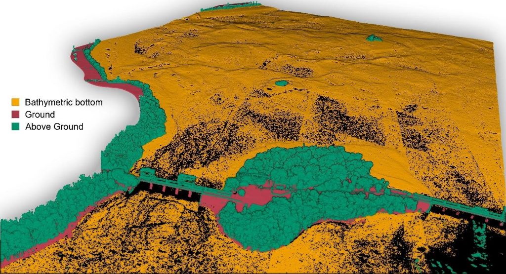
shallow bathymetric lidar, deep bathymetric lidar, and topographic lidar. The sensor provides seamless
coverage from land to below water and offers full waveform capture in both channels.
NV5 Geospatial completed the data acquisition on time over the course of 43 flight missions. The survey
consisted of more than 1,000 flight lines with a total length of over 10,000 kilometers. Additionally, the
associated ground survey included more than 100 ground control points, 40 quality assurance points,
over 65 water clarity samples, and hundreds of bathymetry check points. The breadth and nuance of
these surveys resulted in a dataset comprising nearly 5,000 data swaths and four terabytes of
information.
Results
Following an exhaustive process of cleaning and analyzing the massive dataset collected in Fall 2020,
NV5 Geospatial delivered the collected data on schedule in late April 2021. The CMM worked in
collaboration with NV5 Geospatial to provide additional quality control and insight to ensure the highest
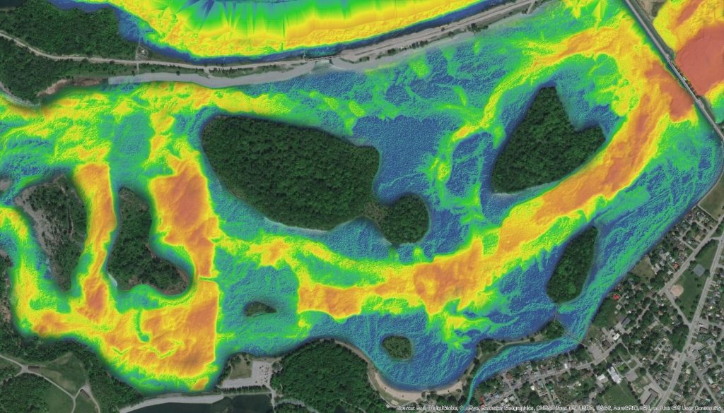
quality deliverables given the unique constraints of the project. Covering nearly 1,000 kilometers of
shoreline, the rich, clear and nuanced data will lead to key improvements in the accuracy and utility of
high-resolution hydraulic and hydrologic models.
“The CMM was very pleased that NV5 Geospatial won the public call for tenders process, as it soon
became obvious that their extensive experience with topobathymetric lidar and large-scale data
acquisition projects would be invaluable to the success of this ambitious project,” said Guillaume Spain,
geomatic analyst at the Communauté Métropolitaine de Montréal. “The complicated acquisition phase
was completed without a hitch, and the extensive data products delivered by NV5 Geospatial exceeded
our expectations. This data will prove a tremendous asset as we aim to mitigate the effects of climate
change and prepare for future flooding events.”
The exceptional accuracy of the topobathymetric lidar data collected and processed by NV5 Geospatial
will serve the CMM well in the coming years, as they leverage the collected data to improve local flood
resilience. As more and more communities across North America are affected by natural disasters,
proactive data analysis will be crucial to mitigate the economic and human costs of climate change.
About NV5 Geospatial
NV5 Geospatial, powered by Quantum Spatial, is North America’s largest provider of geospatial services,
providing end-to-end solutions and insights to organizations that need geospatial intelligence to mitigate
risk, plan for growth, better manage resources and advance scientific understanding. We combine the
widest array of advanced remote sensing technologies with proprietary processes, analytics tools,
algorithms, and analysis tailored to meet our clients’ needs. For more information, visit
quantumspatial.com, join us on LinkedIn, or follow us on Twitter @nv5geospatial.


Be the first to comment