
Digital Sovereignty is becoming an increasingly important topic for Canadians. Not only is Canada falling behind by lacking infrastructure and using overseas data centres to house crucial information, but it seems like the rest of the world has already figured out the solutions to this problem well before we have even started to discuss it.
GoGeomatics is currently focusing on this topic, and this article will look into the best ways to bring this information more into the public eye with discussions.
This article in particular will focus on the infrastructure needed to facilitate the needs of making local Canadian digital sovereignty a reality. By identifying the right infrastructure and the most strategic locations to build it, we can ensure that Canada’s digital foundation is both resilient and sovereign.
In order to best start these kinds of projects, the best point of interest would be existing infrastructure, i.e. electric power plants, natural gas sites, or other energy centers with available nearby land.

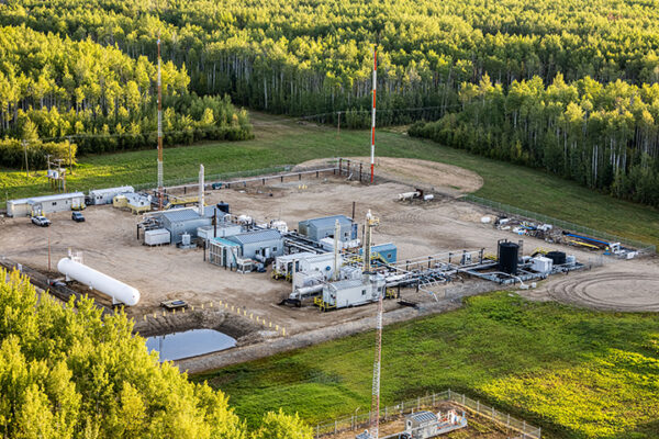
An example of this is already in development in Greenview No. 16 municipality, Alberta, South of Greenview Industrial Gateway in Grande Prairie. The Wonder Valley AI Data Centre Park is in phase one of development. Although labelled as an AI data center, having a data hub in a predominately energy focused location, as well as in a colder climate, makes this an excellent example of establishing infrastructure for Digital Sovereignty in Canada. Greenview No. 16 municipality has a well established infrastructure involving natural gas, meaning that optimized locations will have existing natural gas and power lines prior to development, making the overall process easier at the beginning stages. Canada has an ideal climate and energy resources that can promote the infrastructure without the constant need of resource based coolants such as water. Between Northern locations and high altitude mountainous regions, all that’s left is to establish these data centres in locations with existing infrastructure to support these data centres.
Building these centers won’t be easy; the push for new data hubs is competing with an aging national infrastructure that is already due for a massive overhaul. Most of Canada’s infrastructure is at an age where there is a great need for repairs due to the historical rapid expansion. Cities like Grande Prairie and Fort Saint John will become the new Gateways to the North with increasing populations and available development labour jobs.
In addition to this, these Northern regions are under-developed in terms of existing infrastructure. This means that Canada will need to build new roads and electrical grids just to establish these data centres.
Geospatial Technology is at the centre of this growth. With all these infrastructure demands, GIS and Surveying will be in heavy demand to even get these projects started. (We have to build the road first if we want the best location).
Canadian field workers have also proven time and time again that they are masters of ingenuity, cross discipline teamwork, and hard work. Construction, Forestry, Oil and Gas, and Mining all utilize people from several different disciplines. Engineers, Environmental Techs, Foresters, Geologists, Data Analysts, and Surveyors all work together for common goals in the previously listed industries, and building these data centers for Canadian Digital Sovereignty should be a beneficial venture for everyone involved and help secure Canada’s Data independence.
Additionally, we can use Scandinavian countries as a reference for what to do and what not to do. Much like Canada, Denmark, Norway, and Sweden all have similar physical geography, climate, and population dynamics that are spread out. However, the main issue with Canada’s expansion has always been how far away everything is, which makes any development timing difficult.
The intersection of digital sovereignty and physical infrastructure is a complex, multi-faceted challenge. GoGeomatics will continue to explore these themes in upcoming articles as we track how Canada’s geospatial and energy sectors converge to secure our data independence.


Be the first to comment