
The protection of the environment and wildlife is not merely a moral imperative but a critical necessity for sustaining life on Earth. As human activity accelerates climate change, habitat destruction, and species extinction, the balance of natural ecosystems is being pushed to the brink.
Amidst these developments, Prince Edward Island‘s Environmental Protection Act safeguards its dunes, wetlands, streams, and their buffer zones. P.E.I.’s provincial Department of Environment has recently launched an updated version of a mapping tool that enables islanders to identify areas where development cannot occur due to environmental concerns.
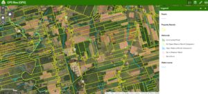
The Potential Development Restrictions map, along with a checklist and additional information, now serves to determine whether the mapped areas are accurately represented. This new tool is based on the Wetland Inventory Map, which is updated regularly.
The Department of Environment has made a significant move in response to the rapid development of rural areas that were previously classified as wooded or cultivated land. The purpose of creating the mapping tool is to increase awareness among those involved in land development. They can contact the department to request a land assessment to determine whether it contains sensitive environmental features that need protection from development.
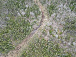
Furthermore, safeguarding wetlands and watercourses helps mitigate the risk of flooding, which is occurring more frequently than ever before.
Land inspections are typically conducted between June and September. During this peak growing season, vegetation and hydrology can be assessed over two to eight weeks.
When a developer acquires a property that includes a buffer zone or wetland, that specific area is restricted from development; other portions of the site may be developed strategically.
It is anticipated that this tool will help developers and property owners adopt a more environmentally conscious approach, thereby contributing to the preservation of wildlife, their habitats, and endangered species, ultimately promoting the sustainability of the ecosystems.


Be the first to comment