It has been well over two years since the launch of Canada’s most recent space mission, the RADARSAT Constellation Mission (RCM).
Now is a time look at the history, specifications, and applications of this remarkable project. The project represents an investment of of over 1 billion Canadian Dollars, according to spacenews [1] and teslarati [2] released in 2012 and 2019, respectively
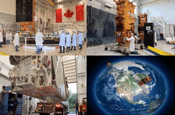
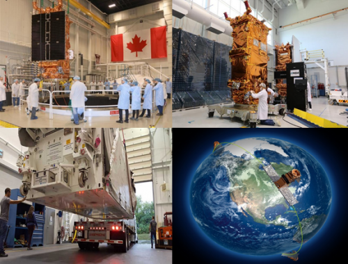
The RCM satellites were built by MacDonald, Dettwiler and Associates Ltd. (now MDA) as the prime contractor in collaboration with the Canadian Space Agency (CSA) and launched from the California Air Force Base on June 12, 2019 (Figure 1). The operation of satellites, as well as ground stations, are under the control of CSA, while the Government of Canada has the ownership of the collected data, and the Department of National Defense (DND) is responsible for data ordering, processing, and reception [Doyon et al., 2018].
The History of RADARSAT in Canada
Collecting data for large-scale studies of the Earth in a short amount of time persuaded the scientist to build and launch Earth Observation (EO) satellites starting with “Sputnik 1” on October 4, 1957.
Canada first launched RADARSAT-1 on November 4, 1995, in a collaboration between CSA as an owner and operator, and NASA as a launcher. The success of RADARASAT-1 in different applications such as ice, ocean, and environmental monitoring, as well as off-shore surveillance encouraged the Government of Canada to continue its space missions with the development of RADARASAT-2. Launched on December 14, 2007, RADARSAT-2 was the most successful commercial EO radar satellite at that time with vast applications from ice/ocean monitoring to disaster management and marine surveillance, which kept Canada as a leader in radar space missions. RADARSAT-2 was a jointly funded project between the Government (CSA) and the industry (MDA). The project started in February 1998, when CSA awarded a contract to MDA to build RADARSAT-2. This satellite had some advanced characteristics in comparison to its first release RADARSAT-1, such as extended polarimetric capabilities (HH for RADARSAT-1 vs. full-polarimetric option for RADARSAT-2), as well as higher spatial resolution. RADARSAT-2 has provided continued radar data capturing and it is still operating beyond its designed 7 years life span.
These two successful projects led the government of Canada to expand and even elevate space radar capabilities through the announcement of the next generation RADARSAT Constellation Mission in 2004. The RCM project took 15 years to complete: eight years for the definition phase; and, seven years for the build and launch phase.
What is the RADARSAT Constellation Mission?
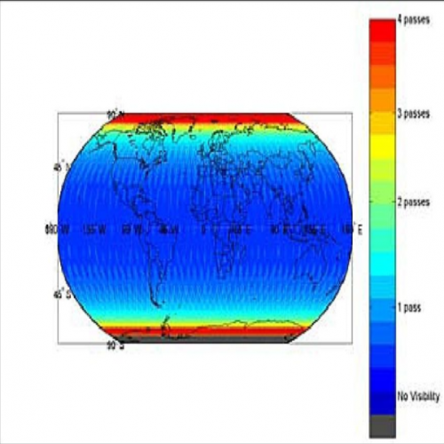
The RCM is a constellation of three identical satellites (Figure 2). It is referred to as a “constellation” since the group of satellites work together as a system to have near-global coverage through increasing the revisit time. The RCM average daily coverage of Canada as well as daily access to 95% of the world are shown in Figure 3. This is Canada’s highest resolution satellite, and in future, the RCM mission might be upgraded to include an additional three satellites (i.e., six satellites in total).
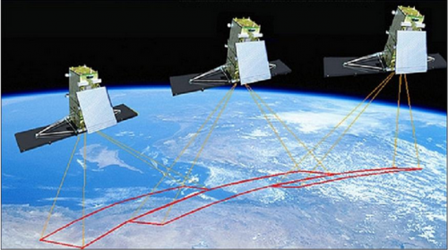
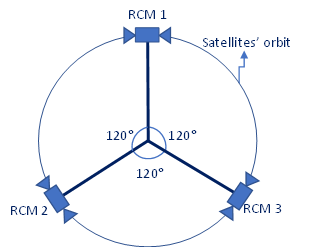
Figure 2. A) the RCM imaging concept (image credit: MDA, CSA), B) the RCM constellation of three identical same orbit satellites
How does the RCM work?
The satellites are generally either active or passive sensors. Passive sensors depend on the sun as the illumination source since they sense the radiated electromagnetic energy from surfaces. They can work in different parts of the electromagnetic spectrum such as visible (RGB), thermal, infrared, or SWIR. Optical satellites such as Worldview 1/2, GeoEye 1/2, and Sentinel-2 are all passive examples. In contrast, active sensors have their own source of energy, which causes some special advantages in comparison to passive sensors. They operate in the microwave portion of the spectrum, which is a part of the atmospheric window. Atmospheric windows are referring to those parts of the electromagnetic spectrum that has the least amount of signal degradation due to weather conditions/cloud coverage. Some advantages comparing passive sensors include operating in day/night and approximately in all-weather conditions or cloud coverages, the possibility to control the beam/signal, penetration capability, and providing valuable information about the structure, orientation, water content, and roughness of the objects. Active sensors also work in different frequencies of microwave including P, L, C, X, K, Ka, or Ku-band. RADARSAT 1/2 and the RCM are all working in C-band. Besides all the advantages, microwave sensors face some shortcomings as well. Difficulty in data interpretation, as well as geometric distortions, are some examples, although new methods have continuously been introduced to solve these difficulties.
What are the specifications of the RCM?
The RCM satellites are in a class of low-earth, low-weight satellites, and operate in a sun-synchronous orbit to pass every point on the earth at a fixed local solar time (i.e., 10:30 am). Additionally, the three satellites of the RCM are positioned in the same orbit and are approximately 32 minutes (120°) apart from each other to have the most coverage (Figure 2). The satellites are designed to have a life span of 7 years.
Since RADARSAT-2 was the most successful radar satellite in Canada, some of the major differences between the RCM and RADARSAT-2 are summarized in Table 1. For the full description of the RCM/RADARSAT-2 characteristics, readers are referred to the EOPortal website [3]. In addition to the common capabilities of radar sensors including Interferometric SAR (InSAR), Differential Interferometric SAR (DInSAR), Polarimetric SAR (PolSAR), and Interferometric Polarimetric SAR (PolInSAR), the RCM has the possibility to collect extremely small changes through Coherent Change Detection (CCD). The Circular transmitting capability to collect Compact Polarimetric data (i.e., RV, RH, LV, and LH) is another state-of-the-art capability of the RCM in comparison to RADARSAT-2.

Why is the RCM so useful?
An extensive collection of capabilities makes the RCM project exclusive and profitable. For example, the unique characteristics of the RCM make it very optimal and useful. These characteristics include high spatial and temporal resolutions, system reliability, high coverage (around 95% of the world), as well as some new components in comparison to RADARSAT-2 (e.g., full-compact polarization, first-ever used circular transmitted polarization, a constellation of three identical same-orbit satellites).
Additionally, the uses of the RCM are categorized into three principal classes as follows:
- maritime and national surveillance/security – which covers a broad area
sof applications including ice/iceberg monitoring, ship detection, and oil pollution monitoring. - environmental monitoring and conservation.
- disaster management – which includes a warning, response, and recovery.
The main users of these classes include DND, Department of Fisheries and Ocean (DFO), Agriculture and Agri-Food Canada (AAFC), Environment and Climate Change Canada (ECCC), Canadian Ice Service (CIS), Canadian Coast Guard, Transport Canada, Indigenous Services Canada (ISC), Natural Resources Canada (NRCan), Public Safety Canada, and Parks Canada (Figure 4).

Among different users, CIS and DND require RCM data for operational and real-time safe and secure maritime-related applications. Some examples include:
- the continuous supervision of threatening activities in the Arctic and remote areas.
- ship tracking to assess potential illegal activities as well as navigational safety.
- oil spill detection and tracking.
- evaluating the hazardous rate of icebergs for maritime applications.
- offshore oil and gas platforms safety monitoring.
According to [Manore et al., 2010; Geldsetzer et al., 2015; and Dabboor et al., 2018], the preliminary assessments using simulated data have shown the high potential of the RCM data in the desired planned applications such as ice/snow, oil, and wind studies. However, more investigations should be conducted to figure out all capabilities. Forecasting marine noise level that is a concern for marine animal communication (e.g., whales), infrastructural monitoring, and helping northern communities with safer travel, fishing, and hunting are some of the examples for potential applications.
Conclusion
The historic success of RADARSAT-1 & 2 to collect valuable data for different users in Canada and other countries was the primary reason to design and build a new generation of SAR satellites, called the RCM. The state-of-the-art characteristics of the RCM such as the constellation of three identical same-orbit Canadian satellites for a near-global coverage, circular transmission (compact polarimetry), improving system reliability, Coherent Change Detection (CCD) capability, higher spatial resolution, and lower revisit time are some superiorities of the RCM in comparison to RADARSAT 1 and 2. Additionally, it maintains Canada’s position at the forefront of EO radar satellite technologies to ensure SAR data continuity for the current and even more potential users. It can boost the safety and security of Canadians operationally in different aspects of maritime surveillance (e.g., ice mapping and ship detection) and environmental conservation (e.g., forest and permafrost monitoring). It is also a powerful tool for disaster management and decision support systems in different Governmental departments.
References
- https://spacenews.com/canadian-radarsat-constellation-mission-delayed-cost-rises-400m/
- https://www.teslarati.com/spacex-readies-falcon-9-radarsat-california-launch/
- https://directory.eoportal.org/web/eoportal/satellite-missions/r/rcm
- https://mdacorporation.com/
- https://www.asc-csa.gc.ca/
- https://pdfs.semanticscholar.org/ee98/5fe866adcae5c7bc03355415b4e67aef9ce7.pdf
- Manore, M., DeAbreu, R., Zabeline, V., Arkett, M. and Bradley, D., 2010. The RADARSAT Constellation Mission (RCM): Extending operational marine surveillance for environment Canada. In Proc. ASTRO Annu. Meeting (pp. 1-6).
- Geldsetzer, T., Arkett, M., Zagon, T., Charbonneau, F., Yackel, J.J. and Scharien, R.K., 2015. All-season compact-polarimetry C-band SAR observations of sea ice. Canadian Journal of Remote Sensing, 41(5), pp.485-504.
- Dabboor, M., Montpetit, B. and Howell, S., 2018. Assessment of the high resolution SAR mode of the RADARSAT constellation mission for first year ice and multiyear ice characterization. Remote Sensing, 10(4), p.594.
- Doyon, M., Smyth, J., Kroupnik, G., Carrié, C., Sauvageau, M., Lévesque, J.F., Babiker, F., Abbasi, V., Giguère, C., Bergeron, J., and Côté, S., 2018. RADARSAT CONSTELLATION MISSION: Toward launch and operations, SpaceOps Conferences, 28 May – 1 June 2018, Marseille, France.


Be the first to comment