
“Today we’re launching a new AI model, AlphaEarth Foundations, to help understand our planet in magnificent detail,” Google announced.
In recent years, monitoring Earth’s landscapes has become increasingly crucial for tackling global issues like food security, climate change, deforestation, urban growth, and water management. Thanks to rapid technological progress, artificial intelligence—especially deep learning—has become a powerful means to improve the accuracy and efficiency of environmental observation. AI-based methods now outperform traditional techniques by quickly and precisely analyzing large and complex datasets far faster than humans can.
In this regard, Google has introduced a groundbreaking AI model capable of processing petabytes of Earth observation data to produce a comprehensive, high-resolution representation of the planet. This breakthrough represents a major advancement in global mapping and the future of environmental monitoring.
Let’s see what it is all about.
What is AlphaEarth Foundations?
AlphaEarth Foundations is an AI-driven system that differs from traditional satellites, which orbit the Earth for days, covering different regions but often leaving gaps.
AlphaEarth integrates diverse data sources, including satellite images like Sentinel-2 and Landsat, radar, LiDAR 3D mapping, digital elevation models, environmental data, and geotagged and contextual information. Knitting together this information, the model analyzes the world’s landscape and coastal waters in precise 10-meter squares. This granular approach enables the monitoring of temporal changes with exceptional precision.
As a virtual satellite, AlphaEarth fills the missing data gaps left by conventional methods. Ultimately, it provides a current, detailed summary even for remote areas often obscured by clouds. This approach streamlines the management of data from various satellite systems, continuously providing an updated view of the world.
But what exactly makes AlphaEarth so accurate and resource-efficient? The answer lies in its innovative framework and novel geospatial embedding system.
Compact, Efficient, and Accurate
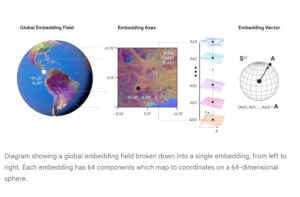
The Alpha Earth Foundation is founded on a geospatial embedding framework known as “Space Time Precision” (STP). This architecture is engineered to detect both nuanced details and prominent patterns within the spatial-temporal matrix.
A key characteristic of this model is its ability to process data efficiently. It encodes observations into a 64-dimensional vector, thereby decreasing storage demands by a factor of sixteen relative to earlier systems. For example, it is like compressing a full-resolution image into a thumbnail without losing key details.
This enhanced efficiency significantly facilitates the feasibility and cost-effectiveness of conducting analyses at a planetary scale.
The model possesses the capability to concurrently process spatial, temporal, and resolution-related information. Employing self-supervised and contrastive learning techniques, the artificial intelligence system reconstructs and forecasts missing data points, thereby enhancing its robustness in managing incomplete or noisy datasets. Also, less storage than that generated by other tested AI systems, greatly reducing the expense of large-scale planetary analysis.
Furthermore, the integration of a dual-model training paradigm promotes effective synergy, ensuring dependable performance even in circumstances where input data sources are partially unavailable.
Mapping with Virtual Satellite for Earth
- This marks a major advancement in Earth mapping. The AlphaEarth Foundation offers improved accuracy, higher precision, and greater resolution, capturing subtle pattern changes often missed by traditional methods.
- It interpolates and extrapolates missing data to produce comprehensive maps for specified date ranges. AlphaEarth has surpassed expert-tuned models across various tasks, including land use classification, crop identification, forest monitoring, and surface property estimation.
- It can fill gaps in historical data, deepening our understanding of the past. With a 24% reduction in error rates, it performs well even in low-angle shot scenarios where labeled features are scarce.
- Additionally, AlphaEarth can generate maps in poor environmental conditions by leveraging its multi-source training, which integrates information from around the globe.
Access and Use Cases
- AlphaEarth is openly accessible to the public. The annual “Satellite Embedding dataset,” derived from the AlphaEarth Foundations, is hosted on Google Earth Engine.
- This availability alleviates the challenges associated with managing complex artificial intelligence models and performing computationally intensive tasks independently. Consequently, this advanced Earth observation resource is accessible to developing countries requiring precise data, local governments, organizations of varying sizes, researchers, and stakeholders across both private and public sectors.
- Notably, AlphaEarth has been evaluated by more than 50 organizations worldwide.
- For instance, MapBiomas employed AlphaEarth for environmental monitoring purposes, including the detection of deforestation in the Amazon rainforest, successfully identifying instances of illegal logging.
- Another significant application is the Global Ecosystems Atlas, which leverages this tool to map terrestrial ecosystems by classifying remote deserts and coastal regions.
- Additionally, the United Nations Food and Agriculture Organization has utilized AlphaEarth for agricultural monitoring initiatives.
Limitation and Risks
The AlphaEarth Foundation model represents a cutting-edge technological breakthrough in earth mapping. However, it relies heavily on high-quality satellite data. While it is known for effectively filling gaps in missing or incomplete data, interpreting poor-quality inputs in critical situations can lead to misdirection.
Additionally, its dependence on cloud platforms may limit adoption in regions with inadequate digital infrastructure. As the platform is openly accessible to researchers and policymakers, issues of data privacy and sovereignty must also be carefully considered.


Be the first to comment