ArcticDEM
NATIONAL ELEVATION DATA STRATEGY UPDATE
July 2020 STATUS OF THE LIDAR ACQUISITIONS The National Elevation Data Strategy team of the Canadian Centre for Mapping and…
CANADA’S NATIONAL ELEVATION DATA STRATEGY UPDATE
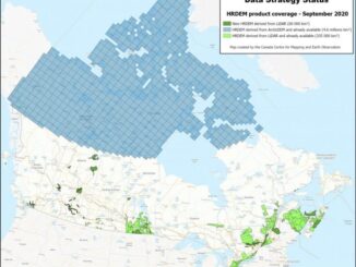
November 2019 HRDEM FOR THE ENTIRE CANADIAN ARCTIC! In August, Natural Resources Canada (NRCan) made available a new release of the High…
Urthecast, Maxar, Climate Atlas, Hybrid GIS, ArcticDEM: Your Monday Briefing
In the news: Climate data and those who can access it, LiDar mapping at work in the Okanagan, and Business…
La révolution des données d’élévation du CCCOT, partie 2: ArcticDEM
Avec une superficie de plus de 4 millions de km² au nord du 60e parallèle, le Canada possède une des…
CCMEO’s Elevation Data Revolution: Part 2 – ArcticDEM development
With more than 4 million km² of land above the 60th parallel, Canada has one of the largest Arctic regions…