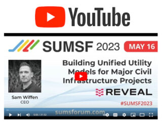
||
Technology

International Geospatial Briefing July 12th, 2021: Mapping the hot hotspots in the world; Esri’s book calling for action for conservation; June ArcGIS Living Atlas Updates; Telecomm giant maps climate resilience; Map the graveyards and trace you family tree; LiDAR to stop texting and driving; Digital Twin of the News

Mapping the hottest temperatures around the world June was an exceptionally hot month for several countries in the northern hemisphere. A “heat dome”, where high pressure traps the heat, is being blamed for the excessively high […]

|||||
Technology

International Geospatial Briefing June 14th, 2021: Study of Australian Land Ownership; Drone thermal mapping for emergency response; Combination of Digital Twins and GIS; The map of the online world; Vaccine distributions across the world

Australian Land Ownership The ownership of Australian land can be dated back to 60,000 years ago, however, the modern legal system makes the situation more complicated with titles such as freehold, crown leases, native title, […]

|||||
Community

International Geospatial briefing for 30th November: Mapping the Ocean floor; Geospatial COVID-19 Vaccine distribution; Sydney beaches drone monitoring; UK Map sales soar; Software without Geospatial power has lost the plot.

Which Countries are Mapping the Ocean Floor? Significant progress has been made in Earth Observation around the world. Thousands of satellites currently observe our planet; about three-quarters of the Earth’s surface is influenced by human […]