• facebook
  • Twitter
  • Linkedin
  • Youtube
  • Linkedin Group
  • Post a Job
  • Post an Ad
  • Post an Event
  • Post a Directory Listing
  • Post a Press Release
  • Media Kit
  • My Account
  • Login
GoGeomatics
  • MAGAZINE
    • BIM & GIS
    • Community
    • Conference news
    • Earth Observation
    • Education & Careers
    • GEOAI
    • Announcements
    • Reality Capture & Lidar
    • Science
    • Technology
  • Directories
    • ASSOCIATION
    • INDUSTRY
    • EDUCATION
    • Open Data
  • EVENTS
    • GeoIgnite Events
    • Events Calendar
    • GoGeomatics Meetups
  • Services
    • Advertising
    • Marketing
    • Post a Job
    • Post an Ad
    • Post an Event
    • Post a Press Release
    • Post a Directory Listing
    • Media Kit
    • Web Design
  • Find a Job
  • Volunteer
    • Start a GoGeomatics Group
    • Editors & Writers Group
  • About Us
    • About Us
    • Contact Us
    • Frequently Asked Questions
  • Videos
HomeBCIT

BCIT

||||
Technology

Canadian Geospatial Briefing Sept 20th: Interactive Election Map; MDA awarded with contract for Martian Moons Exploration with Japan Aerospace Exploration Agency; Geomatics Instructor at BCIT uses Drone to Display Elevation Changes at Construction Site; Looking at Foot Traffic in the Downtown Core of Major Canadian Cities Compared to Pre-Pandemic Levels; Apple Maps using Special Backpacks to Gather Data for Look Around Feature

20 September 2021 GoGeomatics Canada | apple maps

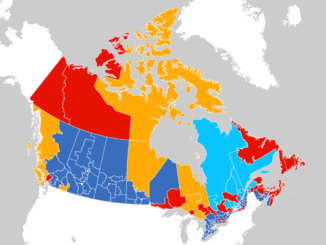
Interactive: How Canadians voted in the past 7 federal elections With the federal elections coming up on September 20th, Esri Canada has created an interactive map that highlights the last seven election results going back […]

No Picture
Education & Careers

Vancouver BCIT GIS Program seeking sponsors for student practicums/projects

5 September 2019 Karl Kliparchuk | BCIT

The BCIT GIS program is seeking sponsors, particularly companies and government agencies, to undertake a project or practicum with BCIT students in the January-May/June 2019/2020 semester. A BCIT GIS Practicum or Project offers a valuable opportunity […]

||||||||||||
Education & Careers

Canada’s Best and Brightest: Teams Announced for 2019 National Geomatics Competition in Calgary

14 February 2019 GoGeomatics Canada | BCIT

It’s that time of year once again: time for the National Geomatics Competition! The National Geomatics Competition (NGC) is Canada’s student-led geomatics competition. The NGC was created to increase the visibility of the geomatics profession, […]

Community

Our Biggest Events Ever Across Canada with 500 Participants & 20 Sponsors: 5th Annual 2018 GoGeomatics Canada Back to School Socials

5 October 2018 Jon Murphy | 2018

The 5th annual 2018 Back to School GoGeomatics socials were a huge hit with students and professionals. We hosted events from coast to coast: 15 GoGeomatics groups invited the Canadian geomatics community to celebrate the […]

||||||
Community

GoGeomatics Thanks our Gold & Silver Sponsors for our 15 Canada-wide 2018 Back to School GoGeomatics Socials

6 September 2018 GoGeomatics Canada | 2018

The GoGeomatics Meetups and Back to School Socials couldn’t be the events that they are without the help of our sponsors. When industry leaders step up to support our Canada-wide networking groups, they help us […]

BCIT GIS Student Posters
Education & Careers

Vancouver BCIT GIS Program seeking sponsors for student practicums/projects

31 August 2018 Karl Kliparchuk | BCIT

The BCIT GIS program is seeking sponsors, particularly companies and government agencies, to undertake a project or practicum with BCIT students in the January-May/June 2019/2020 semester. A BCIT GIS Practicum or Project offers a valuable opportunity […]

||||||
Education & Careers

Karl Kliparchuk talks top GIS Education at BCIT in Vancouver, BC, Canada

16 July 2018 Jon Murphy | BCIT

GoGeomatics kicks off our series of interview with geospatial program across the country on the West Coast of Canada.  We are highlighting some of the very best geomatics education programs in the world by talking […]

||BC Pinot Noir Map enlarged section|BC Pinot Noir Map
Technology

GIS in Action: How Does BC Pinot Noir Express Terroir?

8 March 2017 Karl Kliparchuk | 2012

Editors note: In this previously published article, Karl Kliparchuk, BCIT GIS Program Head & Instructor uses GIS to explore the aromas and flavors of wine from British Columbia, Canada. We are breaking down BC wine […]

Posts pagination

« 1 2 3 … 5 »

Events

Notice
There are no upcoming events.

View All Events

Services

  • Post a Job
  • Post an Ad
  • Post an Event
  • Post a Directory Listing
  • Post a Press Release
  • Media Kit
  • My Account
  • Login

Jobs

Post a Job
  • Canada Maps and Poster Gallery Volunteer Leads — GeoIgnite 2026
    remote
  • GIS & Data Analytics Lead
    Beaumont, AB
  • Lead Surveyor, Projects/Arpenteur-géomètre principal, projets; arpenteuse-géomètre principale, projets
    North Bay, Thunder Bay
  • Senior GIS Developer
    Calgary, AB
View All Jobs
  • Directories
    • Associations Directory
    • Industry Directory
    • Education Programs
    • Open Data
  • Volunteer
    • Start a GoGeomatics Group
    • Editors & Writers Group
  • About Us
    • GoGeomatics Media Kit
    • Who We Are
    • Contact Us
    • FAQ’s
    • Advertising
    • Marketing
  • Subscribe
GoGeomatics
GoGeomatics is the largest and most popular communications hub promoting the Canadian geospatial community. The business was incorporated in 2011. GoGeomatics hosts over 100 fun, free, location technology networking events each year in cities across Canada.

© 2025 GoGeomatics

  • facebook
  • Twitter
  • Linkedin
  • Youtube
  • Linkedin Group