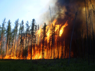
• facebook
  • Twitter
  • Linkedin
  • Youtube
  • Linkedin Group
  • Post a Job
  • Post an Ad
  • Post an Event
  • Post a Directory Listing
  • Post a Press Release
  • Media Kit
  • My Account
  • Login
GoGeomatics
  • MAGAZINE
    • BIM & GIS
    • Community
    • Conference news
    • Earth Observation
    • Education & Careers
    • GEOAI
    • Announcements
    • Reality Capture & Lidar
    • Science
    • Technology
  • Directories
    • ASSOCIATION
    • INDUSTRY
    • EDUCATION
    • Open Data
  • EVENTS
    • GeoIgnite Events
    • Events Calendar
    • GoGeomatics Meetups
  • Services
    • Advertising
    • Marketing
    • Post a Job
    • Post an Ad
    • Post an Event
    • Post a Press Release
    • Post a Directory Listing
    • Media Kit
    • Web Design
  • Find a Job
  • Volunteer
    • Start a GoGeomatics Group
    • Editors & Writers Group
  • About Us
    • About Us
    • Contact Us
    • Frequently Asked Questions
  • Videos
HomeClimate Change

Climate Change

CSA
Earth Observation

Turning Satellite Data into Impact: Five Canadian EO Projects Move to Next Phase

6 July 2025 GoGeomatics Canada | biodiversity

Satellite data is used in a wide range of fields, from climate change studies, maritime surveillance to the protection of ecosystems and biodiversity.In August 2023, through its Accelerating Earth Observation Innovations request for proposals, the Government of Canada invested […]

June 30 Digest
BIM & GIS

International Geospatial Digest June 30, 2025

30 June 2025 Volunteer Editors and Group Writers | AI

Saving Dying Reefs with Earth Engine and AI Bureaucratic Issues Facing a Joint European Space Conglomerate ESA Biomass Satellite returning long-awaited images NASA Sensor Identifying Polluted Run-off on California Coast Redrawing the Global Tea Map […]

Earth Observation

CanadaFireSat: The Future of Wildfire Resilience in Canada

26 June 2025 Alefiya Dungrawala | boreal communities

Year 2023 has witnessed the most devastating wildfire season that Canada has experienced in recent history. An unprecedented amount of damage has been inflicted on ecosystems and surrounding boreal communities, resulting in massive quantities of […]

Intl digest june 16
Community

International Geospatial Digest June 16, 2025

16 June 2025 Volunteer Editors and Group Writers | 3D Mapping

AI Foundation Models for Earth Observation: A New Chapter in Geospatial Intelligence FAO’s upgraded ABC-Map warns of a sharp decline in Crop Suitability by 2100 Real-Time GIS Dashboards Revolutionize Emergency Response  GlobalBuildingAtlas: First Complete Open […]

Earth Observation

After Landsat 7: Honouring a Legacy, Continuing the Mission

15 June 2025 Benedicta Antwi Boasiako | agriculture

Every pixel tells a story. On June 4, 2025, Landsat 7 was officially decommissioned, closing out a mission that spanned more than two decades. Launched in 1999, Landsat 7 carried the Enhanced Thematic Mapper Plus […]

Conference news

Satellite Earth Observation for Mapping and Assessing Terrestrial Water Dynamics

6 June 2025 Benedicta Antwi Boasiako | Canada

At GeoIgnite 2025, Dr. Shusen Wang, Senior Research Scientist at Natural Resources Canada’s Canada Centre for Mapping and Earth Observation (CCMEO), presented a comprehensive overview of using satellite Earth Observation (SEO) for monitoring Canada’s terrestrial […]

VS
Conference news

A Lifetime in Radar: Dr. Vernon Singhroy on Innovation, Influence, and Mentorship

6 June 2025 Benedicta Antwi Boasiako | AI

Dr. Vernon Singhroy is Canada’s one of the most distinguished Earth Observation scientists, known globally for his expertise in Synthetic Aperture Radar (SAR) and remote sensing applications. Over his decades-long career, he has published more […]

Conference news

How Space Can Help Canada in an Uncertain World

2 June 2025 Benedicta Antwi Boasiako | Brian Gallant

Space is no longer just about exploration — it’s about security, resilience, and economic sovereignty. In a powerful keynote at GeoIgnite 2025, Brian Gallant, CEO of Space Canada and former Premier of New Brunswick, made […]

Posts pagination

« 1 2 3 4 … 22 »

Events

Notice
There are no upcoming events.

View All Events

Services

  • Post a Job
  • Post an Ad
  • Post an Event
  • Post a Directory Listing
  • Post a Press Release
  • Media Kit
  • My Account
  • Login

Jobs

Post a Job
  • Software Engineer – Geographic Information System (GIS)
    Ottawa, ON
  • GIS Data Quality Analyst
    Burnaby, British Columbia
  • GIS Cartographer
    Montreal, QC
  • SENIOR PLANNER SPATIAL ANALYSIS SIPA
    Toronto, ON
View All Jobs
  • Directories
    • Associations Directory
    • Industry Directory
    • Education Programs
    • Open Data
  • Volunteer
    • Start a GoGeomatics Group
    • Editors & Writers Group
  • About Us
    • GoGeomatics Media Kit
    • Who We Are
    • Contact Us
    • FAQ’s
    • Advertising
    • Marketing
  • Subscribe
GoGeomatics
GoGeomatics is the largest and most popular communications hub promoting the Canadian geospatial community. The business was incorporated in 2011. GoGeomatics hosts over 100 fun, free, location technology networking events each year in cities across Canada.

© 2025 GoGeomatics

  • facebook
  • Twitter
  • Linkedin
  • Youtube
  • Linkedin Group