• facebook
  • Twitter
  • Linkedin
  • Youtube
  • Linkedin Group
  • Post a Job
  • Post an Ad
  • Post an Event
  • Post a Directory Listing
  • Post a Press Release
  • Media Kit
  • My Account
  • Login
GoGeomatics
  • MAGAZINE
    • BIM & GIS
    • Community
    • Conference news
    • Earth Observation
    • Education & Careers
    • GEOAI
    • Announcements
    • Reality Capture & Lidar
    • Science
    • Technology
    • Between the Poles
  • Directories
    • ASSOCIATION
    • INDUSTRY
    • EDUCATION
    • Open Data
  • EVENTS
    • GeoIgnite Events
    • Events Calendar
    • GoGeomatics Meetups
  • Services
    • Advertising
    • Marketing
    • Post a Job
    • Post an Ad
    • Post an Event
    • Post a Press Release
    • Post a Directory Listing
    • Media Kit
    • Web Design
  • Find a Job
  • Volunteer
    • Start a GoGeomatics Group
    • Editors & Writers Group
  • About Us
    • About Us
    • Contact Us
    • Frequently Asked Questions
  • Videos
HomeClimate Change

Climate Change

NASA fleet
Earth Observation

From Landsat to Letdown: Fifty Years of Space-Based Earth Observation Now at Risk

18 April 2025 Anusuya Datta | Climate Change

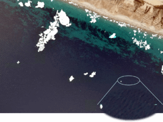
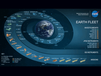
As the U.S. proposes deep cuts to NASA and NOAA, climate scientists warn of lasting damage to the global systems we rely on to track a changing planet. In 1972, the U.S. launched Landsat, the […]

|Beluga whales|Beluga Whales2|Beluga whales3
BIM & GIS

AI Meets Beluga Whales in the Arctic

17 April 2025 Anusuya Datta | AI in Conservation

Flying over Arctic waters, you’d never spot them. Beluga whales vanish against the ice below — their white bodies nearly invisible from above. Fisheries and Oceans Canada (DFO) has always watched these animals closely. For […]

|||
Earth Observation

Navigating the Dangers of Congested Orbital Space

14 April 2025 Alefiya Dungrawala | cascading impact

Is outer space too vast to be polluted? Will it eventually self-clean? Let us not forget that humans have a tendency to spread pollution. What we observe around us serves as the most profound silent […]

International-Digest-April-7||||||
Community

International Geospatial Digest for April 7, 2025

7 April 2025 Volunteer Editors and Group Writers | Arctic

Greenland Map Showing ‘Strategic Resources’ Eyed by USA, China Mapping the Destruction from the Myanmar Earthquake Apple Maps Adds More Than 250 Indigenous Placenames in Australia Stormy Rains in the Sahara Offer Clues to Past […]

National Glaciology Project|||||||Water Canada|Columbia Basin|Nrcan water model
Community

Securing Canada’s Water Resources in a Changing World

31 March 2025 David Legris | Canada

Water is crucial for all life on Earth, and as the planet increasingly feels the effects of climate change, freshwater is becoming an even more contentious issue. Canadians are fortunate to possess approximately 20% of […]

Arctic
Earth Observation

Canada Explores OTHR Horizons, New Partnerships to Maintain Arctic Sovereignty

31 March 2025 Anusuya Datta | Arctic Defense

Canada’s Arctic strategy just got a serious tech upgrade. A new $6-billion collaboration with Australia will develop an Over-the-Horizon Radar (OTHR) system. This cutting-edge technology is set to monitor Canada’s northern air and maritime approaches, […]

International-Digest-March-24|||
Community

International Geospatial Digest – March 24, 2025

24 March 2025 Volunteer Editors and Group Writers | AI

Mapping Mineral Resources at Opposite Poles Australia and Greenland have long been known for their abundance of valuable natural resources. However, with changing global geopolitics and increasing headlines surrounding the two, some maps that highlight […]

Floods|impact center|Canada climate change
Community

Improving Canada’s Civil Defence Can Strengthen Our Climate Resilience Too

24 March 2025 Nicholas Kellet | Canada

In Canada, we are going through the most consequential federal elections in generations. Although the campaign has just started, issues of economic and political sovereignty, and national security and defence spending might take precedence over […]

Posts pagination

« 1 … 4 5 6 … 23 »

Events

Notice
There are no upcoming events.

View All Events

Services

  • Post a Job
  • Post an Ad
  • Post an Event
  • Post a Directory Listing
  • Post a Press Release
  • Media Kit
  • My Account
  • Login

Jobs

Post a Job
  • Volunteer Editorial Contributor – Be Part of Canada’s Geomatics Story
    Remote
  • Junior Geomatics Field Technician – Technical Surveys
    Montréal, QC
  • GIS Specialist
    Amherst, Nova Scotia
  • Precast Structural BIM Specialist
    Calgary, Alberta
View All Jobs
  • Directories
    • Associations Directory
    • Industry Directory
    • Education Programs
    • Open Data
  • Volunteer
    • Start a GoGeomatics Group
    • Editors & Writers Group
  • About Us
    • GoGeomatics Media Kit
    • Who We Are
    • Contact Us
    • FAQ’s
    • Advertising
    • Marketing
  • Subscribe
GoGeomatics
GoGeomatics is the largest and most popular communications hub promoting the Canadian geospatial community. The business was incorporated in 2011. GoGeomatics hosts over 100 fun, free, location technology networking events each year in cities across Canada.

© 2026 GoGeomatics

  • facebook
  • Twitter
  • Linkedin
  • Youtube
  • Linkedin Group