cost

New Autonomous Airborne Mapping Solution Redefines Industry Expectations

Teledyne Optech is pleased to announce the latest addition to its innovative line of airborne laser terrain mappers, the Optech…

SNRC: UAV Integration Highly Valued in Canadian Marketplace

Due to a foreseeable increase in the demand for UAV acquired aerial imagery in resource management, various firms are already…

Paul Barker: What is Web GIS? Exploring the ‘new’ GIS

GIS has always been an integral part of forward thinking organizations. However, it has long struggled to break out of…

GIS Certification: AOLS Certificate of Registration

  Among the various types of GIS and Geomatics certifications available to Canadians, The Association of Ontario Land Surveyors (AOLS)…

Low-cost Feature-Rich RTK Receiver

SkyTraq Technology, a Taiwanese GNSS positioning technology company, introduces S2525F8-RTK, a low-cost, low-power, single frequency RTK receiver for applications requiring…

Find Your GIS & Geospatial Job: Career Seminar Ottawa April 9th

Finding a job in geospatial technology can be difficult. That’s why GoGeomatics Canada is bringing back our popular Career Seminar…

UAV Technology in the Canadian Forestry Sector

The Unmanned Aerial Vehicle (UAV) industry is soaring! Civilian drones are being applied in various global industries ranging from agriculture…

Esri Canada Named Gold Standard Winner among Canada’s Best Managed Companies

Esri Canada, the country’s leading enterprise geographic information system (GIS) solutions provider, has been named a Gold Standard winner among…

GIS Certification: ASPRS Certification

  One type of certification available for GIS and Geomatics professionals is the ASPRS Certification program available from the American…

Building Bridges: GeoAlliance

On March 15-16th the GeoAlliance is hosting a strategy event in Calgary you can see here.  They are trying to bring together members…

Location Encoding Systems – Could geographic coordinates be replaced and at what cost?

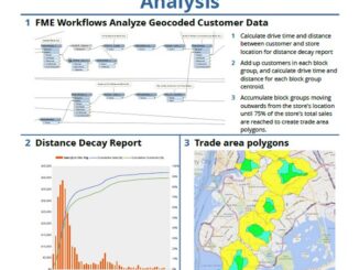
Geocoding is the process of converting a street address into a physical location that can be described with a pair…

Innovative solutions for bathymetry at Oceanology International 2016

March 7, 2016 — Teledyne Optech is pleased to announce that it is taking its most powerful and flexible surveying…