Technology
Canadian Geospatial Briefing May 25th, 2021: Mapping long-term impact of COVID-19 in BC Communities; Regina Youth-led Eco-friendly Transit Map; Map and Report Abandoned Rabbits; Visualizing Alberta Provincial Vaccine Data; Old-growth at Risk in BC; Anglers Drop Bait with Drones; Canadian to Send Dogecoin to the Moon; New OGC Board of Director
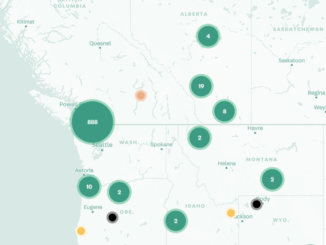
An unequal post-pandemic recovery: mapping the aftermath Mapping the COVID-19 pandemic’s secondary health impacts is co-led by SFU geography professors Valorie Crooks and Nadine Schuurman outlining how the COVID-19 pandemic’s long-term impacts will affect communities across […]