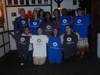
My COGS GIS Education, Part II
In my first article, I introduced the how and why I chose to attend COGS from the fall of 2014 to spring 2016. In Part 2, I wanted to give some insight into the first-year […]
The Canada Centre for Mapping and Earth Observation invites you to attend the Arctic Spatial Data Pilot Demonstration Webinar. Managed and organised by the Open Geospatial Consortium (OGC), the Pilot is sponsored by NRCan (Canada Centre […]
The Earth Observation (EO) Summit 2017 brings together in one exceptional event the 38th Canadian Symposium on Remote Sensing (CSRS), the 17th Congress of the Association Québécoise de Télédétection (AQT), the 11th Advanced SAR (ASAR) […]
These days drones are all the rage. Nevertheless, there are other ways to collect data from the sky! Blimps, balloons and kites are alternative was to collecting data or remote-sensing imagery. These are great unconventional solutions for […]
Let’s take a step back and have a look at what happened this year. To be honest, it was pretty hard selection. There are way too many things happening at this point around the world. […]
This is our list Canadian geomatics conferences and events for 2017. Here you will find events pertaining to GIS, remote sensing, surveying, cartography, and informatics. We’re always updating this list, so if you have a […]
Recently, I read an article about the Canadian Geospatial Data Infrastructure (CGDI) that seeks to explain why the CGDI, among many things, is relevant. While the Canada Centre for Mapping and Earth Observation (CCMEO) who is […]
Get your sleighbells jingling for the CRSS GoGeomatics Christmas Party! For the fourth year in a row, we’re teaming up with the Canadian Remote Sensing Society to throw a very special joint Holiday Social in […]