• facebook
  • Twitter
  • Linkedin
  • Youtube
  • Linkedin Group
  • Post a Job
  • Post an Ad
  • Post an Event
  • Post a Directory Listing
  • Post a Press Release
  • Media Kit
  • My Account
  • Login
GoGeomatics
  • MAGAZINE
    • BIM & GIS
    • Community
    • Conference news
    • Earth Observation
    • Education & Careers
    • GEOAI
    • Announcements
    • Reality Capture & Lidar
    • Science
    • Technology
    • Between the Poles
  • Directories
    • ASSOCIATION
    • INDUSTRY
    • EDUCATION
    • Open Data
  • EVENTS
    • GeoIgnite Events
    • Events Calendar
    • GoGeomatics Meetups
  • Services
    • Advertising
    • Marketing
    • Post a Job
    • Post an Ad
    • Post an Event
    • Post a Press Release
    • Post a Directory Listing
    • Media Kit
    • Web Design
  • Find a Job
  • Volunteer
    • Start a GoGeomatics Group
    • Editors & Writers Group
  • About Us
    • About Us
    • Contact Us
    • Frequently Asked Questions
  • Videos
HomeESA

ESA

||||
Technology

Geomatics: Discovering history in Canada’s Arctic waters

19 November 2015 Association of Ontario Land Surveyors | 2014

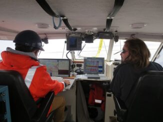
This article was reprinted with permission from the Ontario Professional Surveyor, Volume 56, No. 3, Summer 2015 By Theresa Nicholsi, Scott Youngblutii, Jonathan Mooreiii and Ryan Harrisiii. The 2014 discovery of HMS Erebus, one of […]

No Picture
Newsmakers & Press Releases

GPS Galileo taking flight: ten satellites now in orbit

16 September 2015 GoGeomatics Newsmakers | api

Europe’s own satellite navigation system has come a step nearer to completion, with Galileo 9 and 10 which lifted off together at 02:08 GMT on 11 September (04:08 CEST; 23:08 local time, 10 September) from Europe’s […]

|
Community

Canada Day Came Early at the Canada Aviation and Space Museum

7 July 2015 Robert Ryerson | 2014

June 23rd marked a special day in the history of aviation and space in Canada. A very special aircraft, a Convair-580, with its advanced Synthetic Aperture Radar (SAR) sensors, made its final flight after setting […]

|||
Technology

Findings Released from European Space Agency Earth Observation for Oil and Gas Project

26 May 2015 Andy Dean | 2014

Over the past 20 years, oil and gas companies have used satellite earth observation technology through the entire project lifecycle, from pre-acquisition, to full operations and decommissioning. In 2010, the European Space Agency (ESA) began […]

No Picture
Newsmakers & Press Releases

COM DEV secures access to key technology with strategic investment in Anokiwave

12 May 2015 GoGeomatics Newsmakers | 2015

CAMBRIDGE, ON, May 12, 2015 /CNW/ – COM DEV International Ltd. (TSX:CDV) today announced that it is making a US$500,000 investment in Anokiwave Inc., a radio frequency integrated circuit (RFIC) designer and supplier.  COM DEV is […]

No Picture
Newsmakers & Press Releases

PCI Geomatics Releases GXL 2015

5 March 2015 GoGeomatics Newsmakers | 2015

PCI Geomatics, a world leading developer of remote sensing and photogrammetric software and systems, announced today the release of its GeoImaging Accelerator (GXL) 2015 – the latest version of the company’s proven, high-performance, and scalable […]

No Picture
Newsmakers & Press Releases

Boeing Backs Canadian Satellite Design Challenge

22 January 2015 GoGeomatics Newsmakers | Australia

The Canadian Satellite Design Challenge Management Society (CSDCMS) is pleased to announce that it has received a $50,000 funding contribution from The Boeing Company for continued support of the Canadian Satellite Design Challenge (CSDC). The […]

No Picture
Newsmakers & Press Releases

Satellite-Based Earth Observation Market Analysis – Trends and Forecast

3 September 2014 GoGeomatics Newsmakers | 2020

Satellite-based Earth Observation (EO) is a process of using remote-sensing technique to gather information on the chemical, physical and biological aspects of the earth system. This technique allows the measurement of geophysical parameters of the […]

Posts pagination

« 1 … 3 4 5 6 »

Events

Notice
There are no upcoming events.

View All Events

Services

  • Post a Job
  • Post an Ad
  • Post an Event
  • Post a Directory Listing
  • Post a Press Release
  • Media Kit
  • My Account
  • Login

Jobs

Post a Job
  • Operations Spatial Data Assistant (Contract)
    Vaughan
  • GIS Analyst
    Saint John, New Brunswick
  • GIS Student Intern
    Elmsdale, Nova Scotia
  • Canada Impact+ Research Chair – Professor (Or Associate Professor)
    Lethbridge, Alberta
View All Jobs
  • Directories
    • Associations Directory
    • Industry Directory
    • Education Programs
    • Open Data
  • Volunteer
    • Start a GoGeomatics Group
    • Editors & Writers Group
  • About Us
    • GoGeomatics Media Kit
    • Who We Are
    • Contact Us
    • FAQ’s
    • Advertising
    • Marketing
  • Subscribe
GoGeomatics
GoGeomatics is the largest and most popular communications hub promoting the Canadian geospatial community. The business was incorporated in 2011. GoGeomatics hosts over 100 fun, free, location technology networking events each year in cities across Canada.

© 2026 GoGeomatics

  • facebook
  • Twitter
  • Linkedin
  • Youtube
  • Linkedin Group