• facebook
  • Twitter
  • Linkedin
  • Youtube
  • Linkedin Group
  • Post a Job
  • Post an Ad
  • Post an Event
  • Post a Directory Listing
  • Post a Press Release
  • Media Kit
  • My Account
  • Login
GoGeomatics
  • MAGAZINE
    • BIM & GIS
    • Community
    • Conference news
    • Earth Observation
    • Education & Careers
    • GEOAI
    • Announcements
    • Reality Capture & Lidar
    • Science
    • Technology
  • Directories
    • ASSOCIATION
    • INDUSTRY
    • EDUCATION
    • Open Data
  • EVENTS
    • GeoIgnite Events
    • Events Calendar
    • GoGeomatics Meetups
  • Services
    • Advertising
    • Marketing
    • Post a Job
    • Post an Ad
    • Post an Event
    • Post a Press Release
    • Post a Directory Listing
    • Media Kit
    • Web Design
  • Find a Job
  • Volunteer
    • Start a GoGeomatics Group
    • Editors & Writers Group
  • About Us
    • About Us
    • Contact Us
    • Frequently Asked Questions
  • Videos
Homegeomatics applications

geomatics applications

|||||
Technology

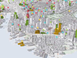
Covering New Ground with Digital Twins

13 June 2022 Jacob Pesaruk | 3D Mapping

Following the rapid advance and applications of geospatial technology has always been a fundamental aspect of the GoGeomatics community. As the study of earth systems has often relied on advancements in geospatial research, finding and […]

No Picture
Community

Top Ten Climate Change Maps and GIS Applications

7 March 2017 Priscilla Ancinelli | agriculture

Awareness for climate change has been steadily increasing ever since the Green Revolution in the 1960s. There is a plethora of data, maps, and Geographic Information Systems (GIS) applications available freely or accessible to the […]

|||
Technology

Operational Use of Remotely Piloted Aircraft System (RPAS) for Geomatics Applications

2 December 2016 Sabina Zaidi | 2017

Recently, I reviewed a report by the Canadian Council of Geomatics on the use of Remotely Piloted Aircraft Systems (RPAS) for geomatics applications here at home. It was based on a study led by NWT […]

|
Education & Careers

Geospatial Development: Enhancing GIS curricula with programming skills at UNB

29 November 2016 Emmanuel Stefanakis | 2014

Geospatial information science and technology (GIS&T) has rapidly evolved over the last few decades. This evolution has created a highly demanding job market for GIS professionals [3,4]. Recently, students, graduates, and professionals are more and […]

No Picture
Community

Location Encoding Systems – Could geographic coordinates be replaced and at what cost?

11 March 2016 Emmanuel Stefanakis | 2015

Geocoding is the process of converting a street address into a physical location that can be described with a pair of geographic coordinates. It is estimated that over 40% of the world population is physically […]

No Picture
Newsmakers & Press Releases

St-Isidore, Ontario: ING Robotic Aerial Mapping / Precision Agriculture

22 July 2014 GoGeomatics Newsmakers | 2012

ING Robotic Aviation is partnering with ASG Mapping to rigorously assess and develop the application of small robotic aircraft systems for gathering high quality, positionally accurate, and interoperable geospatial data. This project is focused on […]

No Picture
Community

Furthering Canada’s Geomatics Strategy: New Visions – New Direction – New Future

6 May 2013 Jeff_Thurston | 2012

The recent publication of the ‘Canadian Geomatics Community Strategy “White Paper” and Scenarios’ has added another perspective toward furthering the development of geomatics and the use of spatial data in Canada.  The “purpose is to provide […]

Community

Updated 2013 Canadian Geomatics Conferences & Events: GIS, Remote Sensing, Surveying

1 May 2013 GoGeomatics Canada | 2012

We decided to update our list of events and conferences that might be of interest to the geomatics community for 2013 so here it is. Conferences and geomatics events are good for your career health. […]

Posts pagination

1 2 »

Events

Notice
There are no upcoming events.

View All Events

Services

  • Post a Job
  • Post an Ad
  • Post an Event
  • Post a Directory Listing
  • Post a Press Release
  • Media Kit
  • My Account
  • Login

Jobs

Post a Job
  • Canada Maps and Poster Gallery Volunteer Leads — GeoIgnite 2026
    remote
  • GIS & Data Analytics Lead
    Beaumont, AB
  • Lead Surveyor, Projects/Arpenteur-géomètre principal, projets; arpenteuse-géomètre principale, projets
    North Bay, Thunder Bay
  • Senior GIS Developer
    Calgary, AB
View All Jobs
  • Directories
    • Associations Directory
    • Industry Directory
    • Education Programs
    • Open Data
  • Volunteer
    • Start a GoGeomatics Group
    • Editors & Writers Group
  • About Us
    • GoGeomatics Media Kit
    • Who We Are
    • Contact Us
    • FAQ’s
    • Advertising
    • Marketing
  • Subscribe
GoGeomatics
GoGeomatics is the largest and most popular communications hub promoting the Canadian geospatial community. The business was incorporated in 2011. GoGeomatics hosts over 100 fun, free, location technology networking events each year in cities across Canada.

© 2025 GoGeomatics

  • facebook
  • Twitter
  • Linkedin
  • Youtube
  • Linkedin Group