
Education & Careers
My COGS GIS Education, Part II
In my first article, I introduced the how and why I chose to attend COGS from the fall of 2014 to spring 2016. In Part 2, I wanted to give some insight into the first-year […]
In my first article, I introduced the how and why I chose to attend COGS from the fall of 2014 to spring 2016. In Part 2, I wanted to give some insight into the first-year […]
Editors note: This article has been jointly written by Nicolas Gignac, Dami Sonoiki (eHealth Africa) and Samuel Aiyeoribe (eHealth Africa). These authors would like to thank Yves Moisan, Vincent Mora (Oslandia) and Vincent Picavet (Oslandia) for their […]

This is the first of two articles on the release of ParcelMap BC Data, which we see as a significant event in the movement towards Open GIS Data in Canada. This month we’ll cover the […]
In today’s geomatics society, ArcGIS, developed by Esri, is a giant and dominates the GIS software market. However, there are some other great and powerful GIS software applications. QGIS is a typical GIS application among […]

Recently, I read an article about the Canadian Geospatial Data Infrastructure (CGDI) that seeks to explain why the CGDI, among many things, is relevant. While the Canada Centre for Mapping and Earth Observation (CCMEO) who is […]

Editors note: This article has been jointly written by Bruce McCormack and Gordon Plunkett. Bios can be found at the bottom of the article. Most people like to predict the future. People are interested in […]

After completing an undergraduate degree in 2015, (Geography and Environmental Studies at the University of Toronto) I needed to determine which direction to take in the next chapter of my academic and professional career. I […]
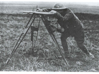
Whether its businesses, governments or for personal use, Geomatics offers everyday solutions to the worlds questions. The Canadian Armed Forces is no exception. These highly trained and dedicated Geo Techs are members of the Military […]