GML

The Open Geospatial Consortium (OGC): proposed GeoRSS Community Standard

The Open Geospatial Consortium (OGC®) is requesting public comment on the proposed GeoRSS Community Standard.  First available in 2006, GeoRSS…

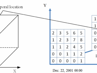
NetCDF: a growing standard for encoding georeferenced data in binary form

Recently, the Open Geospatial Consortium (OGC) has announced an extension to the OGC CF-netCDF 3.0 encoding standard that specifies how…

Elevation Web Services: Limitations and Prospects

Elevation Web Services: Limitations and Prospects Elevation data is necessary for a wide range of geospatial applications such as creating…

Standardizing IoT via the Open Geospatial Consortium Registry Platform

While IoT continues to grow in hype and in real importance, all of this excitement will start to wane if…

Future Prospects For 3D Geomatics In Canada

The future holds great promise for 3D when it comes to geomatics in Canadian education, industry and business. One might…

All the Geomatics Acronyms You Wanted to Know but were Too Afraid to Ask

Here in Canada, there are many geomatics acronyms that get tossed around. During the recent “Team Canada” event that the…

Geomatics to Geomantics

From my memory (which is, unfortunately, diming with each passing year) the word “geomatics”, defined as the automation of geography,…