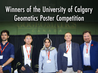
GNSS

Geomatics Leadership In Canada: Assessing The State and Challenges

When GoGeomatics Canada asked me to write on the topic of  “leadership in the geomatics community in Canada” I pondered…

GoGeomatics Awarded Contract: Maintenance of Canada’s Largest Enterprise GIS

‘Twas the week before Christmas and GoGeomatics has been called in to assist one of the largest non-profit clients in…

Canada’s Arctic: Spatial Info/Geotech Opportunity

Canada’s north has always been a challenge to those living there and to geoscience professionals alike. The sheer size of…

Brad Maguire: GIS Instructor at Vancouver Island University

GoGeomatics: Welcome to the GoGeomatics Canada community. First off, can you tell us about where you are from and where…

Inside TECTERRA’s Investing in Innovation Event!

Hello GIS, Geomatics, and Remote Sensing Friends! In February, I was given the opportunity to attend TECTERRA’s Investing in Innovation:…

Jean-François Dionne – Senior Geomatics Specialist at WESA Group Inc in Ottawa

The first GoGeomatics Canada interview for February is with Jean-François Dionne. He is the Senior Geomatics Specialist at WESA Group…

43 Degrees North – Surveying and Mapping Solutions

GoGeomatics is continuing the exploration of careers in surveying by interviewing Thomas Hoppe, the founder of 43 Degrees North – Surveying and Mapping Solutions. 43 Degrees North is situated in Cobourg Ontario in picturesque Northumberland County along the north shore of Lake Ontario is a professional Land Surveying and Geomatics company in Ontario Canada. They provide a variety of geo-referenced solutions from boundary surveys, aerial photography ground support, pre-engineering surveys, construction layout, and survey training with an emphasis on GPS applications and technology

Topcon Experienced Canadian Surveyor

We had the opportunity to talk with Mike Strutt about surveying and his career. Mike is one of the most experienced surveyors in Canada . began his survey career in 1974 and managed his first GPS project in 1987 while a field officer with the Geodetic Survey of Canada. Prior to joining Topcon where he now manages RTN Services, Support & Training, Mike spent in excess of 11 years and 10,000 hours delivering instruction on the use of GPS for surveying and mapping.

If you’re thinking about getting into surveying or just more about what a surveyor does this is a must read.

GPS_survey_marker

Survey Crew Chief / Geomatics Technician

We would like to introduce Wendy Innes, a graduate of Marine Geomatics program at COGS to help better explain and define what a Survey Crew Chief role could be.

Dan Eslinger of NavCom Technology Inc

Manager Software Engineering

Dan Eslinger of NavCom Technology Inc was kind enough to talk with GoGeomatics to help better explain and define what a Manager Software Engineering role could be.