• facebook
  • Twitter
  • Linkedin
  • Youtube
  • Linkedin Group
  • Post a Job
  • Post an Ad
  • Post an Event
  • Post a Directory Listing
  • Post a Press Release
  • Media Kit
  • My Account
  • Login
GoGeomatics
  • MAGAZINE
    • BIM & GIS
    • Community
    • Conference news
    • Earth Observation
    • Education & Careers
    • GEOAI
    • Announcements
    • Reality Capture & Lidar
    • Science
    • Technology
  • Directories
    • ASSOCIATION
    • INDUSTRY
    • EDUCATION
    • Open Data
  • EVENTS
    • GeoIgnite Events
    • Events Calendar
    • GoGeomatics Meetups
  • Services
    • Advertising
    • Marketing
    • Post a Job
    • Post an Ad
    • Post an Event
    • Post a Press Release
    • Post a Directory Listing
    • Media Kit
    • Web Design
  • Find a Job
  • Volunteer
    • Start a GoGeomatics Group
    • Editors & Writers Group
  • About Us
    • About Us
    • Contact Us
    • Frequently Asked Questions
  • Videos
Homehatfield consultants

hatfield consultants

|||
Technology

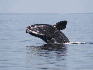
Geomatics Tools In The Protection and Conservation of North American Right Whales

24 February 2021 Nick O'Hanley | acoustic glider

Right Whale Biology + Conservation When speaking about declining populations in species, the words endangered, vulnerable and threatened often come to the forefront but for most people, those are vague and encompassing words that do […]

|||
Technology

GEOAnalytics.ca – A demonstration cloud-native open platform for Big Data geoscience

27 July 2020 Andy Dean | api

Current data-driven and computing intensive research on climate-change, ecosystem modeling, and environmental and natural resources monitoring is based on the collection, management, analysis, and dissemination of geospatial data. Currently, the acquisition and analysis of satellite […]

|
Newsmakers & Press Releases

User Needs Assessment for the Canadian Geospatial Data Infrastructure published by Natural Resources Canada

24 July 2019 Andy Dean | CGDI

User Needs Assessment for the Canadian Geospatial Data Infrastructure published by Natural Resources Canada – HATFIELD CONSULTANTS PARTNERSHIP Hatfield led in partnership with Natural Resources Canada, released outputs from a cross-Canada User Needs Assessment (UNA) […]

||||
Technology

Hatfield releases R-BAM algorithm to all Canadian wildfire agencies

21 March 2019 Andy Dean | algorithm

The Rapid Burned Area Mapping (R-BAM) technology was developed over the last three years by Hatfield Consultants and aims to complement conventional wildfire observation and assessment techniques by providing frequent updates on wildfire burn areas […]

Events

Notice
There are no upcoming events.

View All Events

Services

  • Post a Job
  • Post an Ad
  • Post an Event
  • Post a Directory Listing
  • Post a Press Release
  • Media Kit
  • My Account
  • Login

Jobs

Post a Job
  • Canada Maps and Poster Gallery Volunteer Leads — GeoIgnite 2026
    remote
  • GIS & Data Analytics Lead
    Beaumont, AB
  • Lead Surveyor, Projects/Arpenteur-géomètre principal, projets; arpenteuse-géomètre principale, projets
    North Bay, Thunder Bay
  • Senior GIS Developer
    Calgary, AB
View All Jobs
  • Directories
    • Associations Directory
    • Industry Directory
    • Education Programs
    • Open Data
  • Volunteer
    • Start a GoGeomatics Group
    • Editors & Writers Group
  • About Us
    • GoGeomatics Media Kit
    • Who We Are
    • Contact Us
    • FAQ’s
    • Advertising
    • Marketing
  • Subscribe
GoGeomatics
GoGeomatics is the largest and most popular communications hub promoting the Canadian geospatial community. The business was incorporated in 2011. GoGeomatics hosts over 100 fun, free, location technology networking events each year in cities across Canada.

© 2025 GoGeomatics

  • facebook
  • Twitter
  • Linkedin
  • Youtube
  • Linkedin Group