high-resolution

International Geospatial Digest December 18th, 2023

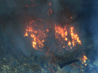
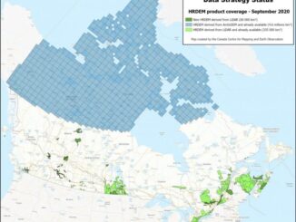
Automatic digitizing of imagery using QGIS GISCorps volunteer assisting Oracabessa Marine Trust Interactive map shows the locations of over 300…

CANADA’S NATIONAL ELEVATION DATA STRATEGY UPDATE NOVEMBER 2022

Fall 2022 LIDAR ACQUISITIONS 2022 IN SUPPORT OF THE FLOOD HAZARD IDENTIFICATION AND MAPPING PROGRAM (FHIMP) Flood hazard maps are…

Maxar’s Global Technology Shift from 2D to 3D

Maxar Endeavours to use Space and Earth Intelligence for the future of Geospatial Intelligence “Imagery is the foundation of our…

CANADA’S NATIONAL ELEVATION DATA STRATEGY UPDATE

Fall 2021 LIDAR ACQUISITIONS 2021 The 2021 LiDAR acquisition period is already coming to an end. In addition to integrating…

GeoIgnite 2020 Video: Maxar- Monitoring Arctic Expansion and the Impact of Climate Change with High-Resolution Imager

GeoIgnite is Canada’s national geospatial conference hosted by GoGeomatics Canada. GeoIgnite was held online via Zoom from July 22nd to…

NATIONAL ELEVATION DATA STRATEGY UPDATE

July 2020 STATUS OF THE LIDAR ACQUISITIONS The National Elevation Data Strategy team of the Canadian Centre for Mapping and…

CANADA’S NATIONAL ELEVATION DATA STRATEGY UPDATE

November 2019 HRDEM FOR THE ENTIRE CANADIAN ARCTIC! In August, Natural Resources Canada (NRCan) made available a new release of the High…