Technology
Anything New in the World of Mapping APIs?
Last week was a big week in the web and mobile mapping world on at least two fronts. First, Amazon announced plans to release a mapping API to support the Kindle Fire HD. That alone […]
Last week was a big week in the web and mobile mapping world on at least two fronts. First, Amazon announced plans to release a mapping API to support the Kindle Fire HD. That alone […]
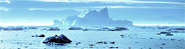
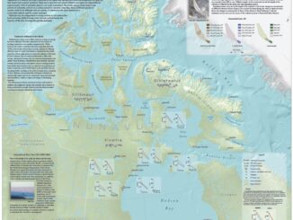
Canada’s north has always been a challenge to those living there and to geoscience professionals alike. The sheer size of the arctic and extreme cold have resulted in difficult access and contributed toward significant challenges […]
GoGeomatics Canada is talking to Lawrie Keillor-Faulkner a member of the GIS Faculty at Fleming College in Ontario. GoGeomatics: Welcome to the GoGeomatics Canada community. To get started can you tell us about where you […]
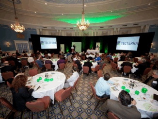
Hello GIS, Geomatics, and Remote Sensing Friends! In February, I was given the opportunity to attend TECTERRA’s Investing in Innovation: Geomatics Growth & New Opportunities for Canadian Companies event held in Ottawa, Ontario. After graduating […]

This time around GoGeomatics Canada is looking to the west to find Hydrologist Timothy Ensom at Golder Associates. Welcome to GoGeomatics Canada Tim. Thanks for taking the time to talk to us. GoGeomatics: First off […]

Since our Top 10 Canadian Geomatics Twitter feeds article was such a (controversial) hit, we’ve decided to do another entry in our social media series. This time we’re taking a look at the hottest Canadian […]

Amy Barker has been working for the Government of the Northwest Territories for over 2 years as a G.I.S. Officer. Amy enjoys working with data pertaining to culture and heritage and is currently working in […]

Welcome Catherine Ennis to the GoGeomatics community! GoGeomatics: We would like to give our readers some background. Let’s start with some basic career history. Could you tell us where you are from and what lead […]