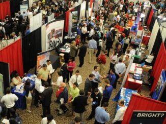
• facebook
  • Twitter
  • Linkedin
  • Youtube
  • Linkedin Group
  • Post a Job
  • Post an Ad
  • Post an Event
  • Post a Directory Listing
  • Post a Press Release
  • Media Kit
  • My Account
  • Login
GoGeomatics
  • MAGAZINE
    • BIM & GIS
    • Community
    • Conference news
    • Earth Observation
    • Education & Careers
    • GEOAI
    • Announcements
    • Reality Capture & Lidar
    • Science
    • Technology
  • Directories
    • ASSOCIATION
    • INDUSTRY
    • EDUCATION
    • Open Data
  • EVENTS
    • GeoIgnite Events
    • Events Calendar
    • GoGeomatics Meetups
  • Services
    • Advertising
    • Marketing
    • Post a Job
    • Post an Ad
    • Post an Event
    • Post a Press Release
    • Post a Directory Listing
    • Media Kit
    • Web Design
  • Find a Job
  • Volunteer
    • Start a GoGeomatics Group
    • Editors & Writers Group
  • About Us
    • About Us
    • Contact Us
    • Frequently Asked Questions
  • Videos
Homeland

land

Career Fair
Education & Careers

York Geomatics Career Fair January 31st

8 January 2014 GoGeomatics Canada | AOLS

The York Geomatics student club is holding a career fair for the geomatics industry January 31st.  If you are looking for a job in the geomatics sector, this will be a prime opportunity to get […]

No Picture
Community

January 1, 2014 Canadian GoGeomatics MERX Report

6 January 2014 GoGeomatics Canada | 2013

Here is the January 1st, 2014 GoGeomatics MERX Report. Login to see the contracts on MERX Geomatics Services Published:                          19/12/2013 Closing:       […]

No Picture
Community

Surveying in Action – Occam’s razor at Gull River Indian Reserve: The south boundary

19 December 2013 Association of Ontario Land Surveyors | 2013

By Dr. Brian Ballantyne Surveyor General Branch, NRCan Reprinted from the Ontario Professional Surveyor, Volume 56, No. 4, Fall 2013 Abstract – The south boundary of the Gull River Indian Reserve is a straight line […]

No Picture
Community

The Top Canadian Geomatics Stories of November 2013

4 December 2013 GoGeomatics Canada | 2013

Before we close on the final month of 2013, let’s take a moment to look back on this month’s developments in Canadian geomatics news.  These are the top Canadian geomatics stories of November 2013.  Please […]

VGI Data|The Geo-Wiki Project
Community

VGI: the Wild West of Data and GIS

18 November 2013 Matthew Boyter | 2012

In recent years, high–resolution spaceborne imagery (HRSI), up to 50cm spatial resolution, has become readily available for no cost using such applications as Google Earth and Bing Maps. Thanks to this new availability of free […]

No Picture
Community

The Economics of Using the Term Geomatics

11 November 2013 Greg Duffy | application

I am very pleased for our industry that the discussions, led by GoGeomatics, surrounding the term Geomatics has been enthusiastic and roundly presented. For reasons I cannot quickly explain, my mind goes to the basics […]

Lidar / GPS Terrain Modelling for Ice Jam Emergency Response|Lidar / GPS Terrain Modelling for Ice Jam Emergency Response
Community

Prince George BC: Lidar / GPS Terrain Modelling for Ice Jam Emergency Response

7 November 2013 McElhanney | Acquisition

Unprecedented ice jams led to extensive flooding in Prince George as temperatures dipped to record lows in the winter of 2007/2008. City officials declared a state of local emergency on December 11, 2007, ordering dozens […]

No Picture
Community

More Than Just a Name: What The Geomatics Industry Needs to Reach The Public

4 November 2013 Jeff_Thurston | aerial

There has been much written about ‘geo’ terms, and the awareness of them,  in Canada recently.  Jonathan Murphy of GoGeomatics recently summed up many of the age old debates, issues and perceptions in his article […]

Posts pagination

« 1 … 33 34 35 … 48 »

Events

Notice
There are no upcoming events.

View All Events

Services

  • Post a Job
  • Post an Ad
  • Post an Event
  • Post a Directory Listing
  • Post a Press Release
  • Media Kit
  • My Account
  • Login

Jobs

Post a Job
  • Canada Maps and Poster Gallery Volunteer Leads — GeoIgnite 2026
    remote
  • GIS & Data Analytics Lead
    Beaumont, AB
  • Lead Surveyor, Projects/Arpenteur-géomètre principal, projets; arpenteuse-géomètre principale, projets
    North Bay, Thunder Bay
  • Senior GIS Developer
    Calgary, AB
View All Jobs
  • Directories
    • Associations Directory
    • Industry Directory
    • Education Programs
    • Open Data
  • Volunteer
    • Start a GoGeomatics Group
    • Editors & Writers Group
  • About Us
    • GoGeomatics Media Kit
    • Who We Are
    • Contact Us
    • FAQ’s
    • Advertising
    • Marketing
  • Subscribe
GoGeomatics
GoGeomatics is the largest and most popular communications hub promoting the Canadian geospatial community. The business was incorporated in 2011. GoGeomatics hosts over 100 fun, free, location technology networking events each year in cities across Canada.

© 2025 GoGeomatics

  • facebook
  • Twitter
  • Linkedin
  • Youtube
  • Linkedin Group