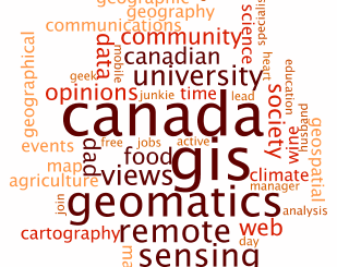
• facebook
  • Twitter
  • Linkedin
  • Youtube
  • Linkedin Group
  • Post a Job
  • Post an Ad
  • Post an Event
  • Post a Directory Listing
  • Post a Press Release
  • Media Kit
  • My Account
  • Login
GoGeomatics
  • MAGAZINE
    • BIM & GIS
    • Community
    • Conference news
    • Earth Observation
    • Education & Careers
    • GEOAI
    • Announcements
    • Reality Capture & Lidar
    • Science
    • Technology
  • Directories
    • ASSOCIATION
    • INDUSTRY
    • EDUCATION
    • Open Data
  • EVENTS
    • GeoIgnite Events
    • Events Calendar
    • GoGeomatics Meetups
  • Services
    • Advertising
    • Marketing
    • Post a Job
    • Post an Ad
    • Post an Event
    • Post a Press Release
    • Post a Directory Listing
    • Media Kit
    • Web Design
  • Find a Job
  • Volunteer
    • Start a GoGeomatics Group
    • Editors & Writers Group
  • About Us
    • About Us
    • Contact Us
    • Frequently Asked Questions
  • Videos
Homelaw

law

|||Weighted Raster Calculation|Raw results
Community

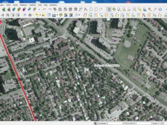
Vineyard Site Suitability Using Multi-criteria Evaluation

5 November 2012 Darren | accuracy

“Wine is light held together by water” – Galileo Preamble…. Beginning in my third year at Brock, I found myself becoming intensely interested in wine and viticulture, so much so that I began revolving my […]

|||||||||||||||||||||||||||||||||||
Technology

Anything New in the World of Mapping APIs?

1 October 2012 Dennis Nazarenko | api

Last week was a big week in the web and mobile mapping world on at least two fronts. First, Amazon announced plans to release a mapping API to support the Kindle Fire HD. That alone […]

Technology

The Ottawa Tree Canopy Cover Mapping Project

28 September 2012 Regie | 2012

The City of Ottawa Official Plan set a target of 30% tree canopy cover for the entire city. To the author’s knowledge there is no information on the amount of tree canopy for the entire […]

Community

The Best GIS Education in Canada

25 September 2012 GoGeomatics Canada | 2012

In 1960 Canada brought the first GIS to use.  We can thank Dr. Roger Tomlinson for this genesis. He called the first true GIS, The Canada Geographic Information System.  GIS is now an indispensable tool the […]

No Picture
Education & Careers

Dave MacLean: GIS Faculty, COGS Advanced Diploma in Geographic Sciences

24 September 2012 David | 2012

GoGeomatics Canada is talking to Dave MacLean – a member of the GIS Faculty at the Centre of Geographic Sciences (COGS) in Lawrencetown, Nova Scotia. GoGeomatics: Welcome to the GoGeomatics Canada community. To get started, […]

|
Education & Careers

Lawrie Keillor-Faulkner: GIS Instructor, Fleming College

20 September 2012 Lawrie | 2012

GoGeomatics Canada is talking to Lawrie Keillor-Faulkner a member of the GIS Faculty at Fleming College in Ontario. GoGeomatics: Welcome to the GoGeomatics Canada community. To get started can you tell us about where you […]

No Picture
Community

Dr. Robert ‘Bob’ Ryerson: A Canadian Geomatics Perspective on our Industry and Future

10 January 2012 Melanie | 2013

GoGeomatics has had the pleasure of speaking with Dr. Robert ‘Bob’ Ryerson of KIM Geomatics Corporation.   Along with his recently published book titled “Why ‘Where’ Matters“, Dr. Ryerson is Canada’s first PhD in Remote […]

Posts pagination

« 1 … 10 11

Events

Notice
There are no upcoming events.

View All Events

Services

  • Post a Job
  • Post an Ad
  • Post an Event
  • Post a Directory Listing
  • Post a Press Release
  • Media Kit
  • My Account
  • Login

Jobs

Post a Job
  • Canada Maps and Poster Gallery Volunteer Leads — GeoIgnite 2026
    remote
  • GIS & Data Analytics Lead
    Beaumont, AB
  • Lead Surveyor, Projects/Arpenteur-géomètre principal, projets; arpenteuse-géomètre principale, projets
    North Bay, Thunder Bay
  • Senior GIS Developer
    Calgary, AB
View All Jobs
  • Directories
    • Associations Directory
    • Industry Directory
    • Education Programs
    • Open Data
  • Volunteer
    • Start a GoGeomatics Group
    • Editors & Writers Group
  • About Us
    • GoGeomatics Media Kit
    • Who We Are
    • Contact Us
    • FAQ’s
    • Advertising
    • Marketing
  • Subscribe
GoGeomatics
GoGeomatics is the largest and most popular communications hub promoting the Canadian geospatial community. The business was incorporated in 2011. GoGeomatics hosts over 100 fun, free, location technology networking events each year in cities across Canada.

© 2025 GoGeomatics

  • facebook
  • Twitter
  • Linkedin
  • Youtube
  • Linkedin Group