• facebook
  • Twitter
  • Linkedin
  • Youtube
  • Linkedin Group
  • Post a Job
  • Post an Ad
  • Post an Event
  • Post a Directory Listing
  • Post a Press Release
  • Media Kit
  • My Account
  • Login
GoGeomatics
  • MAGAZINE
    • BIM & GIS
    • Community
    • Conference news
    • Earth Observation
    • Education & Careers
    • GEOAI
    • Announcements
    • Reality Capture & Lidar
    • Science
    • Technology
    • Between the Poles
  • Directories
    • ASSOCIATION
    • INDUSTRY
    • EDUCATION
    • Open Data
  • EVENTS
    • GeoIgnite Events
    • Events Calendar
    • GoGeomatics Meetups
  • Services
    • Advertising
    • Marketing
    • Post a Job
    • Post an Ad
    • Post an Event
    • Post a Press Release
    • Post a Directory Listing
    • Media Kit
    • Web Design
  • Find a Job
  • Volunteer
    • Start a GoGeomatics Group
    • Editors & Writers Group
  • About Us
    • About Us
    • Contact Us
    • Frequently Asked Questions
  • Videos
Homelidar

lidar

||
Technology

Your Global Geospatial Briefing for May 14th: Geospatial Foundations at GeoIgnite; GeoAI history; WorldView-4; Falcon 9; Elon Musk on LiDAR

13 May 2019 GoGeomatics Canada | AI

Leverage tech for the public at GeoIgnite A new article on GeoIgnite 2019 in the Ottawa Business Journal highlights the “Geospatial Foundations” aspect that provided the framework for how the whole conference came together—that is, […]

|||||
Technology

Your Canadian Geospatial Briefing for May 6th: Nadine Alameh at GeoIgnite; Drone Delivery Canada; Inuvik Satellite Station; New Brunswick LiDAR data

6 May 2019 GoGeomatics Canada | Canadian conferences

GeoIgnite features plenary speaker from the OGC  GeoIgnite is packing its schedule with plenary speakers who also happen to be leaders in the international geospatial community. Nadine Alameh of the Open Geospatial Consortium has recently […]

|
Newsmakers & Press Releases

New Brunswick: 1st Canadian Province to Complete Lidar Coverage with an Open Data License*

14 April 2019 GoGeomatics Newsmakers | aerial imagery

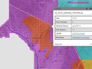
Re-posted from Bernie Connors Monday, April 8, 2019, New Brunswick releases the 2018 lidar data for public download and becomes the first Canadian province to achieve complete aerial lidar coverage under an open data license. […]

||
Technology

Your Global Geospatial Briefing for April 8th: 5G; 3D at Depth; Geospatial Intelligence Centre; Vulcan subscribes to Maxar; Smart Cities, Smart Infrastructure

8 April 2019 GoGeomatics Canada | Geospatial Intelligence

AT&T prepares for 5G 5G is part of an oncoming data storm. 5G will be connected to autonomous cars, robotic factories, and seamless AR/VR, and it will require a faster, more efficient network. To that […]

LiDAR workstation|Studying Lab at UNB
Education & Careers

LiDAR Workshop held at UNB

18 February 2019 Murrium Zaheer | lidar

On the morning of the 25th of January, I headed down to the Forestry complex at the University of New Brunswick(UNB) to attend a LiDAR workshop that I had been looking forward to all week. […]

||
Community

A Look at #COGS Conference in Nova Scotia: Sensors High and Low

25 January 2019 Robert Maher | 3D Mapping

The Nova Scotia Community College (NSCC) hosted its third annual Winter conference at the Centre of Geographic Sciences (COGS) in Lawrencetown this week, January 23-24th.  There were twenty presentations (see link to program and abstracts). […]

||||
Technology

Canada’s National Elevation Data Strategy Updates from NRCan

24 January 2019 David Belanger | acquisitions

New Data Generated from LiDAR! Natural Resources Canada (NRCan) is proud to announce a new release of the product High Resolution Digital Elevation Model (HRDEM). This new and highly accurate data covers approximately 50,000 km2 […]

|||
Community

An Invitation to Younger (and Older) Geospatial Professionals

17 January 2019 Gene | Geomatics Networking

A core group of Younger Geospatial Professionals (YGPs) would like to take this opportunity to invite you, regardless of your age, to join (see below) this early start-up organization. As we all know, the geospatial […]

Posts pagination

« 1 … 23 24 25 … 37 »

Events

Notice
There are no upcoming events.

View All Events

Services

  • Post a Job
  • Post an Ad
  • Post an Event
  • Post a Directory Listing
  • Post a Press Release
  • Media Kit
  • My Account
  • Login

Jobs

Post a Job
  • GIS Technologist II
    Fernie, B.C.
  • GIS I TECHNOLOGIST
    Fernie, B.C.
  • Operations Spatial Data Assistant (Contract)
    Vaughan
  • GIS Analyst
    Saint John, New Brunswick
View All Jobs
  • Directories
    • Associations Directory
    • Industry Directory
    • Education Programs
    • Open Data
  • Volunteer
    • Start a GoGeomatics Group
    • Editors & Writers Group
  • About Us
    • GoGeomatics Media Kit
    • Who We Are
    • Contact Us
    • FAQ’s
    • Advertising
    • Marketing
  • Subscribe
GoGeomatics
GoGeomatics is the largest and most popular communications hub promoting the Canadian geospatial community. The business was incorporated in 2011. GoGeomatics hosts over 100 fun, free, location technology networking events each year in cities across Canada.

© 2026 GoGeomatics

  • facebook
  • Twitter
  • Linkedin
  • Youtube
  • Linkedin Group