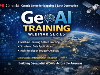
• facebook
  • Twitter
  • Linkedin
  • Youtube
  • Linkedin Group
  • Post a Job
  • Post an Ad
  • Post an Event
  • Post a Directory Listing
  • Post a Press Release
  • Media Kit
  • My Account
  • Login
GoGeomatics
  • MAGAZINE
    • BIM & GIS
    • Community
    • Conference news
    • Earth Observation
    • Education & Careers
    • GEOAI
    • Announcements
    • Reality Capture & Lidar
    • Science
    • Technology
  • Directories
    • ASSOCIATION
    • INDUSTRY
    • EDUCATION
    • Open Data
  • EVENTS
    • GeoIgnite Events
    • Events Calendar
    • GoGeomatics Meetups
  • Services
    • Advertising
    • Marketing
    • Post a Job
    • Post an Ad
    • Post an Event
    • Post a Press Release
    • Post a Directory Listing
    • Media Kit
    • Web Design
  • Find a Job
  • Volunteer
    • Start a GoGeomatics Group
    • Editors & Writers Group
  • About Us
    • About Us
    • Contact Us
    • Frequently Asked Questions
  • Videos
HomeMachine Learning

Machine Learning

BIM & GIS

International Geospatial Digest Nov 17, 2025

17 November 2025 Volunteer Editors and Group Writers | 3D Mapping System

Misinterpreted Google Earth Image Sparks Viral Claims Amid Sudan Conflict Mapping Britain on Foot: One Man’s 1,600-Mile Quest for Google MIT Develops Rapid 3D Mapping System for Search-and-Rescue Robots GIS Adoption Accelerates as Japan Strengthens […]

Community

Canadian Space Agency Launches 5 Million Dollar Satellite Biodiversity Initiative

3 October 2025 Kirstyn Howieson | AI

The Canadian Space Agency (CSA) has chosen 20 projects for funding totaling $5 million as part of its Satellite Mobilization for Biodiversity Action initiative. The program, which was first announced at the beginning of 2025, […]

GeoSessions
BIM & GIS

Geo Sessions 2025: NV5 Geospatial Unveils the Future of Intelligence Beyond the Map 

20 August 2025 Sven Cowan | agriculture

Geo Sessions has become one of the premier online events for professionals pushing the boundaries of geospatial technology. In 2024, more than 5,300 registrants from 159 countries came together to learn, share, and explore real-world […]

Intl digest june 16
Community

International Geospatial Digest June 16, 2025

16 June 2025 Volunteer Editors and Group Writers | 3D Mapping

AI Foundation Models for Earth Observation: A New Chapter in Geospatial Intelligence FAO’s upgraded ABC-Map warns of a sharp decline in Crop Suitability by 2100 Real-Time GIS Dashboards Revolutionize Emergency Response  GlobalBuildingAtlas: First Complete Open […]

GEOAI

GeoAI in Marine Monitoring: Can this Synergy Work?

28 May 2025 Alefiya Dungrawala | bathymetric surface

GeoAI is to use artificial intelligence (AI) in conjunction with geospatial data to address geographically oriented problems. The combination of GeoAI and marine is not as widespread as in other sectors. Though promising for environmental […]

Bryn Fosburg
Other

Beyond Boundaries: WGIC Horizons 2025 Explores the Future of Geospatial Innovation

29 April 2025 GoGeomatics Canada | AEC

The World Geospatial Industry Council (WGIC) kicked off its annual Horizons 2025 event in Denver with a powerful lineup of thought leaders, industry experts, and innovators all focused on the evolution of geospatial technologies and […]

BIM & GIS

Lidar Innovations and Trends to Look Out For in 2025

20 January 2025 Anusuya Datta | autonomous vehicles

The Lidar (Light Detection and Ranging) market has been experiencing rapid growth, with significant advancements in technology and an expanding range of applications. According to market reports, the global Lidar market size was valued at […]

BIM & GIS

Geospatial Industry Trends and Developments that Defined 2024

16 December 2024 Anusuya Datta | 3D modeling

The geospatial industry continued to evolve rapidly in 2024, driven by technological advancements and the increasing need for accurate and efficient spatial data. From artificial intelligence (AI) to innovations in reality capture solutions and satellite […]

Posts pagination

1 2 … 6 »

Events

Notice
There are no upcoming events.

View All Events

Services

  • Post a Job
  • Post an Ad
  • Post an Event
  • Post a Directory Listing
  • Post a Press Release
  • Media Kit
  • My Account
  • Login

Jobs

Post a Job
  • Canada Maps and Poster Gallery Volunteer Leads — GeoIgnite 2026
    remote
  • GIS & Data Analytics Lead
    Beaumont, AB
  • Lead Surveyor, Projects/Arpenteur-géomètre principal, projets; arpenteuse-géomètre principale, projets
    North Bay, Thunder Bay
  • Senior GIS Developer
    Calgary, AB
View All Jobs
  • Directories
    • Associations Directory
    • Industry Directory
    • Education Programs
    • Open Data
  • Volunteer
    • Start a GoGeomatics Group
    • Editors & Writers Group
  • About Us
    • GoGeomatics Media Kit
    • Who We Are
    • Contact Us
    • FAQ’s
    • Advertising
    • Marketing
  • Subscribe
GoGeomatics
GoGeomatics is the largest and most popular communications hub promoting the Canadian geospatial community. The business was incorporated in 2011. GoGeomatics hosts over 100 fun, free, location technology networking events each year in cities across Canada.

© 2025 GoGeomatics

  • facebook
  • Twitter
  • Linkedin
  • Youtube
  • Linkedin Group