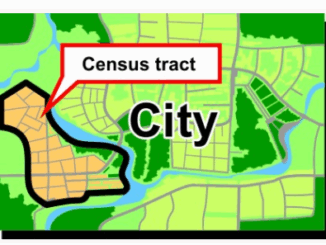
Live Map with Updates Coronavirus (COVID-19) situation
You can find the latest facts and figures using this ArcGIS live update map below for the coronavirus. Here are a few links that might be helpful if you are looking for information from the […]
The 6th annual GoGeomatics 2019 Back to School Socials have been a tremendous success. After coming off the success of GeoIgnite 2019 National Conference in Ottawa. Our groups and group leaders across the country came […]
Geospatial tech makes human life easier During the national conference at the Punjab Remote Sensing Centre on Big Geospatial Data and Analytics, Modelling and Application (BiGMAP), many specialists took the time to discuss the influence […]
OTTAWA, Ont., August 22, 2019 – Today, Sustainable Development Technology Canada (SDTC) , announces a funding partnership with, Ecopia Tech Corporation (Ecopia), to create the first comprehensive digital map of all of Sub-Saharan Africa. This […]
Many places throughout our country are named to remember the actions of Canadians in the defence of freedom and democracy. This interactive map shows how we remember them – eternally tying them to the lands, […]
Jonathan Murphy: Hi Claus, and welcome to the GoGeomatics Canada community. First off, can you tell us about where you are from and where you got your GIS education? Claus Rinner: Hi Jon, thanks for […]
Land surveying is an exciting Geomatics Career Field that is in high demand and often over looked by many young people when choosing a career path. Land surveyors are involved in many aspects of geomatics including urban and […]
Bert de Bruijn is an Ottawa IT security consultant and founder of the WikiWar Project. Bert is passionate about Crowdsourcing and Geovisualizing War History. A former member of the Canadian armed forces he’s been a […]