
Geographic data are applied in any location-based projects. We all might hear a lot about geographic terms but when we want to work directly with them, we should know the detailed definition of them. For instance, what is Census Tracts (CT)? How are their boundaries created? What are the names and codes for CTs about? Sometimes there is a lot of information that might overwhelm you. A couple of weeks ago I started researching geographic terms definitions and census geography examples on the Statistics Canada website. I put all my findings together in this article.
For the most updated information about geographic terms in Canada, you should go to Statistics Canada website > Census program > Geography, under Reference documents, select Illustrated Glossary
Standard Geographical Classification (SGC) 2016
The geographic areas’ official classification of Statistics Canada is called The Standard Geographical Classification (SGC).
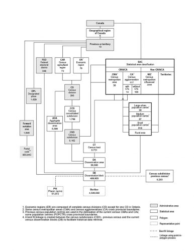
SGC provides names and codes for three hierarchically-related geographic areas: provinces and territories (PT), census divisions (CD) and census subdivisions (CSD). The unique codes for census metropolitan areas (CMA) and census agglomerations (CA) are represented as the variants of SGC 2016.
SGC delivers a range of geographic units that are convenient for gathering and compiling data, and beneficial for spatial analysis of economic and social statistics.
Read more here.
This figure shows a graphical representation of the hierarchical relationship between the standard geographical areas used for the dissemination of the 2016 Census of Canada. Source: Figure 1.1 Hierarchy of standard geographic areas for dissemination, 2016 Census
Census division (CD)
Census division (CD) is the general term for provincially legislated areas (such as county, municipalité régionale de comté and regional district) or their equivalents.
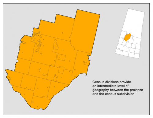
In other provinces and the territories ( N.L., Man., Sask. Alta., Y.T, N.W.T and Nvt.) where laws do not provide for such areas, Statistics Canada defines equivalent areas for statistical reporting purposes in cooperation with these provinces and territories.
Read more here.
This map shows a close-up view of one census division in Saskatchewan (Division No. 16) and its component census subdivisions. Source: Statistics Canada, Geography Division, 2016 Census of Population
Census subdivision (CSD)
Census subdivision (CSD) is the general term for municipalities (as determined by provincial/territorial or areas treated as municipal equivalents for statistical purposes (e.g., Indian reserves, Indian settlements and unorganized territories). Municipal status is defined by laws in effect in each province and territory in Canada. Read more here
Census Metropolitan area (CMA) and Census Agglomeration (CA)
Census metropolitan areas (CMAs) and census agglomerations (CAs) are deemed to be large, densely populated centres (known as the core) that comprise economically and socially integrated neighbouring municipalities.
A CMA must have a total population of at least 100,000 of which 50,000 or more must live in the core based on adjusted data from the previous Census of Population Program. A CA must have a core population of at least 10,000 also based on data from the previous Census of Population Program. Read more here.
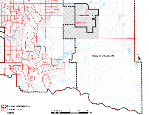
Census Tract (CTs)
Census tracts (CTs) are small, moderately stable geographic areas that usually have a population of less than 10,000 persons, based on data from the previous Census of Population Program. They are located in census metropolitan areas and in census agglomerations that had a core population of 50,000 or more in the previous census. Read more here.
| CMA/CA code – CT name | CMA/CA name |
|---|---|
| 562 0005.00 | Sarnia CA (Ont.) |
| 933 0005.00 | Vancouver CMA (B.C.) |
The map below shows that CT 825 0204.04 in the Calgary (Alberta) census metropolitan area encompasses all or part of three census subdivisions: Calgary (CY), Rocky View County (MD) and Chestermere (CY).


Be the first to comment