
Nowadays, satellite remote sensing comes in handy and can now be employed in our day-to-day activities. This technology, with the assistance of GPS and GIS, provides tools and analysis relevant to real-time road mapping and aerial photography, monitoring of air and water qualities, weather and land use changes detection, and remote area surveillance. I’m only naming a few things. The list of useful things you can do with remotely sensed data is endless.
However, to get the most out of this technology it helps to be familiar with two important elements. The data and the software tools themselves.
6 Remote Sensing Software Packages
Principally, every software offers exclusive features that complement your image processing work. Perhaps, a must-have in your work is a pixel-based algorithm for image analysis, an object-based algorithm integrated with segmentation or a combination of both. Moreover, you may also find supplementary image processes critical to your investigation, which geographically correct images and normalize pixel spectral values. You will always encounter these circumstances specifically on images that are captured over a complex environment where humidity level and cloud cover percentage are high, and shadow covers from high rising infrastructures are present as well.
| SOFTWARE | LINK |
|---|---|
| ENVI | l3harrisgeospatial.com |
| EDRAS | hexagongeospatial.com |
| PCI | catalyst.earth |
| eCOGNITION | geospatial.trimble.com |
| ESRI | esri.com |
| QGIS | qgis.com |
Sources of Data
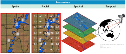
For image selection, you are essentially looking for four properties/ resolutions to consider.
Firstly, visualize that an image is composed of squares called pixels. A pixel is the smallest unit of an image and determines its spatial resolution. The smaller the pixel size, the higher the spatial resolution and provides you more detailed visual information.
Secondly, each pixel is assigned with a digital number that corresponds to its brightness intensity or spectral property and the range of values that can be assigned to it is known as the radial resolution.
Thirdly, the number of spectral regions of the electromagnetic radiation spectrum the satellite sensor can provide is known as the spectral resolution. Each spectral region represents a grayscale image of particular wavelength, frequency and energy, which can be composite with two other grayscale images to form multispectral images like true colour and false colour composites.
Lastly, the temporal resolution determines the satellite sensor acquisition frequency of images of the same Earth feature at a specific location.
The links on the table below direct you to different providers of satellite images. Some of them offer research agreement where you can access their image resources for free of cost. On the other hand, each imagery also has its unique features; therefore, it is advisable that you evaluate it first.
| IMAGE PROVIDERS | LINK |
|---|---|
| Planet | planet.com |
| DigitalGlobe Foundation/ Maxar | maxar.com |
| Landsat Time Series | earthexplorer.usgs.gov |
| Air Bus Space Agency | airbus.com |
I compiled some of the remote sensing projects I completed during my career below. Please let me know what your favorite remote sensing software tools are in the comments below.


Be the first to comment