• facebook
  • Twitter
  • Linkedin
  • Youtube
  • Linkedin Group
  • Post a Job
  • Post an Ad
  • Post an Event
  • Post a Directory Listing
  • Post a Press Release
  • Media Kit
  • My Account
  • Login
GoGeomatics
  • MAGAZINE
    • BIM & GIS
    • Community
    • Conference news
    • Earth Observation
    • Education & Careers
    • GEOAI
    • Announcements
    • Reality Capture & Lidar
    • Science
    • Technology
  • Directories
    • ASSOCIATION
    • INDUSTRY
    • EDUCATION
    • Open Data
  • EVENTS
    • GeoIgnite Events
    • Events Calendar
    • GoGeomatics Meetups
  • Services
    • Advertising
    • Marketing
    • Post a Job
    • Post an Ad
    • Post an Event
    • Post a Press Release
    • Post a Directory Listing
    • Media Kit
    • Web Design
  • Find a Job
  • Volunteer
    • Start a GoGeomatics Group
    • Editors & Writers Group
  • About Us
    • About Us
    • Contact Us
    • Frequently Asked Questions
  • Videos
HomeMAXAR

MAXAR

Earth Observation

NRCan’s Emergency Geomatics Service: A Federal leader in Disaster Management and Geointelligence

5 June 2025 Jake MacLean | Canada

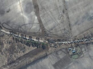
The need for rapid response to devastating natural disasters has always existed, but technological limitations have gotten in the way in the past. However, with the rapid development in Earth Observation capabilities in recent times, […]

Other

Thank You to All Our GeoIgnite 2025 Sponsors!

5 May 2025 GoGeomatics Canada | actionable intelligence

As GeoIgnite 2025 approaches, we extend our heartfelt thanks to all our sponsors whose support makes this premier Canadian geospatial leadership conference possible. Their commitment enables us to bring together experts, professionals, and innovators from […]

||
Earth Observation

Imagery, Intelligence, and the Changing Geopolitical Landscape

23 April 2025 Jake MacLean | BlackSky

Access to satellite imagery remains as important as ever At the beginning of the Russia-Ukraine war, it became clear that satellite imagery provided critical intelligence to Ukraine from leading companies such as Maxar, BlackSky, and […]

|PacGeo|Maxar satellite|Maxar satellite|
Earth Observation

Pacific Geomatics Brings Maxar’s WorldView Legion to Canadian Projects

11 April 2025 GoGeomatics Canada | constellation

Pacific Geomatics (PacGeo), a leading Canadian satellite imagery provider, is pleased to announce a limited-time special tasking promotion for Canadian organizations to access high-resolution satellite imagery at an outstanding value. Maxar Intelligence, a longstanding partner […]

Community

Maxar Joins Canada’s National Geomatics Expo as a Silver Sponsor & Exhibitor

29 August 2024 GoGeomatics Canada | 3d models

Maxar Intelligence has joined the National Geomatics Expo in Calgary as a silver sponsor, underscoring the significance of this event in the geospatial community. This partnership is a testament to the value that Maxar brings […]

Community

Building a Geomatics Expo in Canada

26 September 2023 Gavin Schrock | 3D Line Locating

GEOMATICS ● SURVEYING ● EARTH OBSERVATION ● REALITY CAPTURE & DIGITAL TWINS REMOTE SENSING ● BIM & GIS ● REALITY CAPTURE & DIGITAL TWINS EDUCATION ● LEADERSHIP ● GOVERNMENT I’m excited to be part of […]

Community

MAXAR Joins the GoGeomatics Expo

6 September 2023 GoGeomatics Expo | Archaeology GIS

  Maxar partners with innovative businesses and more than 50 governments to monitor global change, deliver broadband communications and advance space operations with capabilities in Space Infrastructure and Earth Intelligence. With more than 60 years […]

Technology

International Geospatial Digest August 28, 2023

28 August 2023 Volunteer Editors and Group Writers | 3D Mapping

Ordnance Survey partners with OxTS Aerial imagery maps historic archaeology of South Downs Maxar and Esri expand partnership, adding Precision3D in the Living Atlas of the World How Kaua’i County uses GIS to future-proof development […]

Posts pagination

1 2 … 6 »

Events

Notice
There are no upcoming events.

View All Events

Services

  • Post a Job
  • Post an Ad
  • Post an Event
  • Post a Directory Listing
  • Post a Press Release
  • Media Kit
  • My Account
  • Login

Jobs

Post a Job
  • Canada Maps and Poster Gallery Volunteer Leads — GeoIgnite 2026
    remote
  • GIS & Data Analytics Lead
    Beaumont, AB
  • Lead Surveyor, Projects/Arpenteur-géomètre principal, projets; arpenteuse-géomètre principale, projets
    North Bay, Thunder Bay
  • Senior GIS Developer
    Calgary, AB
View All Jobs
  • Directories
    • Associations Directory
    • Industry Directory
    • Education Programs
    • Open Data
  • Volunteer
    • Start a GoGeomatics Group
    • Editors & Writers Group
  • About Us
    • GoGeomatics Media Kit
    • Who We Are
    • Contact Us
    • FAQ’s
    • Advertising
    • Marketing
  • Subscribe
GoGeomatics
GoGeomatics is the largest and most popular communications hub promoting the Canadian geospatial community. The business was incorporated in 2011. GoGeomatics hosts over 100 fun, free, location technology networking events each year in cities across Canada.

© 2025 GoGeomatics

  • facebook
  • Twitter
  • Linkedin
  • Youtube
  • Linkedin Group