• facebook
  • Twitter
  • Linkedin
  • Youtube
  • Linkedin Group
  • Post a Job
  • Post an Ad
  • Post an Event
  • Post a Directory Listing
  • Post a Press Release
  • Media Kit
  • My Account
  • Login
GoGeomatics
  • MAGAZINE
    • BIM & GIS
    • Community
    • Conference news
    • Earth Observation
    • Education & Careers
    • GEOAI
    • Announcements
    • Reality Capture & Lidar
    • Science
    • Technology
  • Directories
    • ASSOCIATION
    • INDUSTRY
    • EDUCATION
    • Open Data
  • EVENTS
    • GeoIgnite Events
    • Events Calendar
    • GoGeomatics Meetups
  • Services
    • Advertising
    • Marketing
    • Post a Job
    • Post an Ad
    • Post an Event
    • Post a Press Release
    • Post a Directory Listing
    • Media Kit
    • Web Design
  • Find a Job
  • Volunteer
    • Start a GoGeomatics Group
    • Editors & Writers Group
  • About Us
    • About Us
    • Contact Us
    • Frequently Asked Questions
  • Videos
HomeNDVI

NDVI

Earth Observation

CanadaFireSat: The Future of Wildfire Resilience in Canada

26 June 2025 Alefiya Dungrawala | boreal communities

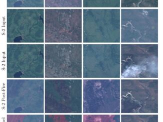
Year 2023 has witnessed the most devastating wildfire season that Canada has experienced in recent history. An unprecedented amount of damage has been inflicted on ecosystems and surrounding boreal communities, resulting in massive quantities of […]

||||||
Education & Careers

Geospatial Earth Observation Using Blimps, Balloons and Kites

7 February 2017 Theresa Pinter | 2012

These days drones are all the rage. Nevertheless, there are other ways to collect data from the sky! Blimps, balloons and kites are alternative was to collecting data or remote-sensing imagery. These are great unconventional solutions for […]

No Picture
Newsmakers & Press Releases

SimActive Announces Correlator3DTM Version 6.2

1 September 2015 GoGeomatics Newsmakers | 2015

Montreal, Canada, September 1st, 2015 – SimActive Inc., a world-leading developer of photogrammetry software, is pleased to announce Correlator3D™ version 6.2, featuring a new module for tie point editing during aerial triangulation. Users can visually […]

No Picture
Community

Global Commercial Drone Market to Reach $2.07 Billion by 2022

18 August 2015 GoGeomatics Newsmakers | 2012

The global commercial drone market size is expected to reach USD 2.07 billion by 2022, according to a new report by Grand View Research, Inc. Increased utility in law enforcement and agricultural applications is expected […]

No Picture
Newsmakers & Press Releases

PrecisionHawk and Agri-Trend Partner to Offer First, Full Service Drone and Data Solution to Farmers

9 March 2015 GoGeomatics Newsmakers | 2016

Agri-Trend clients will have access to the PrecisionHawk Drone Platform, Sensors and Data Mapping tools with the expectation to fully commercialize, across the US and Canada, in 2016 PrecisionHawk and Agri-Trend announced a partnership to […]

No Picture
Community

Geomatics & Hockey – Only in Canada

15 October 2013 Tyler Collins | alberta

This time of year there is no shortage of magazines and web sites devoting space to articles on hockey. There are currently several season previews available that provide predictions on who will win the Stanley […]

Events

Notice
There are no upcoming events.

View All Events

Services

  • Post a Job
  • Post an Ad
  • Post an Event
  • Post a Directory Listing
  • Post a Press Release
  • Media Kit
  • My Account
  • Login

Jobs

Post a Job
  • Canada Maps and Poster Gallery Volunteer Leads — GeoIgnite 2026
    remote
  • GIS & Data Analytics Lead
    Beaumont, AB
  • Lead Surveyor, Projects/Arpenteur-géomètre principal, projets; arpenteuse-géomètre principale, projets
    North Bay, Thunder Bay
  • Senior GIS Developer
    Calgary, AB
View All Jobs
  • Directories
    • Associations Directory
    • Industry Directory
    • Education Programs
    • Open Data
  • Volunteer
    • Start a GoGeomatics Group
    • Editors & Writers Group
  • About Us
    • GoGeomatics Media Kit
    • Who We Are
    • Contact Us
    • FAQ’s
    • Advertising
    • Marketing
  • Subscribe
GoGeomatics
GoGeomatics is the largest and most popular communications hub promoting the Canadian geospatial community. The business was incorporated in 2011. GoGeomatics hosts over 100 fun, free, location technology networking events each year in cities across Canada.

© 2025 GoGeomatics

  • facebook
  • Twitter
  • Linkedin
  • Youtube
  • Linkedin Group