
Community
Open Data, Open Source, Open Possibilities
Back in 2006 I (Jim) was a student at BCIT and a Vancouver resident, eager to obtain some local data for a project. I sent a hopeful email to City of Vancouver (COV) requesting the […]
Back in 2006 I (Jim) was a student at BCIT and a Vancouver resident, eager to obtain some local data for a project. I sent a hopeful email to City of Vancouver (COV) requesting the […]
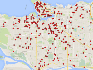
A friend of mine who volunteers with a girls’ softball team came to me with a request recently. “I have the addresses of all of the girls in our softball league”, she said. “I want […]
This article is the first in a monthly GoGeomatics Canada series on topics related to Open Source GIS for Everyone, by Rick Davidson and Jim O’Leary, Continuing Studies (CS) instructors at Langara College in Vancouver, […]

Last year, we brought you our recommendations for 10 geomatics LinkedIn groups you should be following. This year, there were so many influential groups to choose from, that we updated and expanded that list to […]
GoGeomatics Canada is presenting a free day-long seminar for QGIS in Ottawa April 5th at the Sunnyside library. QGIS is a user friendly Open Source Geographic Information System (GIS) licensed under the GNU General Public […]
Anderson Sandes has brought a vast background in GIS to GoGeomatics and we are pleased to introduce him as one of our Vancouver social leaders. He is currently a technical writer and researcher in the […]
GoGeomatics recently had the pleasure of speaking with a creative cartographer who has a passion for paper maps. Find out how Meghan came to her current position with Canadian Cartographics Corporation (CCC) and what led […]
Interest in mapping is on the rise, as evidenced by services such as Google Earth, Virtual Earth, MapQuest, and any number of other web mapping mashups. These are all exciting developments, yet there is another […]