• facebook
  • Twitter
  • Linkedin
  • Youtube
  • Linkedin Group
  • Post a Job
  • Post an Ad
  • Post an Event
  • Post a Directory Listing
  • Post a Press Release
  • Media Kit
  • My Account
  • Login
GoGeomatics
  • MAGAZINE
    • BIM & GIS
    • Community
    • Conference news
    • Earth Observation
    • Education & Careers
    • GEOAI
    • Announcements
    • Reality Capture & Lidar
    • Science
    • Technology
    • Between the Poles
  • Directories
    • ASSOCIATION
    • INDUSTRY
    • EDUCATION
    • Open Data
  • EVENTS
    • GeoIgnite Events
    • Events Calendar
    • GoGeomatics Meetups
  • Services
    • Advertising
    • Marketing
    • Post a Job
    • Post an Ad
    • Post an Event
    • Post a Press Release
    • Post a Directory Listing
    • Media Kit
    • Web Design
  • Find a Job
  • Volunteer
    • Start a GoGeomatics Group
    • Editors & Writers Group
  • About Us
    • About Us
    • Contact Us
    • Frequently Asked Questions
  • Videos
HomeOpen Source

Open Source

No Picture
Community

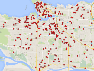
Vancouver: Using QGIS TimeManager for Analysis of Crime Data

21 January 2016 GIS Program Langara CS | 2014

We typically think of a GIS as features on a map with a maximum of three dimensions: Longitude Latitude Height However, there is another dimension that we can add to features, and that is time. […]

No Picture
Community

Map Tiles and Cached Map Services

6 December 2015 Emmanuel Stefanakis | 2015

  The tiling of large maps is an old practice. Large paper maps have always been divided into a series of map sheets at various scales. With the increasing popularity of web mapping applications and […]

No Picture
Community

Open Data, Open Source, Open Possibilities

4 December 2015 GIS Program Langara CS | 2013

Back in 2006 I (Jim) was a student at BCIT and a Vancouver resident, eager to obtain some local data for a project. I sent a hopeful email to City of Vancouver (COV) requesting the […]

No Picture
Technology

QGIS, GDAL & Python: Exploring The Lost Buildings of Ottawa

11 November 2015 Kevin Ballantyne | api

The city of Ottawa has seen its urban landscape change throughout its history. As in many major cities, small buildings have been replaced with larger ones as the city grew. After Ottawa was chosen as […]

||
Education & Careers

Getting to First Base with GIS

10 November 2015 GIS Program Langara CS | analysis

A friend of mine who volunteers with a girls’ softball team came to me with a request recently. “I have the addresses of all of the girls in our softball league”, she said. “I want […]

No Picture
Education & Careers

Open Source GIS for Everyone: A QGIS-based program at Langara College Vancouver

8 October 2015 GIS Program Langara CS | 2013

This article is the first in a monthly GoGeomatics Canada series on topics related to Open Source GIS for Everyone, by Rick Davidson and Jim O’Leary, Continuing Studies (CS) instructors at Langara College in Vancouver, […]

|
Community

BCIT Program Has the GIS Talent You Need

28 August 2015 Karl Kliparchuk | 2014

The BCIT GIS department has been graduating students for 25+ years.  Our students come from BC, but as well, across Canada and international.  Our program is known to be very demanding, and creates students that […]

No Picture
Community

Quebec Launches new FOSS4G GIS called IGO

18 August 2015 GoGeomatics Newsmakers | api

IGO (for Open GIS Infrastructure) is a Free Open Source Software for Geospatial (FOSS4G) developed by organisations in the government of Quebec in Canada. The objective is to make it open, common, modular, based on […]

Posts pagination

« 1 … 5 6 7 … 10 »

Events

Notice
There are no upcoming events.

View All Events

Services

  • Post a Job
  • Post an Ad
  • Post an Event
  • Post a Directory Listing
  • Post a Press Release
  • Media Kit
  • My Account
  • Login

Jobs

Post a Job
  • Operations Spatial Data Assistant (Contract)
    Vaughan
  • GIS Analyst
    Saint John, New Brunswick
  • GIS Student Intern
    Elmsdale, Nova Scotia
  • Canada Impact+ Research Chair – Professor (Or Associate Professor)
    Lethbridge, Alberta
View All Jobs
  • Directories
    • Associations Directory
    • Industry Directory
    • Education Programs
    • Open Data
  • Volunteer
    • Start a GoGeomatics Group
    • Editors & Writers Group
  • About Us
    • GoGeomatics Media Kit
    • Who We Are
    • Contact Us
    • FAQ’s
    • Advertising
    • Marketing
  • Subscribe
GoGeomatics
GoGeomatics is the largest and most popular communications hub promoting the Canadian geospatial community. The business was incorporated in 2011. GoGeomatics hosts over 100 fun, free, location technology networking events each year in cities across Canada.

© 2026 GoGeomatics

  • facebook
  • Twitter
  • Linkedin
  • Youtube
  • Linkedin Group