• facebook
  • Twitter
  • Linkedin
  • Youtube
  • Linkedin Group
  • Post a Job
  • Post an Ad
  • Post an Event
  • Post a Directory Listing
  • Post a Press Release
  • Media Kit
  • My Account
  • Login
GoGeomatics
  • MAGAZINE
    • BIM & GIS
    • Community
    • Conference news
    • Earth Observation
    • Education & Careers
    • GEOAI
    • Announcements
    • Reality Capture & Lidar
    • Science
    • Technology
  • Directories
    • ASSOCIATION
    • INDUSTRY
    • EDUCATION
    • Open Data
  • EVENTS
    • GeoIgnite Events
    • Events Calendar
    • GoGeomatics Meetups
  • Services
    • Advertising
    • Marketing
    • Post a Job
    • Post an Ad
    • Post an Event
    • Post a Press Release
    • Post a Directory Listing
    • Media Kit
    • Web Design
  • Find a Job
  • Volunteer
    • Start a GoGeomatics Group
    • Editors & Writers Group
  • About Us
    • About Us
    • Contact Us
    • Frequently Asked Questions
  • Videos
Homeorder

order

|||||||||||||||||
Technology

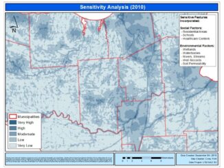
Landfill Assessment and Sensitivity Mapping Project

11 January 2013 Corey | air photo

Project Task: Locate and collect information about open, closed, and historic landfills in order to create a 5 years inspection plan GIS Tools used: ArcInfo v9.3, Spatial Analyst Toolbar, Georeferencing Toolbar Datasets: Rivers, Lakes, Wetlands, Well Records, Soil […]

Leica GPS survey control base|RTK GPS base|Grey Jay in Labrador landing on the radio tripod|||||||||
Education & Careers

Where will your Geomatics Career Bring You?

12 December 2012 T Mackinnon | advice

“Should you Specialize or Diversify?” Something many of us in geomatics often come across in our careers is whether or not we should be specialized on a specific geomatics aspect (like a certain software or skill set)  or […]

||Jacques Cartier's Route of Exploration|David Thompson|David Thompson's Route of Exploration|||||Map showing the routes of various Great Explorers
Community

Top Five Canadian Explorers/ Mappers/ Surveyors

5 December 2012 Marcus Hinds | Aboriginal

Modern Canada is internationally renowned for its cartographic practices and strong mapping systems. Canada is host to vast landscapes and diverse in climates and topography.  These lands and waters were  mapped and surveyed, by many […]

No Picture
Community

“Bands” Around Edges Of Polygons – ArcGIS Online Tip

13 November 2012 David | 2012

The essence of this article is: preparing a thick border around polygons for display on ArcGIS Online (but also in ArcMap); note I am using what is now – Nov 2012 – referred to as […]

Education & Careers

Cartographic Specialist or Applications Specialist: That Is The Question.

12 November 2012 Chelsea Gurr | adventure

Well, at least for a post-grad GIS student… Having recently graduated from the University of Ottawa with a BA Honors in Geography, the next step for me was clear. Although I achieved a minor in […]

Community

Canada’s Arctic: Spatial Info/Geotech Opportunity

1 October 2012 Jeff_Thurston | activity

Canada’s north has always been a challenge to those living there and to geoscience professionals alike. The sheer size of the arctic and extreme cold have resulted in difficult access and contributed toward significant challenges […]

Technology

The Ottawa Tree Canopy Cover Mapping Project

28 September 2012 Regie | 2012

The City of Ottawa Official Plan set a target of 30% tree canopy cover for the entire city. To the author’s knowledge there is no information on the amount of tree canopy for the entire […]

|
Education & Careers

Lawrie Keillor-Faulkner: GIS Instructor, Fleming College

20 September 2012 Lawrie | 2012

GoGeomatics Canada is talking to Lawrie Keillor-Faulkner a member of the GIS Faculty at Fleming College in Ontario. GoGeomatics: Welcome to the GoGeomatics Canada community. To get started can you tell us about where you […]

Posts pagination

« 1 … 18 19 20 21 »

Events

Notice
There are no upcoming events.

View All Events

Services

  • Post a Job
  • Post an Ad
  • Post an Event
  • Post a Directory Listing
  • Post a Press Release
  • Media Kit
  • My Account
  • Login

Jobs

Post a Job
  • Canada Maps and Poster Gallery Volunteer Leads — GeoIgnite 2026
    remote
  • GIS & Data Analytics Lead
    Beaumont, AB
  • Lead Surveyor, Projects/Arpenteur-géomètre principal, projets; arpenteuse-géomètre principale, projets
    North Bay, Thunder Bay
  • Senior GIS Developer
    Calgary, AB
View All Jobs
  • Directories
    • Associations Directory
    • Industry Directory
    • Education Programs
    • Open Data
  • Volunteer
    • Start a GoGeomatics Group
    • Editors & Writers Group
  • About Us
    • GoGeomatics Media Kit
    • Who We Are
    • Contact Us
    • FAQ’s
    • Advertising
    • Marketing
  • Subscribe
GoGeomatics
GoGeomatics is the largest and most popular communications hub promoting the Canadian geospatial community. The business was incorporated in 2011. GoGeomatics hosts over 100 fun, free, location technology networking events each year in cities across Canada.

© 2025 GoGeomatics

  • facebook
  • Twitter
  • Linkedin
  • Youtube
  • Linkedin Group