• facebook
  • Twitter
  • Linkedin
  • Youtube
  • Linkedin Group
  • Post a Job
  • Post an Ad
  • Post an Event
  • Post a Directory Listing
  • Post a Press Release
  • Media Kit
  • My Account
  • Login
GoGeomatics
  • MAGAZINE
    • BIM & GIS
    • Community
    • Conference news
    • Earth Observation
    • Education & Careers
    • GEOAI
    • Announcements
    • Reality Capture & Lidar
    • Science
    • Technology
  • Directories
    • ASSOCIATION
    • INDUSTRY
    • EDUCATION
    • Open Data
  • EVENTS
    • GeoIgnite Events
    • Events Calendar
    • GoGeomatics Meetups
  • Services
    • Advertising
    • Marketing
    • Post a Job
    • Post an Ad
    • Post an Event
    • Post a Press Release
    • Post a Directory Listing
    • Media Kit
    • Web Design
  • Find a Job
  • Volunteer
    • Start a GoGeomatics Group
    • Editors & Writers Group
  • About Us
    • About Us
    • Contact Us
    • Frequently Asked Questions
  • Videos
Homepandemic

pandemic

||
Technology

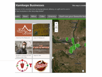
COVID-19: Supporting Kamloops, BC businesses using Story Maps

18 June 2020 Saeideh Hejazi | ArcGIS Online

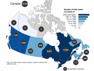
In the middle of March 2020, COVID-19 pandemic leads to social distancing rules in Canada. Public areas such as restaurants are closed. Some restaurants in Kamloops city in British Columbia have been working through takeout […]

||||
Technology

Your Canadian Geospatial Briefing for June 15th: Canadian Drone delivery solution; City of Montreal open data; Tagged leatherback sea turtles; Endangered Fish in BC

15 June 2020 GoGeomatics Canada | api

Drone company will convey COVID-19 medical equipment to First Nation Drone Delivery Canada (DDC) will transport COVID-19 medical products using Sparrow drone to Beausoleil First Nation (BSN) community located at the southern tip of Georgian […]

Surveying Mount Everest|||
Technology

Your International Geospatial Briefing for June 8th: NZ Lego Map; Mapping COVID-19 Stories; Monitoring Lakes with Remote Sensing; Chinese Surveyors Reach Everest; Geospatial Analysis of COVID-19

8 June 2020 GoGeomatics Canada | COVID-19

Data analyst’s incredible NZ Lego map made with 3600 bricks German Alex Waleczek, who lives in New Zealand, made an accurate 3D model of a map of New Zealand. The map is 90cm x 128cm […]

Community

GeoIgnite 2020 Online; Canada’s National Geospatial Leadership Conference: An Interview with Jonathan Murphy

8 June 2020 T Mackinnon | Canada

GeoIgnite Online 2020: The theme for this year is (no surprise): Leadership In Times of Disruption Next month the Canadian geospatial community will gather online for this year’s GeoIgnite 2020.  Join Ted Mackinnon (Member of […]

|
Technology

Coronavirus Maps of Canada

16 April 2020 GoGeomatics Canada | Canada

What follow is a list of websites that are hosting online maps of the coronavirus in Canada. As our community is all about the maps I would be curious as to what you think is […]

|
Community

Live Map with Updates Coronavirus (COVID-19) situation

27 February 2020 Jon Murphy | Canada

You can find the latest facts and figures using this ArcGIS live update map below for the coronavirus. Here are a few links that might be helpful if you are looking for information from the […]

Posts pagination

« 1 2

Events

Notice
There are no upcoming events.

View All Events

Services

  • Post a Job
  • Post an Ad
  • Post an Event
  • Post a Directory Listing
  • Post a Press Release
  • Media Kit
  • My Account
  • Login

Jobs

Post a Job
  • Canada Maps and Poster Gallery Volunteer Leads — GeoIgnite 2026
    remote
  • GIS & Data Analytics Lead
    Beaumont, AB
  • Lead Surveyor, Projects/Arpenteur-géomètre principal, projets; arpenteuse-géomètre principale, projets
    North Bay, Thunder Bay
  • Senior GIS Developer
    Calgary, AB
View All Jobs
  • Directories
    • Associations Directory
    • Industry Directory
    • Education Programs
    • Open Data
  • Volunteer
    • Start a GoGeomatics Group
    • Editors & Writers Group
  • About Us
    • GoGeomatics Media Kit
    • Who We Are
    • Contact Us
    • FAQ’s
    • Advertising
    • Marketing
  • Subscribe
GoGeomatics
GoGeomatics is the largest and most popular communications hub promoting the Canadian geospatial community. The business was incorporated in 2011. GoGeomatics hosts over 100 fun, free, location technology networking events each year in cities across Canada.

© 2025 GoGeomatics

  • facebook
  • Twitter
  • Linkedin
  • Youtube
  • Linkedin Group