• facebook
  • Twitter
  • Linkedin
  • Youtube
  • Linkedin Group
  • Post a Job
  • Post an Ad
  • Post an Event
  • Post a Directory Listing
  • Post a Press Release
  • Media Kit
  • My Account
  • Login
GoGeomatics
  • MAGAZINE
    • BIM & GIS
    • Community
    • Conference news
    • Earth Observation
    • Education & Careers
    • GEOAI
    • Announcements
    • Reality Capture & Lidar
    • Science
    • Technology
  • Directories
    • ASSOCIATION
    • INDUSTRY
    • EDUCATION
    • Open Data
  • EVENTS
    • GeoIgnite Events
    • Events Calendar
    • GoGeomatics Meetups
  • Services
    • Advertising
    • Marketing
    • Post a Job
    • Post an Ad
    • Post an Event
    • Post a Press Release
    • Post a Directory Listing
    • Media Kit
    • Web Design
  • Find a Job
  • Volunteer
    • Start a GoGeomatics Group
    • Editors & Writers Group
  • About Us
    • About Us
    • Contact Us
    • Frequently Asked Questions
  • Videos
Homephda

phda

|
Newsmakers & Press Releases

The role GIS has played in the COVID-19 Coronavirus Outbreak

2 March 2020 Joey Syer | Ausenco

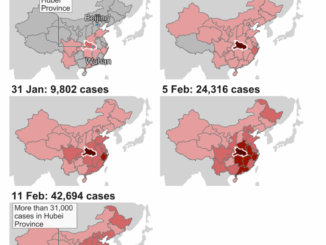
COVID-19 (a new corona virus) topped news headlines in early 2020 when it broke out in Wuhan, China. The outbreak quickly became an international concern, and on January 30th, 2020 it was declared a Public […]

|
Education & Careers

Using GIS to study health care services and utilization––from local to national

24 July 2017 Anders Erickson | communication

Access to timely and quality health care is an important determinant of health and well-being. Despite universal health coverage in Canada, there exists socio-demographic, financial and physical geographic barriers that limit the accessibility to health […]

|
Education & Careers

It’s a Geospatial world we live in: Find Your Happy Place

1 November 2016 Anders Erickson | analysis

When does a space become a place? There are a myriad of small open spaces and buildings throughout towns and cities across Canada that offer places for play, walking, social gathering, and contemplation that are […]

No Picture
Community

GIS Health Studies: Conduct Spatial Exposure Assessments

5 September 2016 Anders Erickson | 2016

Interested in how to conduct different types of spatial exposure assessments for air pollution or other exposures to a population?  PHDA04: Spatial Epidemiology and Outbreak Detection is a great place to start. Exposure assessment is the […]

|||Cluster Map of Spatial Autocorrelation
Community

University of Victoria Hosts Advanced Spatial Analysis Course

20 July 2016 Anders Erickson | 2016

Is neighbourhood socioeconomic status associated with pediatric and childhood injuries? Are such injuries clustered in space? How can I model the spatial dependence in pediatric and childhood injuries in order to help policy makers develop […]

Education & Careers

Professional Certification: Population Health Data Analysis in British Columbia

22 March 2016 Anders Erickson | 2016

Population health research is inherently interdisciplinary, multifaceted and firmly rooted in the evolving connections between place, time and related socioeconomic processes. To excel in this rapidly diversifying field requires a broad range of skills. The […]

Events

Notice
There are no upcoming events.

View All Events

Services

  • Post a Job
  • Post an Ad
  • Post an Event
  • Post a Directory Listing
  • Post a Press Release
  • Media Kit
  • My Account
  • Login

Jobs

Post a Job
  • Canada Maps and Poster Gallery Volunteer Leads — GeoIgnite 2026
    remote
  • GIS & Data Analytics Lead
    Beaumont, AB
  • Lead Surveyor, Projects/Arpenteur-géomètre principal, projets; arpenteuse-géomètre principale, projets
    North Bay, Thunder Bay
  • Senior GIS Developer
    Calgary, AB
View All Jobs
  • Directories
    • Associations Directory
    • Industry Directory
    • Education Programs
    • Open Data
  • Volunteer
    • Start a GoGeomatics Group
    • Editors & Writers Group
  • About Us
    • GoGeomatics Media Kit
    • Who We Are
    • Contact Us
    • FAQ’s
    • Advertising
    • Marketing
  • Subscribe
GoGeomatics
GoGeomatics is the largest and most popular communications hub promoting the Canadian geospatial community. The business was incorporated in 2011. GoGeomatics hosts over 100 fun, free, location technology networking events each year in cities across Canada.

© 2025 GoGeomatics

  • facebook
  • Twitter
  • Linkedin
  • Youtube
  • Linkedin Group