• facebook
  • Twitter
  • Linkedin
  • Youtube
  • Linkedin Group
  • Post a Job
  • Post an Ad
  • Post an Event
  • Post a Directory Listing
  • Post a Press Release
  • Media Kit
  • My Account
  • Login
GoGeomatics
  • MAGAZINE
    • BIM & GIS
    • Community
    • Conference news
    • Earth Observation
    • Education & Careers
    • GEOAI
    • Announcements
    • Reality Capture & Lidar
    • Science
    • Technology
  • Directories
    • ASSOCIATION
    • INDUSTRY
    • EDUCATION
    • Open Data
  • EVENTS
    • GeoIgnite Events
    • Events Calendar
    • GoGeomatics Meetups
  • Services
    • Advertising
    • Marketing
    • Post a Job
    • Post an Ad
    • Post an Event
    • Post a Press Release
    • Post a Directory Listing
    • Media Kit
    • Web Design
  • Find a Job
  • Volunteer
    • Start a GoGeomatics Group
    • Editors & Writers Group
  • About Us
    • About Us
    • Contact Us
    • Frequently Asked Questions
  • Videos
Homepoints

points

||
Education & Careers

Getting to First Base with GIS

10 November 2015 GIS Program Langara CS | analysis

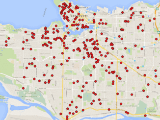
A friend of mine who volunteers with a girls’ softball team came to me with a request recently. “I have the addresses of all of the girls in our softball league”, she said. “I want […]

No Picture
Community

GIS: Adventures in Historical Mapping

2 November 2015 Bert V. de Bruijn | advancement

This article focuses on the process of creating a very out-of-date map in GIS. Lots has gone on since I posted Gettysburg: What Could Lee See? last summer. Technology continues to evolve at a dizzying […]

No Picture
Technology

Elevation Web Services: Limitations and Prospects

2 November 2015 Emmanuel Stefanakis | 2014

Elevation Web Services: Limitations and Prospects Elevation data is necessary for a wide range of geospatial applications such as creating relief maps and rendering 3D visualizations, deriving the slope and aspect of a geographic area, […]

No Picture
Newsmakers & Press Releases

Teledyne Optech a sponsor at 2015 Asian Conference on Remote Sensing

15 October 2015 GoGeomatics Newsmakers | 2015

October 14, 2015 — Teledyne Optech is pleased to announce we are a sponsor at the Asian Conference on Remote Sensing (ACRS) taking place on October 19-23 in Quezon City, the Philippines. At the show […]

No Picture
Newsmakers & Press Releases

GIS: Parks Canada Receives Award for Enterprise Approach to Data Management

7 October 2015 GoGeomatics Newsmakers | 2015

OTTAWA, Esri Canada User Conference – October 6, 2015 – Parks Canada fosters public understanding, appreciation and enjoyment of Canada’s natural and cultural heritage for present and future generations. The Agency manages national parks, national […]

No Picture
Newsmakers & Press Releases

SimActive Announces Correlator3DTM Version 6.2

1 September 2015 GoGeomatics Newsmakers | 2015

Montreal, Canada, September 1st, 2015 – SimActive Inc., a world-leading developer of photogrammetry software, is pleased to announce Correlator3D™ version 6.2, featuring a new module for tie point editing during aerial triangulation. Users can visually […]

|
Community

Point, Hub, Link, Node: The Unique Geography of Airports & Pearson

25 June 2015 Richard D. Quodomine | 2014

When we go to the airport, do we really ever consider where we’re going? To most of us, even those who love transportation geography, an airport is a dot on a map. However, Toronto Pearson […]

|||
Technology

PredictION: Routing & Modeling App for Proposed Transit Projects

17 June 2015 Team PredictION | 2015

PredictION is an app that provides transit authorities with a unique approach to engage and inform the public. By making use of General Transit Feed Specifications, PredictION will allow users to predict the impacts of […]

Posts pagination

« 1 … 3 4 5 … 12 »

Events

Notice
There are no upcoming events.

View All Events

Services

  • Post a Job
  • Post an Ad
  • Post an Event
  • Post a Directory Listing
  • Post a Press Release
  • Media Kit
  • My Account
  • Login

Jobs

Post a Job
  • Canada Maps and Poster Gallery Volunteer Leads — GeoIgnite 2026
    remote
  • GIS & Data Analytics Lead
    Beaumont, AB
  • Lead Surveyor, Projects/Arpenteur-géomètre principal, projets; arpenteuse-géomètre principale, projets
    North Bay, Thunder Bay
  • Senior GIS Developer
    Calgary, AB
View All Jobs
  • Directories
    • Associations Directory
    • Industry Directory
    • Education Programs
    • Open Data
  • Volunteer
    • Start a GoGeomatics Group
    • Editors & Writers Group
  • About Us
    • GoGeomatics Media Kit
    • Who We Are
    • Contact Us
    • FAQ’s
    • Advertising
    • Marketing
  • Subscribe
GoGeomatics
GoGeomatics is the largest and most popular communications hub promoting the Canadian geospatial community. The business was incorporated in 2011. GoGeomatics hosts over 100 fun, free, location technology networking events each year in cities across Canada.

© 2025 GoGeomatics

  • facebook
  • Twitter
  • Linkedin
  • Youtube
  • Linkedin Group