Technology
The Innovation of Geocoding
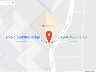
According to Esri, a geocode transforms a description of a location to a real location on the Earth. The description can be an address, coordinates, or a name of a place. It is an essential […]
According to Esri, a geocode transforms a description of a location to a real location on the Earth. The description can be an address, coordinates, or a name of a place. It is an essential […]

Awareness for climate change has been steadily increasing ever since the Green Revolution in the 1960s. There is a plethora of data, maps, and Geographic Information Systems (GIS) applications available freely or accessible to the […]
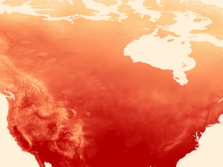
There has never been a time in the history of GIS when so much free, high quality data has been available. As an example, the WorldClim site (http://www.worldclim.org/) offers temperature raster data, on a global […]
Interested in how to conduct different types of spatial exposure assessments for air pollution or other exposures to a population? PHDA04: Spatial Epidemiology and Outbreak Detection is a great place to start. Exposure assessment is the […]
Have you ever felt the wrath of a Canadian Crown Corporation? In 2011 Canada Post set its sights on Ervin Ruci and by 2012 had sued him personally for copyright infringement. The copyright Canada Post […]
by Ed Kennedy and Evert Kenk. Is there value in formalizing definitions for both the Geomatics Sector and Geospatial Community that capture a meaningful relationship between the two? The ongoing Geomatics versus Geospatial debate once […]
The open data movement has been the talk of the nation, encouraging transparency of governance and good management of data. Goodness, what a magical moment it must be to witness the head of a government […]
Caliper is excited to announce a new Canada Data Package! The product includes a wealth of data and functionality not available in any other software. The Canada data includes an up-to-date street layer with address […]