Community
Wanted – A GNSS Puck
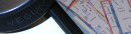
“I want it! I want it! I want it!” – “Magic Bus” – The Who The Glass Floor. There is glass floor of precision and accuracy that has sometimes been a hindrance to geospatial field […]
“I want it! I want it! I want it!” – “Magic Bus” – The Who The Glass Floor. There is glass floor of precision and accuracy that has sometimes been a hindrance to geospatial field […]

PCI Geomatics, a world-leading developer of remote sensing and photogrammetric software and systems, announces that its Mexican partner, Cloud Mapping Technologies (CMT) has selected the high-speed, automated GeoImaging Accelerator (GXL) image processing system to power […]
GAC 2015 Supports the GIS Education Community Everything begins and ends with geospatial information. Now more than ever, GIS and geomatics methodologies are gaining wide acceptance and adoption. GIS and geomatics tools were once […]
McElhanney Consulting Services Ltd. of Vancouver has acquired North Vancouver-based Infinity Engineering Group Ltd., specializing in bridge design and erection engineering. Infinity has played key roles in an impressive portfolio of long-span and complex bridges […]
EDC Provides Hispasat with Euro 123 M to Purchase a Satellite from Vancouver’s MDA Export Development Canada (EDC) today announced financing of Euro 123 M to Hispasat, a Spanish satellite telecommunications operator, for the construction […]
PCI Geomatics, a world leading developer of remote sensing and photogrammetric software and systems, announced today that it has been awarded a contract from the Canadian Space Agency to develop a commercial end-to-end interferometric processing […]
VANCOUVER – UrtheCast Corp. (TSX:UR) (“UrtheCast” or the “Company”) is pleased to announce that its President and COO, Wade Larson, will present at World Satellite Business Week in Paris, France on Thursday September 11, 2014 at […]
Satellite-based Earth Observation (EO) is a process of using remote-sensing technique to gather information on the chemical, physical and biological aspects of the earth system. This technique allows the measurement of geophysical parameters of the […]