GAC 2015 Supports the GIS Education Community
Everything begins and ends with geospatial information. Now more than ever, GIS and geomatics methodologies are gaining wide acceptance and adoption. GIS and geomatics tools were once used by surveyors who mapped and charted land and water. However, as technology advances and GIS gains popularity, the tools are now expanding range as organizations seek to discover the many uses of GIS, from integration of services to asset management to increased efficiency. GAC 2015 supports the GoGeomatics socials and the GIS education community because we are dedicated to the exchange of knowledge and best practice sharing that will aid in the progression of geomatics in Canada. New technologies are offering immense opportunities for the power of GIS including, but not limited to, big data analytics and advanced remote sensing capabilities including data collection through radar, satellites, LiDAR, and aerial photography
Remote sensing capabilities are experiencing a boom and geomatics practitioners are eager to find out more. Remote sensing covers a range of data collection methods in which spatial data is collected without making physical contact with an object; this is predominantly done through earth-observing satellites and UAVs. UAVs utilize a variety of data-collection technologies to capture spatial data, including LiDAR, aerial photography, RADAR, sonar and hyperspectral technology. The agriculture sector is becoming one of the earliest adopters of these new technologies and they are quickly expanding in reach.
Investments Made in Exploring Canada’s North
New geomatics methods are necessary to uncover opportunities in Canada’s North and beyond. Spatial information contributes billions of dollars to the Canadian economy.Federal agencies involved in this exploration include, but are not limited to: Joint Task Force North, The Canadian Ice Service, The Canadian Polar Commission, and the Canadian Coast Guard. Joint Task Force North will provide a timely update to challenges of exploration in the North at the forthcoming Geospatial Advancement Canada event while the Canadian Ice Service will follow up with suggestions for developing a common production system for Arctic Products.
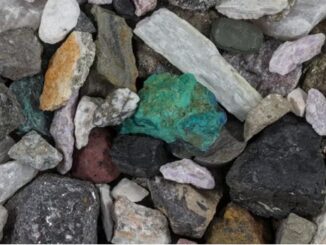
The Canadian government is committed to helping reveal the full energy and mineral potential of the North, as well as to promoting responsible land development in the region. In August of 2013, Prime Minister Stephen Harper announced renewed support of $100 million over seven years (2013-2020) for the Geo-mapping for Energy and Minerals (GEM) program. This program advances geological knowledge in the North to support increased exploration of natural resources. It also supports informed decisions on land use that balance responsible resource development and conservation.
Since the announcement, the GEM program has produced more than 700 reports and maps, providing the exploration industry with valuable tools to explore Canada’s North. Phase Two of GEM support will be used to further develop modern data sets and geological maps that will completely cover Canada’s North by 2020. These geo-maps will then be made available to government and community agencies, industry investors, and land-use planners, to update development and resource exploration. It is estimated that over the next 10-15 years, GEM will generate more than $500 million in economic activity through private sector exploration for mineral resources and new energy.
GEM is significantly increasing the amount of geoscience information about Canada’s North for the public, including the identification of areas of high potential for diamonds, gold, nickel, rare metals, base metals, and platinum-group elements. This information is being used by the private sector in Canada (and around the world) as it helps energy and mineral exploration companies reduce risk and exploration costs, contributing to job creation in rural and remote communities in Canada’s North and boosts economic growth. Over 100 companies have invested in Canada’s new exploration ventures, generating $40 million in direct employment opportunities and indirect investments of over $300 million.
Benefits of Geospatial Investment
Geomatics has many benefits, one of which is giving people a better understanding of how the world works. Through location and time tagging, it is possible to link all information about everything – no matter how diverse. The implications are immense and essential for Canadians. Additionally, better policy making, monitoring and review can occur. According to Geoff Zeiss, author of Between the Poles, “The Canadian geomatics sector employs 27,000 people, providing geospatial information products and services to the user community for geospatially enabling decision making and policy planning.” There will also be efficiency improvements such as time and money savings. (ie Without traveling, farming companies will know not to invest in certain lands that may not be suitable for food growth, thus saving time and money.) There will also be effectiveness improvements, resulting in better targeting of investments and minimized risk. There is also a hope of improved cooperation between different agencies, with more accurate, current and higher quality data for everyone. The addition of open data should also create thousands of jobs, boosting the economy and, again, the exchange of knowledge and best practice sharing that will assist in the advancement of geomatics in Canada.
What Professionals Are Using Geomatics?
Geomatics tools are experiencing a wide range of use. Government & municipalities use geomatics and GIS to assist in planning and analysis, including public policy legislation. Public sector agents utilize spatial information in the form of housing, land use, transportation networks, and zoning. The Canadian Armed Forces use geomatics for detecting improvised explosive devices, combat surveying, location analysis and emergency preparation and management. Health services utilize geomatics to understand, track and mitigate the spread of infectious disease. Disaster control workers utilize geomatics for emergency management and hazard mapping. The mining industry uses geomatics for mapping and exploration purposes. Examples include topographic surveys, drainage designs, and legal descriptions. The energy sector is leveraging geomatics for energy exploration to contribute toward goals for North American energy independence. The agriculture sector is leveraging geomatics for crop planning and forecasting, while the forestry sector continues to utilize geomatics to measure forests and plan logging activities.
Additionally, the Sault Ste. Marie Innovation Centre Mosquito Mapping used Geomatics to gather data to better understand the West Nile Virus, and identify breeding grounds for mosquitoes so that problem areas could be treated and continuously monitored. This resulted in a drop in the number of infected mosquitoes. Similarly, farms use geo-mapping to tag their animals in case a disease outbreak ever occurred.
Conclusion
GAC 2015 fully understands the importance of the GIS education community and the knowledge exchange that is facilitated in educational gatherings. The advancement of geomatics is crucial to Canada’s growth and economic prosperity. It is the key to exploring the North, and to unlocking resources, energy sources, and land masses. Therefore, the constant acquisition and exchange of information is a vital factor to ensure the continued health, wealth and security of Canada.


Be the first to comment