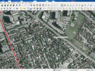
The Ottawa Tree Canopy Cover Mapping Project
The City of Ottawa Official Plan set a target of 30% tree canopy cover for the entire city. To the author’s knowledge there is no information on the amount of tree canopy for the entire […]
In 1960 Canada brought the first GIS to use. We can thank Dr. Roger Tomlinson for this genesis. He called the first true GIS, The Canada Geographic Information System. GIS is now an indispensable tool the […]
GoGeomatics: Welcome to the GoGeomatics Canada community. To get started can you tell us about where you are from and why you decided to make a career of GIS? Darin Brooks: Thanks for having me […]
GoGeomatics Canada is talking to Lawrie Keillor-Faulkner a member of the GIS Faculty at Fleming College in Ontario. GoGeomatics: Welcome to the GoGeomatics Canada community. To get started can you tell us about where you […]
I’ve been asked to lead a GIS program review for our College; we want to try to anticipate future trends (or act nimbly to adapt to them) and ensure we are delivering courses containing skills […]
What is the power of GIS? What we have to do is separate GIS from software and hardware. GIS has been on this planet a lot longer than computers, servers, and […]
Location: Brock University Campus. Welch Hall. Room is WH #202 Date: September 30th, 2012 Starting Time: This half day seminar begins at 9am 500 Glenridge Ave., St. Catharines, Ontario Cost: $50 Special Announcement: GoGeomatics is […]
GoGeomatics: Welcome to the GoGeomatics Canada community. First off, can you tell us about where you are from and where you have lived throughout your GIS career? Brad Maguire: Thanks very much. I grew up outside […]