• facebook
  • Twitter
  • Linkedin
  • Youtube
  • Linkedin Group
  • Post a Job
  • Post an Ad
  • Post an Event
  • Post a Directory Listing
  • Post a Press Release
  • Media Kit
  • My Account
  • Login
GoGeomatics
  • MAGAZINE
    • BIM & GIS
    • Community
    • Conference news
    • Earth Observation
    • Education & Careers
    • GEOAI
    • Announcements
    • Reality Capture & Lidar
    • Science
    • Technology
  • Directories
    • ASSOCIATION
    • INDUSTRY
    • EDUCATION
    • Open Data
  • EVENTS
    • GeoIgnite Events
    • Events Calendar
    • GoGeomatics Meetups
  • Services
    • Advertising
    • Marketing
    • Post a Job
    • Post an Ad
    • Post an Event
    • Post a Press Release
    • Post a Directory Listing
    • Media Kit
    • Web Design
  • Find a Job
  • Volunteer
    • Start a GoGeomatics Group
    • Editors & Writers Group
  • About Us
    • About Us
    • Contact Us
    • Frequently Asked Questions
  • Videos
Homesar

sar

Robert E Lee|George Meade|Lutheran Seminary|Lutheran Seminary with Union Line
Education & Careers

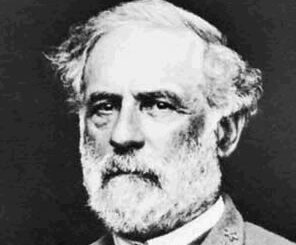
Gettysburg: What Could Lee See?

29 July 2014 Bert V. de Bruijn | aerial

In an age devoid of modern communications methods and digital maps, military generals often made tactical decisions based on what they could see with their own eyes. In studying the Battle of Gettysburg, many people […]

No Picture
Community

Did You Know You Can Help Build and Implement a National Geomatics Action Plan?

14 July 2014 GoGeomatics Canada | association

At the June 9 and 10 CGCRT Team Canada event, the attendees were called upon to join working groups in order to help implement and define the National Geomatics Action Plan. We wanted to let […]

|
Community

All the Geomatics Acronyms You Wanted to Know but were Too Afraid to Ask

27 June 2014 GoGeomatics Canada | 2012

Here in Canada, there are many geomatics acronyms that get tossed around. During the recent “Team Canada” event that the CGCRT put on, more than one participant was scratching their heads, asking questions like…what is […]

|||
Community

Product Launch – Geomatica 2014 from PCI Geomatics

23 June 2014 GoGeomatics Canada | 2014

GoGeomatics Canada recently attended the launch of PCI Geomatics’ latest version of Geomatica 2014, the integrated desktop image processing software. The event took place June 19 at the stylish Gatineau Golf Club at a cocktail-style […]

No Picture
Newsmakers & Press Releases

DMTI Spatial Partners with JBA Risk Management to Provide an Integrated Offering for Reducing Risk and Forecasting Exposure

3 June 2014 GoGeomatics Newsmakers | 2013

New partnership provides insurers and financial institutions with enhanced real-time risk information DMTI Spatial Inc. (DMTI), Canada’s leading provider of location economics solutions, and JBA Risk Management, a leading provider of natural hazard modelling services […]

Survey career|Surveying career
Education & Careers

Career Profile: Land Surveyor

28 May 2014 GoGeomatics Canada | alberta

Are you considering launching a career in land surveying? Wondering what this career has in store? Read on to learn about the job description, education, skills, expected salary and more to find out if this […]

No Picture
Newsmakers & Press Releases

PCI Geomatics Expands Training Program by Providing Free Access to Online Coursebooks

21 May 2014 GoGeomatics Newsmakers | 2014

RICHMOND HILL, Ontario, Canada – May 14, 2014: PCI Geomatics, a world-leading developer of remote sensing and photogrammetric software and systems, announced today that the company is making its training textbooks available to the general […]

Western Canada tour||come to a social
Community

GoGeomatics Canada Heads West for an Anniversary Tour

12 May 2014 GoGeomatics Canada | alberta

One year ago, GoGeomatics Canada became a truly national endeavor, from coast to coast. For the first time, our monthly pub socials came to Vancouver and Calgary. This month, GoGeomatics Canada’s own Jonathan Murphy is […]

Posts pagination

« 1 … 13 14 15 … 20 »

Events

Notice
There are no upcoming events.

View All Events

Services

  • Post a Job
  • Post an Ad
  • Post an Event
  • Post a Directory Listing
  • Post a Press Release
  • Media Kit
  • My Account
  • Login

Jobs

Post a Job
  • Canada Maps and Poster Gallery Volunteer Leads — GeoIgnite 2026
    remote
  • GIS & Data Analytics Lead
    Beaumont, AB
  • Lead Surveyor, Projects/Arpenteur-géomètre principal, projets; arpenteuse-géomètre principale, projets
    North Bay, Thunder Bay
  • Senior GIS Developer
    Calgary, AB
View All Jobs
  • Directories
    • Associations Directory
    • Industry Directory
    • Education Programs
    • Open Data
  • Volunteer
    • Start a GoGeomatics Group
    • Editors & Writers Group
  • About Us
    • GoGeomatics Media Kit
    • Who We Are
    • Contact Us
    • FAQ’s
    • Advertising
    • Marketing
  • Subscribe
GoGeomatics
GoGeomatics is the largest and most popular communications hub promoting the Canadian geospatial community. The business was incorporated in 2011. GoGeomatics hosts over 100 fun, free, location technology networking events each year in cities across Canada.

© 2025 GoGeomatics

  • facebook
  • Twitter
  • Linkedin
  • Youtube
  • Linkedin Group